2025
Schad, T. (Bayer AG); Bub, S. (Rheinland‐Pfälzische Technische Universität); Wang, M. (WSC Scientific GmbH); Holmes, C.M. (Applied Analysis Solutions, LLC); Kleinmann, J. (WSC Scientific GmbH); Hammel, K. (Bayer AG); Ernst, G. (Bayer AG); Preuss, T.G. (Bayer AG)
IEAM Best Paper of 2024 Best Paper Journal Article
In: Integrated Environmental Assessment and Management, vol. 21, iss. 4, pp. 733-734, 2025.
@article{best-paper-2024,

title = {IEAM Best Paper of 2024},

author = {Schad, T. (Bayer AG) and Bub, S. (Rheinland‐Pfälzische Technische Universität) and Wang, M. (WSC Scientific GmbH) and Holmes, C.M. (Applied Analysis Solutions, LLC) and Kleinmann, J. (WSC Scientific GmbH) and Hammel, K. (Bayer AG) and Ernst, G. (Bayer AG) and Preuss, T.G. (Bayer AG)},

url = {https://academic.oup.com/ieam/article/21/4/733/8175201, View Article},

doi = {10.1093/inteam/vjaf053},

year  = {2025},

date = {2025-06-30},

urldate = {2025-06-30},

journal = {Integrated Environmental Assessment and Management},

volume = {21},

issue = {4},

pages = {733-734},

abstract = {WINNER OF THE 2024 BEST PAPER AWARD:


A spatiotemporally explicit modeling approach for more realistic exposure and risk assessment of off‐field soil organisms


Thorsten Schad, Sascha Bub, Magnus Wang, Christopher M. Holmes, Joachim Kleinmann, Klaus Hammel, Gregor Ernst, and Thomas G. Preuss


DOI: 10.1002/ieam.4798


As a result of spray drift and runoff from adjacent fields, soil living organisms in cultivated landscapes can be exposed unintentionally to pesticides. Current approaches to estimating such off-field exposure employ conservative, worst-case assumptions that do not account for real-world variability of exposure in space and time. Schad et al. (2024) develop a modeling approach, scenarios, and a case study to gain more realistic estimates of exposure, and hence risk, and to inform mitigation options. Their model is probabilistic and spatiotemporally explicit. It has the advantage of separating the factors influencing spray drift (e.g., wind, application timing and conditions, off-field soil patch dimensions, and spatial relationship to fields) and runoff (e.g., temporal relationship between product residues and precipitation as well as landscape morphology). Their results show that spatiotemporally explicit exposure patterns for spray drift and runoff are not simply additive. Their work demonstrates that landscape composition and structure clearly affect exposure to off-field soil organisms. Their model facilitates identification of local runoff hotspots that can be targeted for appropriate mitigation efforts. The approach is flexible and can operate at any desired spatial and temporal resolution, thus capturing variability of pesticide use, spray drift, and runoff to more accurately estimate off-field exposure patterns. The predicted exposure patterns can be directly linked with effect models to quantify risks related to specific protection goals. Because the authors have made the model available as open-source software, this should facilitate further model improvements and applications in the regulatory scientific community.},

keywords = {2024},

pubstate = {published},

tppubtype = {article}

}
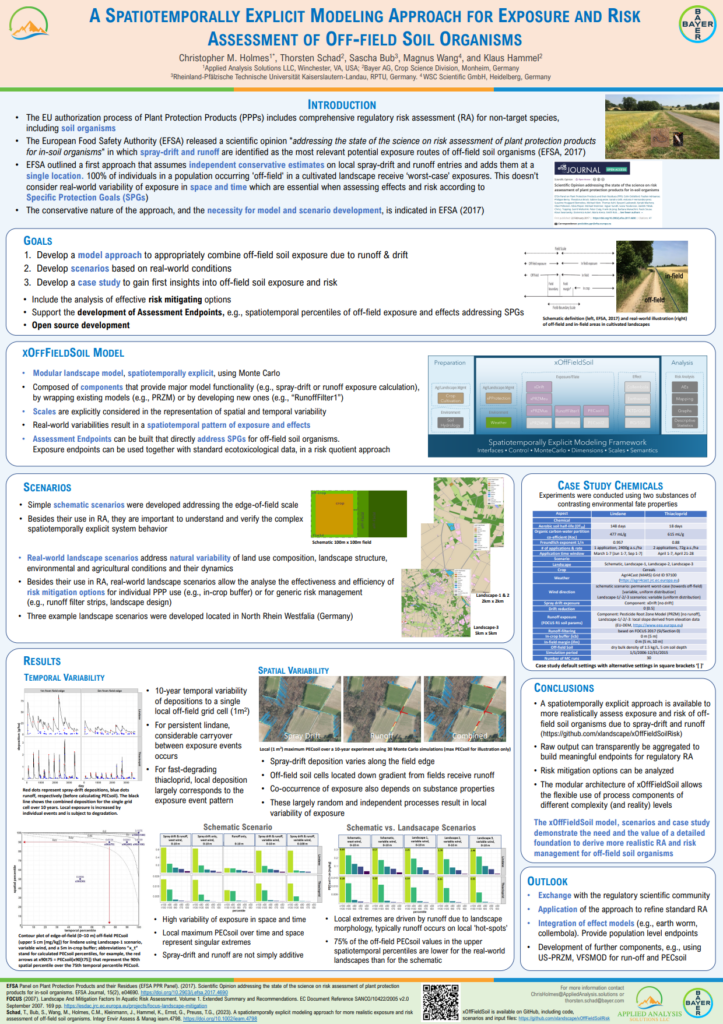
A spatiotemporally explicit modeling approach for more realistic exposure and risk assessment of off‐field soil organisms
Thorsten Schad, Sascha Bub, Magnus Wang, Christopher M. Holmes, Joachim Kleinmann, Klaus Hammel, Gregor Ernst, and Thomas G. Preuss
DOI: 10.1002/ieam.4798
As a result of spray drift and runoff from adjacent fields, soil living organisms in cultivated landscapes can be exposed unintentionally to pesticides. Current approaches to estimating such off-field exposure employ conservative, worst-case assumptions that do not account for real-world variability of exposure in space and time. Schad et al. (2024) develop a modeling approach, scenarios, and a case study to gain more realistic estimates of exposure, and hence risk, and to inform mitigation options. Their model is probabilistic and spatiotemporally explicit. It has the advantage of separating the factors influencing spray drift (e.g., wind, application timing and conditions, off-field soil patch dimensions, and spatial relationship to fields) and runoff (e.g., temporal relationship between product residues and precipitation as well as landscape morphology). Their results show that spatiotemporally explicit exposure patterns for spray drift and runoff are not simply additive. Their work demonstrates that landscape composition and structure clearly affect exposure to off-field soil organisms. Their model facilitates identification of local runoff hotspots that can be targeted for appropriate mitigation efforts. The approach is flexible and can operate at any desired spatial and temporal resolution, thus capturing variability of pesticide use, spray drift, and runoff to more accurately estimate off-field exposure patterns. The predicted exposure patterns can be directly linked with effect models to quantify risks related to specific protection goals. Because the authors have made the model available as open-source software, this should facilitate further model improvements and applications in the regulatory scientific community.
Holmes, C.M. (Applied Analysis Solutions, LLC); Austin, T. (Haleon CH SARL); Oram, S. (Haleon UK); Argoud, S. (AstraZeneca); Owen, S. (AstraZeneca)
05.11.2025.
Abstract | Links | Tags: 2025, Poster, SETAC Europe
@misc{EU25CallToAction,

title = {A Call to Action: Accurate Mapping of Emissions to Global Freshwater Systems is Strategically Important for Chemical Exposure Prediction and Mitigation},

author = {Holmes, C.M. (Applied Analysis Solutions, LLC) and Austin, T. (Haleon CH SARL) and Oram, S. (Haleon UK) and Argoud, S. (AstraZeneca) and Owen, S. (AstraZeneca)},

url = {https://appliedanalysis.solutions/wp-content/uploads/2025/05/SETAC-EU-2025-Global-Model.pdf, View Poster},

year  = {2025},

date = {2025-05-11},

urldate = {2025-05-11},

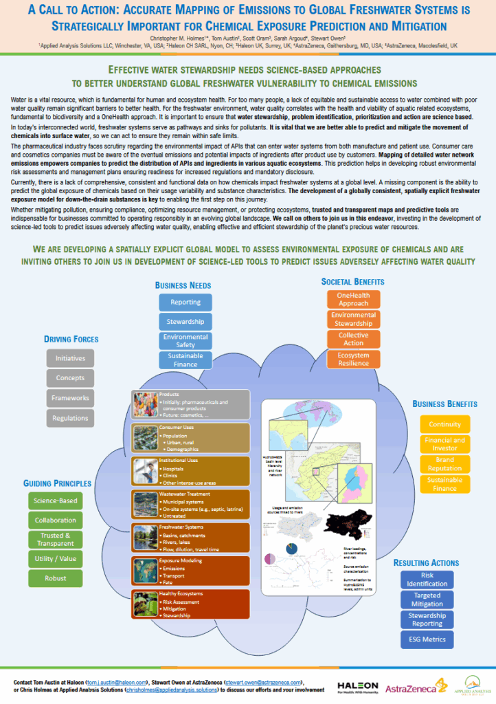
abstract = {Water is a vital resource, which is fundamental for human and ecosystem health. For too many people, a lack of equitable and sustainable access to water combined with poor water quality remain significant barriers to better health. For the freshwater environment, water quality correlates with the health and viability of aquatic related ecosystems, fundamental to biodiversity and a OneHealth approach. It is important to ensure that water stewardship, problem identification, prioritization and action are science based. In today's interconnected world, freshwater systems serve as pathways and sinks for pollutants. It is vital that we are better able to predict and mitigate the movement of chemicals into surface water, so we can act to ensure they remain within safe limits. The pharmaceutical industry faces scrutiny regarding the environmental impact of APIs that can enter water systems from both manufacture and patient use. Consumer care and cosmetics companies must be aware of the eventual emissions and potential impacts of ingredients after product use by customers. Mapping of detailed water network emissions empowers companies to predict the distribution of APIs and ingredients in various aquatic ecosystems. This prediction helps in developing robust environmental risk assessments and management plans ensuring readiness for increased regulations and mandatory disclosure. Currently, there is a lack of comprehensive, consistent and functional data on how chemicals impact freshwater systems at a global level. A missing component is the ability to predict the global exposure of chemicals based on their usage variability and substance characteristics. The development of a globally consistent, spatially explicit freshwater exposure model for down-the-drain substances is key to enabling the first step on this journey. Whether mitigating pollution, ensuring compliance, optimizing resource management, or protecting ecosystems, trusted and transparent maps and predictive tools are indispensable for businesses committed to operating responsibly in an evolving global landscape. We call on others to join us in this endeavor, investing in the development of science-led tools to predict issues adversely affecting water quality, enabling effective and efficient stewardship of the planet's precious water resources.},

keywords = {2025, Poster, SETAC Europe},

pubstate = {published},

tppubtype = {presentation}

}
Holmes, C.E. (Applied Analysis Solutions, LLC); Schad, T. (Bayer AG, Crop Science Division); Bub, S. (Rheinland‐Pfälzische Technische Universität); Holmes, C.M. (Applied Analysis Solutions, LLC)
05.11.2025.
Abstract | Links | Tags: 2025, Poster, SETAC Europe
@misc{EU25CropProtection,

title = {xCropProtection: a Spatiotemporal Component to Simulate Prospective and Retrospective PPP Applications in Real World Landscapes},

author = {Holmes, C.E. (Applied Analysis Solutions, LLC) and Schad, T. (Bayer AG, Crop Science Division) and Bub, S. (Rheinland‐Pfälzische Technische Universität) and Holmes, C.M. (Applied Analysis Solutions, LLC)},

url = {https://appliedanalysis.solutions/wp-content/uploads/2025/05/SETAC-EU-2025-xCropProtection.pdf, View Poster},

year  = {2025},

date = {2025-05-11},

urldate = {2025-05-11},

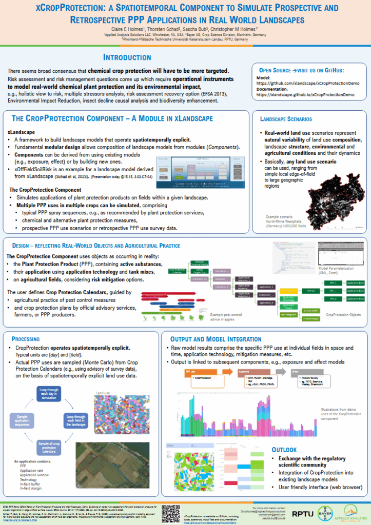
abstract = {There is currently both scientific and public discussion about chemical crop protection uses and trends. There seems to be consensus that chemical crop protection should be generally reduced or used more targeted in the future. In parallel there are requests for more realistic and holistic risk assessments of pesticides. We developed a spatiotemporally explicit component for simulating plant protection product (PPP) applications in landscapes which integrates with a larger spatiotemporal landscape model (xLandscape). This component, xCropProtection, can simulate applications at a field scale given PPP application information including target crops, spatial landscape information, and application periods. The result of running this component is a multidimensional dataset of PPP applications specific to individual fields and time steps. xCropProtection is parameterized with XML files, a file type used to store data in a hierarchical format well suited for sending and storing data. These XML files contain target crop types, PPP (or active substance) names, tank mixes, application rates (as a probability distribution function or a static value), probabilistic application windows, and mitigation measures for reducing exposure. xCropProtection functions both prospectively and retrospectively where input files can come from GAP tables in established risk assessment, can represent recommendations from plant protection advisory services, records from monitoring and field studies, or can be derived from market share grower surveys. xCropProtection is one component in the larger xLandscape framework that provides the simulation of more realistic pesticide applications for exposure, effect and risk assessments. },

keywords = {2025, Poster, SETAC Europe},

pubstate = {published},

tppubtype = {presentation}

}
Hodges, G. (Unilever Safety, Environmental & Regulatory Science); Hodges, J. (Unilever Safety, Environmental & Regulatory Science); Holmes, C.M. (Applied Analysis Solutions, LLC); Sheffield, D. (Unilever Safety, Environmental & Regulatory Science); Insinga, L. (Applied Analysis Solutions, LLC); Sandha, S. (Unilever Safety, Environmental & Regulatory Science); Tandy, E. (Applied Analysis Solutions, LLC); Dannatt, R. (Intertek Metoc); McGovern, K. (Intertek Metoc); Langley, E. (Intertek Metoc)
Estimating global spatially resolved marine emissions and exposure to down the drain chemicals Presentation
05.11.2025.
Abstract | Links | Tags: 2025, Poster, SETAC Europe
@misc{EU25Marine,

title = {Estimating global spatially resolved marine emissions and exposure to down the drain chemicals},

author = {Hodges, G. (Unilever Safety, Environmental & Regulatory Science) and Hodges, J. (Unilever Safety, Environmental & Regulatory Science) and Holmes, C.M. (Applied Analysis Solutions, LLC) and Sheffield, D. (Unilever Safety, Environmental & Regulatory Science) and Insinga, L. (Applied Analysis Solutions, LLC) and Sandha, S. (Unilever Safety, Environmental & Regulatory Science) and Tandy, E. (Applied Analysis Solutions, LLC) and Dannatt, R. (Intertek Metoc) and McGovern, K. (Intertek Metoc) and Langley, E. (Intertek Metoc)},

url = {https://appliedanalysis.solutions/wp-content/uploads/2025/05/SETAC-EU-202S-Marine-Modelling.pdf, View Poster},

year  = {2025},

date = {2025-05-11},

urldate = {2025-05-11},

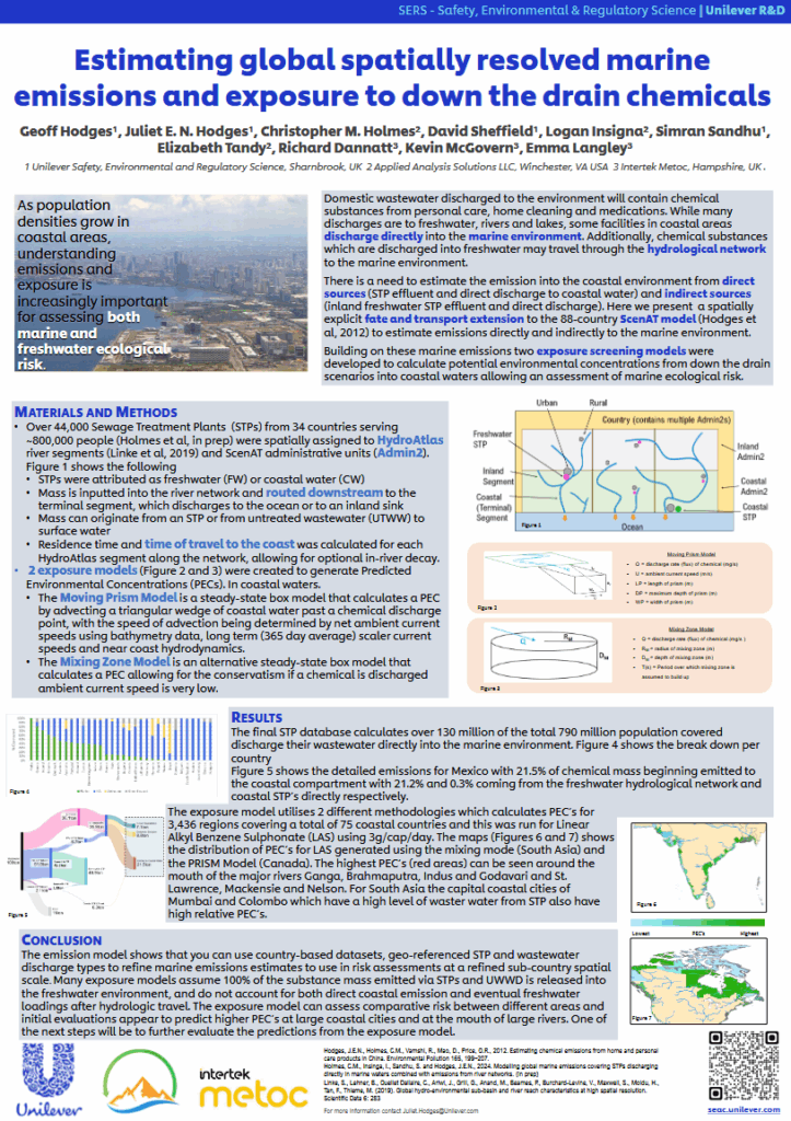
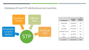
abstract = {Domestic wastewater discharged to the environment may contain chemical substances that are the result of human activity. While many discharges are to freshwater rivers and lakes, some facilities in coastal areas discharge directly into the marine environment. however many down-the-drain exposure models assume 100% of the chemical mass discharged from STPs or untreated populations is released into the freshwater environment A dataset was developed to understand what fraction of the population in coastal areas are served by STPs that discharge directly to a marine environment. Information on STP location, population served, and effluent flow were collected for 44,000 STPs across 34 countries serving almost 800 million people


Chemical substances are also discharged into freshwater which then may travel through the hydrological network to the marine environment. Hydrologic travel distance/time for each inland STP as well as untreated mass was developed along with estimated aquatic half-lives, to estimate discharges into rivers moving to coastal waters. The developed emission model is a mass balance model.

The third phase of the study developed two exposure models for 3436 regions covering 75 coastal countries to generate Predicted Environmental Concentrations (PEC s). The Moving Prism Model is a steady-state box model that calculates a PEC by advecting a triangular wedge of coastal water past a chemical discharge point, with the speed of advection being determined by net ambient current speeds using bathymetry data, long term (365-day average) scaler current speeds and near coast hydrodynamics. The Mixing Zone Model is an alternative steady-state box model that calculates a PEC should a chemical be discharged into still water (i.e. with no ambient current speed). Some initial comparisons to monitoring data show good agreement.


This work shows that it is possible to use country-based datasets including geo-referenced STP and wastewater discharge types to refine emissions estimates for use in environmental exposure models and risk assessments at a refined sub-country spatial scale.

The exposure model provides a screening level, globally-consistent approach for assessing the potential impact of down-the-drain chemicals on the marine environment. These models generate estimates of Predicted Environmental Concentration and represent an intermediate level between generic, multi-media models and detailed, data hungry process-based models.},

keywords = {2025, Poster, SETAC Europe},

pubstate = {published},

tppubtype = {presentation}

}
Chemical substances are also discharged into freshwater which then may travel through the hydrological network to the marine environment. Hydrologic travel distance/time for each inland STP as well as untreated mass was developed along with estimated aquatic half-lives, to estimate discharges into rivers moving to coastal waters. The developed emission model is a mass balance model.
The third phase of the study developed two exposure models for 3436 regions covering 75 coastal countries to generate Predicted Environmental Concentrations (PEC s). The Moving Prism Model is a steady-state box model that calculates a PEC by advecting a triangular wedge of coastal water past a chemical discharge point, with the speed of advection being determined by net ambient current speeds using bathymetry data, long term (365-day average) scaler current speeds and near coast hydrodynamics. The Mixing Zone Model is an alternative steady-state box model that calculates a PEC should a chemical be discharged into still water (i.e. with no ambient current speed). Some initial comparisons to monitoring data show good agreement.
This work shows that it is possible to use country-based datasets including geo-referenced STP and wastewater discharge types to refine emissions estimates for use in environmental exposure models and risk assessments at a refined sub-country spatial scale.
The exposure model provides a screening level, globally-consistent approach for assessing the potential impact of down-the-drain chemicals on the marine environment. These models generate estimates of Predicted Environmental Concentration and represent an intermediate level between generic, multi-media models and detailed, data hungry process-based models.
2024
Christian, D. (Applied Analysis Solutions, LLC); Kern, M. (Balance EcoSolutions, LLC); Holmes, C.M. (Applied Analysis Solutions, LLC); Kay, S. (Pyxis Regulatory Consulting, Inc); Cowles, J. (Tessenderlo Kerley, Inc.); Henry, K. (Tessenderlo Kerley, Inc.)
10.20.2024.
Abstract | Links | Tags: 2024, Presentation, SETAC North America
@misc{2024NA-PULAs,

title = {Creating More Refined Pesticide Mitigation Areas Informed by Our Familiarity With Species Spatial Data in Support of Carbamate Biological Opinion Development},

author = {Christian, D. (Applied Analysis Solutions, LLC) and Kern, M. (Balance EcoSolutions, LLC) and Holmes, C.M. (Applied Analysis Solutions, LLC) and Kay, S. (Pyxis Regulatory Consulting, Inc) and Cowles, J. (Tessenderlo Kerley, Inc.) and Henry, K. (Tessenderlo Kerley, Inc.)},

url = {https://appliedanalysis.solutions/wp-content/uploads/2024/10/SETAC-NA-2024-PULAs-Carbamate-BO.pdf, View Presentation},

year  = {2024},

date = {2024-10-20},

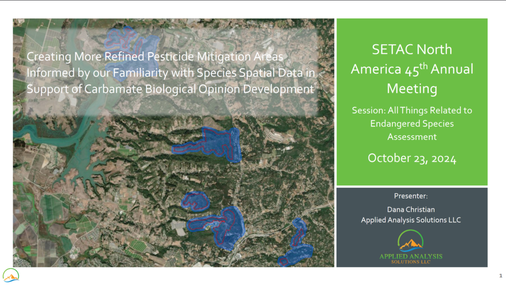
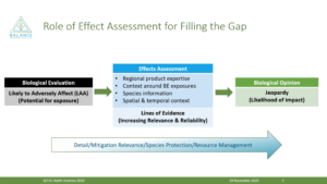
abstract = {Pesticide mitigation areas are designed to ensure a pesticide’s use will be protective of listed endangered or threatened species and their critical habitat. A species range can be geographically broad and can include areas unsuitable for habitat due to various environmental factors. There is a need to create more spatially refined pesticide mitigation areas (e.g., Pesticide Use Limitation Areas, PULAs) to better identify habitats where mitigation may be required. We have implemented a process during recent work with carbamates which has allowed us to explore more detailed habitat definitions to refine areas within a species range that, according to the most recent documentation from FWS, are required for a species’ continued recovery. We have worked to develop a “core map” representing locations of the species where mitigations are needed based on species range, critical habitat, known locations, and suitable habitat. We have focused on using the best publicly available spatial datasets in conjunction with the most recent FWS species documentation to build detailed core maps for a wide variety of endangered species. Experience has shown us that, while challenges with resources and uncertainty exist, this range refinement process is possible and valuable for assessment of risk to many endangered species. This presentation lays out the lessons learned and choices made while developing more refined pesticide mitigation areas, based on our extensive experience with species range, critical habitat, potentially suitable habitat and known locations in support of the carbamate BOs.},

keywords = {2024, Presentation, SETAC North America},

pubstate = {published},

tppubtype = {presentation}

}
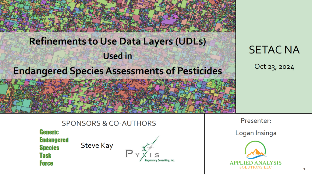
Insinga, L. (Applied Analysis Solutions, LLC); Kay, S. (Pyxis Regulatory Consulting, Inc)
Refinements to Use Data Layers (UDLs) Used in Endangered Species Assessments of Pesticides Presentation
10.20.2024.
Abstract | Links | Tags: 2024, Presentation, SETAC North America
@misc{2024NA-CSB,

title = {Refinements to Use Data Layers (UDLs) Used in Endangered Species Assessments of Pesticides},

author = {Insinga, L. (Applied Analysis Solutions, LLC) and Kay, S. (Pyxis Regulatory Consulting, Inc)},

url = {https://appliedanalysis.solutions/wp-content/uploads/2024/10/SETAC-NA-2024-CSB-Based-UDLs.pdf, View Presentation},

year  = {2024},

date = {2024-10-20},

urldate = {2024-10-20},

abstract = {In their Endangered Species (ES) assessments for pesticides, the US Environmental Protection Agency (EPA), US Fish and Wildlife Service (FWS) and National Marine Fisheries Service (NMFS) use datasets called Use Data Layers (UDLs) to spatially delineate potential pesticide use sites. For agricultural uses, the UDLs are currently generated from the US Department of Agriculture’s (USDA) Cropland Data Layer (CDL) raster dataset, which is created using a machine learning classification algorithm applied to satellite imagery, agricultural ground truth data, and other ancillary datasets. The current approach for generating agricultural UDLs sources 5 years of CDL datasets which are processed by grouping the more than 100 individual CDL cultivated classes into 13 general UDL classes. While this approach is robust, there are some challenges. One challenge with generating agricultural UDLs is the presence of “spurious pixels” or highly fragmented areas of the UDL that are known to be false-positive classifications (i.e., non-agricultural raster cells classified as agriculture) carried through from the source CDL dataset. The presence of spurious pixels can result in inaccurate estimations of co-occurrence between UDLs and listed species locations, and it is desirable to remove spurious pixels to the greatest extent possible. However, it is difficult to identify and filter spurious pixels in a programmatic way given the nature of the remotely sensed source dataset. Furthermore, it is undesirable to remove actual agriculture from the UDLs, which can occur if agricultural pixels are misidentified as spurious. To address this issue, we propose to mitigate the presence of spurious pixels by incorporating additional processing steps to generate more accurate UDLs. This method builds on the USDA’s refinement of the base raster CDL data into a vector Crop Sequence Boundary (CSB) dataset that uses publicly available data and employs a transparent yet efficient processing workflow. This new methodology virtually eliminates spurious pixels from the UDLs and provides the added benefit of significantly improved processing efficiency leading to a reduction in processing time from weeks for the original CDL based approach to overnight using the new CSB based approach.},

keywords = {2024, Presentation, SETAC North America},

pubstate = {published},

tppubtype = {presentation}

}
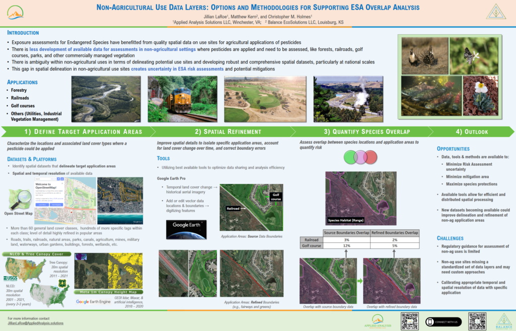
LaRoe, J. (Applied Analysis Solutions, LLC); Kern, M. (Balance EcoSolutions, LLC); Holmes, C.M. (Applied Analysis Solutions, LLC)
Non-Agricultural Use Data Layers: Options and Methodologies for Supporting ESA Overlap Analysis Presentation
10.20.2024.
Abstract | Links | Tags: 2024, Poster, SETAC North America
@misc{NA24UDL,

title = {Non-Agricultural Use Data Layers: Options and Methodologies for Supporting ESA Overlap Analysis},

author = {LaRoe, J. (Applied Analysis Solutions, LLC) and Kern, M. (Balance EcoSolutions, LLC) and Holmes, C.M. (Applied Analysis Solutions, LLC)},

url = {https://appliedanalysis.solutions/wp-content/uploads/2024/10/SETAC-NA-2024-NonAgricultural-Use-Data-Layers-Options-and-Methodologies.pdf, View Poster},

year  = {2024},

date = {2024-10-20},

urldate = {2024-10-20},

abstract = {Exposure assessments for Endangered Species have benefitted from quality spatial data on use sites for agricultural applications of pesticides. There is less development of available data for assessments in non-agricultural settings where pesticides are applied and need to be assessed, like forests, railroads, golf courses, parks, and other commercially managed vegetation. The emphasis on agricultural use sites has produced refined methodologies as well as defined and delineated data sets (e.g., Use Data Layers). However, there is ambiguity within non-agricultural uses in terms of delineating potential use sites and developing robust and comprehensive spatial datasets, particularly at national scales. Recent advancements in data processing/platforms along with the scale and extent of available spatial data present an opportunity to develop more comprehensive datasets for non-agricultural overlap analyses (relationship of use sites to species habitats). We have created customized approaches leveraging detailed datasets, like Open Street Map, to help fill this data gap. We incorporated additional information from other sources, such as historical high resolution aerial imagery, to support boundary editing and refinement of application areas. We present a combination of data sources and methods that can be tailored to curate data for specific objectives, tools and strategies to refine potential exposure for non-agricultural scenarios, as well as applied examples using golf courses, railroad vegetation management, and forests.},

keywords = {2024, Poster, SETAC North America},

pubstate = {published},

tppubtype = {presentation}

}
Holmes, C.M. (Applied Analysis Solutions, LLC); Schad, T. (Bayer CropScience); Bub, S. (Rheinland‐Pfälzische Technische Universität); Wang, M. (WSC Scientific GmbH); Hammel, K. (Bayer AG)
A Spatiotemporally Explicit Modeling Approach for Exposire and Risk Assessment of Off-field Soil Organisms Presentation
05.05.2024.
Abstract | Links | Tags: 2024, Poster, SETAC Europe
@misc{EU24xOffFieldSoil,

title = {A Spatiotemporally Explicit Modeling Approach for Exposire and Risk Assessment of Off-field Soil Organisms},

author = {Holmes, C.M. (Applied Analysis Solutions, LLC) and Schad, T. (Bayer CropScience) and Bub, S. (Rheinland‐Pfälzische Technische Universität) and Wang, M. (WSC Scientific GmbH) and Hammel, K. (Bayer AG)},

url = {https://appliedanalysis.solutions/wp-content/uploads/2024/05/SETAC-EU-2024-xOffFieldSoil.pdf, View Poster

https://github.com/xlandscape/xOffFieldSoilRisk, GitHub Repository},

year  = {2024},

date = {2024-05-05},

urldate = {2024-05-05},

abstract = {Natural and semi-natural habitats of soil living organisms in cultivated landscapes can be subject to unintended exposure by active substances of pesticides used in adjacent fields. Spray-drift deposition and runoff are considered major exposure routes into such off-field areas. In this work we develop a model (xOffFieldSoil) and associated scenarios to estimate exposure of off-field soil habitats at flexible levels of realism (https://github.com/xlandscape/xOffFieldSoilRisk). The modular approach consists of components each addressing a specific aspect of exposure processes, e.g., pesticide use, drift deposition, runoff generation and filtering, and PECsoil estimation. The approach is spatiotemporally explicit and operates at scales ranging from local edge-of-field to large landscapes. The outcome can be aggregated and presented as comprehensible endpoints to the risk assessor, considering ecologically relevant dimensions and scales for species protection. The approach also assesses the effect of mitigation options, e.g., field margins, in-field buffers, or drift-reducing technology. Presented scenarios start with a schematic edge-of-field situation and extend to real-world landscapes of up to 5 km x 5 km. A case study was conducted for two active substances of different environmental fate characteristics. Results are presented as a collection of percentiles over time and space, as contour plots and as maps. The results show that exposure patterns of off-field soil organisms are of a complex nature due to spatial and temporal variabilities combined with landscape structure and event-based processes. Our concepts and preliminary analysis demonstrate that more realistic exposure data can be meaningfully consolidated to serve in standard-tier risk assessments. The real-world landscape-scale scenarios indicate risk hot-spots which support the identification of efficient risk mitigation. As a next step, the spatiotemporally explicit exposure data can be directly coupled to ecological effect models (e.g., for earthworms or collembola) to conduct risk assessments at biological entity levels.},

keywords = {2024, Poster, SETAC Europe},

pubstate = {published},

tppubtype = {presentation}

}
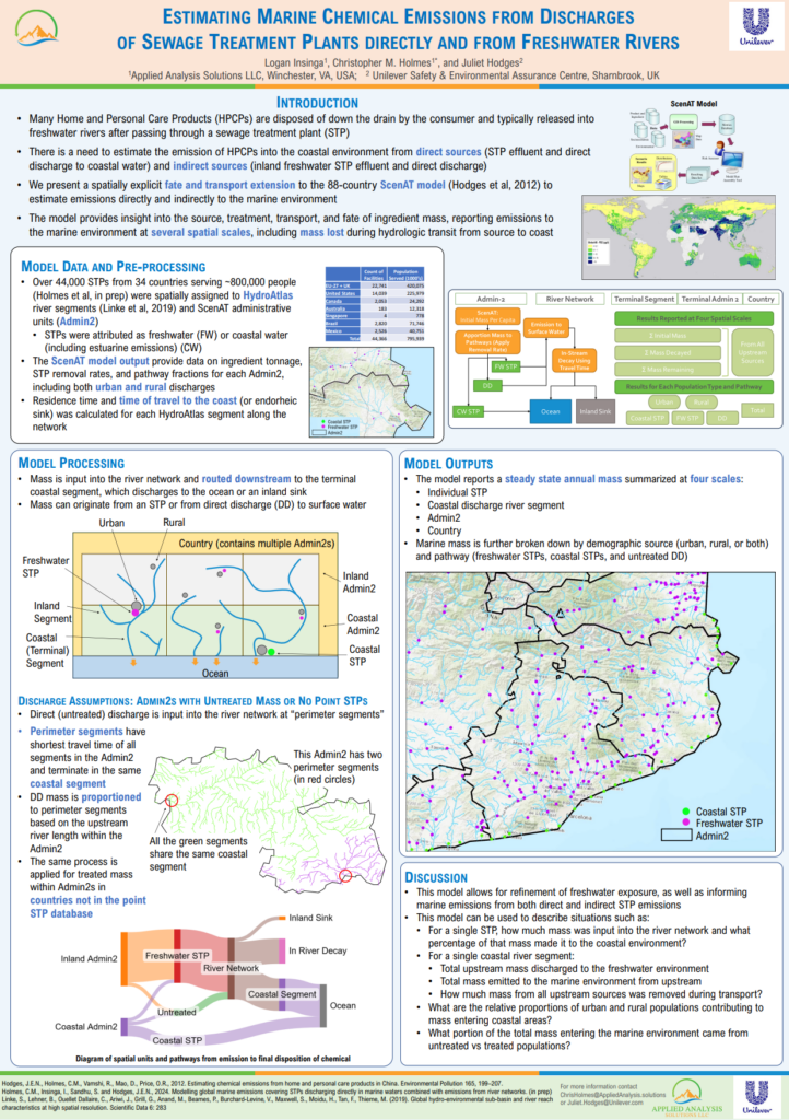
Insinga, L. (Applied Analysis Solutions, LLC); Holmes, C.M. (Applied Analysis Solutions, LLC); Hodges, J. (Unilever Safety & Environmental Assurance Centre)
Estimating Marine Chemical Emissions from Discharges of Sewage Treatment Plants Directly and from Freshwater Rivers Presentation
05.05.2024.
Abstract | Links | Tags: 2024, Poster, SETAC Europe
@misc{EU24STP,

title = {Estimating Marine Chemical Emissions from Discharges of Sewage Treatment Plants Directly and from Freshwater Rivers},

author = {Insinga, L. (Applied Analysis Solutions, LLC) and Holmes, C.M. (Applied Analysis Solutions, LLC) and Hodges, J. (Unilever Safety & Environmental Assurance Centre)},

url = {https://appliedanalysis.solutions/wp-content/uploads/2024/05/SETAC-EU-2024-Marine-Exposure-Model.pdf, View Poster},

year  = {2024},

date = {2024-05-05},

urldate = {2024-05-05},

abstract = {Changes in demographics are leading to greater urbanization and higher coastal populations which in turn is increasing the need to better understand chemical loading into coastal and marine environments. Many Home and Personal Care Products (HPCPs) are disposed of down the drain by the consumer, whereupon the ingredients typically are released into freshwater rivers having passed through upstream sewage treatment plants (STPs). Further transport to the marine environment can take place. However, there is a currently paucity of approaches to adequately estimate the extent of this emission route into the environment.


Following on from previous work from our group estimating chemical mass discharged directly into marine environments, here we present an approach which utilizes data on hydrologic travel distance/time for inland STPs combined with estimated aquatic half-lives to estimate emissions from upstream STPs into rivers flowing to coastal areas.


We have developed a spatially explicit fate and transport model to estimate emissions into the marine environment across 88 countries. This global model utilizes the HydroAtlas river dataset and covers 44,000 STPs in 34 countries which discharge into both freshwater and coastal waters directly. Ingredient mass discharged from freshwater STPs was estimated using hydrologic routing from the STP and estimated aquatic half-lives to the coastal discharge location. Discharged mass and percent of mass reaching the coast can then be calculated.

Resulting information can be used to refine emission estimates of ingredients into marine environments based on population demographics, disposal scenarios, and STP hydrologic distance to the coast. Results can also be used to inform more refined marine exposure modelling for risk assessment purposes.},

keywords = {2024, Poster, SETAC Europe},

pubstate = {published},

tppubtype = {presentation}

}
Following on from previous work from our group estimating chemical mass discharged directly into marine environments, here we present an approach which utilizes data on hydrologic travel distance/time for inland STPs combined with estimated aquatic half-lives to estimate emissions from upstream STPs into rivers flowing to coastal areas.
We have developed a spatially explicit fate and transport model to estimate emissions into the marine environment across 88 countries. This global model utilizes the HydroAtlas river dataset and covers 44,000 STPs in 34 countries which discharge into both freshwater and coastal waters directly. Ingredient mass discharged from freshwater STPs was estimated using hydrologic routing from the STP and estimated aquatic half-lives to the coastal discharge location. Discharged mass and percent of mass reaching the coast can then be calculated.
Resulting information can be used to refine emission estimates of ingredients into marine environments based on population demographics, disposal scenarios, and STP hydrologic distance to the coast. Results can also be used to inform more refined marine exposure modelling for risk assessment purposes.
Holmes, C.M. (Applied Analysis Solutions, LLC); Insinga, L. (Applied Analysis Solutions, LLC); Kay, S. (Pyxis Regulatory Consulting, Inc); Kern, M. (Balance EcoSolutions, LLC); Henry, K. (Tessenderlo Kerley, Inc.)
05.05.2024.
Abstract | Links | Tags: 2024, Poster, SETAC Europe
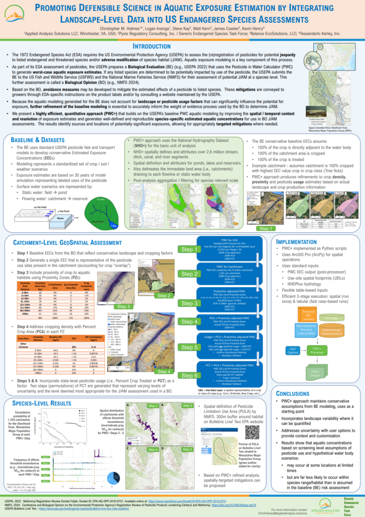
@misc{EU24PWC+,

title = {Promoting Defensible Science in Aquatic Exposure Estimation by Integrating Landscape-Level Data into US Endangered Species Assessments},

author = {Holmes, C.M. (Applied Analysis Solutions, LLC) and Insinga, L. (Applied Analysis Solutions, LLC) and Kay, S. (Pyxis Regulatory Consulting, Inc) and Kern, M. (Balance EcoSolutions, LLC) and Henry, K. (Tessenderlo Kerley, Inc.)},

url = {https://appliedanalysis.solutions/wp-content/uploads/2024/05/SETAC-EU-2024-PWCPlus.pdf, View Poster},

year  = {2024},

date = {2024-05-05},

urldate = {2024-05-05},

abstract = {Prospective aquatic exposure modeling is a key component of the assessment of potential jeopardy of endangered species during the preparation of a risk assessment related to federal US pesticide (re)registration. The “Biological Evaluation” prepared by the US Environmental Protection Agency (USEPA) provides the foundation of aquatic exposure estimates using well-established pesticide fate and transport models applied to a standardized set of crop/soil/weather scenarios. Exposure estimates are based on 30 years of model simulation representing labeled uses of the pesticide assuming maximum application rates, maximum number of applications, and minimum re-application intervals, as well as assuming treated crop is adjacent to the aquatic environment. This modeling forms the basis from which subsequent refinements incorporating spatial, temporal, and pesticide usage variability can be applied. Further refinement of the screening-level modeling is essential to more accurately inform the weight of evidence process used by the US Fish and Wildlife Service and National Marine Fisheries Service to determine species jeopardy in the next stage of the assessment, the “Biological Opinion”.

To support this refinement, we present a highly efficient, quantitative approach that builds on the USEPA’s aquatic modeling by increasing the spatial/temporal context and resolution of exposure estimates to species of interest and producing well-defined and reproducible species-specific estimated aquatic concentrations. Utilizing data for each species, a set of high-resolution catchments, landscape-based crop proximity and density, and pesticide usage, inputs were processed to produce landscape-level exposure concentrations suitable for aggregation at multiple spatial scales appropriate for the species being examined. These refinements show that aquatic concentrations based on screening level assumptions of pesticide use and hypothetical water body scenarios may occur at some locations at limited times, but they are far less likely to occur within species range/habitat than is assumed in the screening-level risk assessments.

The methodologies presented are a quantitative approach to refining aquatic exposure estimates that incorporate variations in landscape and agronomic practices near endangered species locations and provide essential information to help inform localized mitigations for individual species across specific use patterns.},

keywords = {2024, Poster, SETAC Europe},

pubstate = {published},

tppubtype = {presentation}

}
To support this refinement, we present a highly efficient, quantitative approach that builds on the USEPA’s aquatic modeling by increasing the spatial/temporal context and resolution of exposure estimates to species of interest and producing well-defined and reproducible species-specific estimated aquatic concentrations. Utilizing data for each species, a set of high-resolution catchments, landscape-based crop proximity and density, and pesticide usage, inputs were processed to produce landscape-level exposure concentrations suitable for aggregation at multiple spatial scales appropriate for the species being examined. These refinements show that aquatic concentrations based on screening level assumptions of pesticide use and hypothetical water body scenarios may occur at some locations at limited times, but they are far less likely to occur within species range/habitat than is assumed in the screening-level risk assessments.
The methodologies presented are a quantitative approach to refining aquatic exposure estimates that incorporate variations in landscape and agronomic practices near endangered species locations and provide essential information to help inform localized mitigations for individual species across specific use patterns.
Holmes, C.M. (Applied Analysis Solutions, LLC); Insinga, L. (Applied Analysis Solutions, LLC); Hodges, J. (Unilever Safety & Environmental Assurance Centre); Bietz, J. (Clariant Produkte GmbH); Beuter, L. (Nouryon AB); Schowanek, D. (Procter & Gamble); Dawich, J. (Innospec Limited); Maloney, E.M. (Shell Global Solutions International BV); Geurts, M. (Nouryon Chemicals B.V.); Wilhelm, S. (BASF Personal Care & Nutrition GbmH); Vitale, C.M. (Procter & Gamble); Anselmo, H. (Global Safety Assurance, Reckitt)
05.05.2024.
Abstract | Links | Tags: 2024, Poster, SETAC Europe
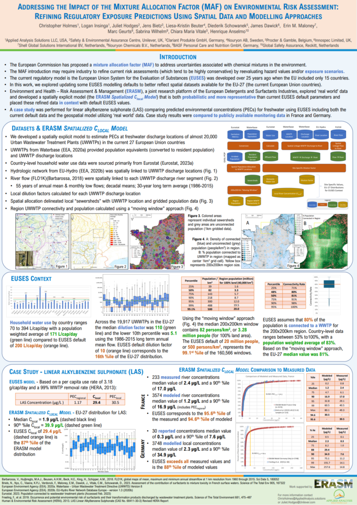
@misc{EU23MAF,

title = {Addressing the Impact of the Mixture Allocation Factor (MAF) on Environmental Risk Assessment: Refining Regulatory Exposure Predictions Using Spatial Data and Modelling Approaches},

author = {Holmes, C.M. (Applied Analysis Solutions, LLC) and Insinga, L. (Applied Analysis Solutions, LLC) and Hodges, J. (Unilever Safety & Environmental Assurance Centre) and Bietz, J. (Clariant Produkte GmbH) and Beuter, L. (Nouryon AB) and Schowanek, D. (Procter & Gamble) and Dawich, J. (Innospec Limited) and Maloney, E.M. (Shell Global Solutions International BV) and Geurts, M. (Nouryon Chemicals B.V.) and Wilhelm, S. (BASF Personal Care & Nutrition GbmH) and Vitale, C.M. (Procter & Gamble) and Anselmo, H. (Global Safety Assurance, Reckitt)},

url = {https://appliedanalysis.solutions/wp-content/uploads/2024/05/SETAC-EU-2024-ERASM-gridded-MAF.pdf, View Poster},

year  = {2024},

date = {2024-05-05},

urldate = {2024-05-05},

abstract = {Under the Chemical Strategy for Sustainability (CSS), the European Commission has proposed the use of a mixture allocation factor (MAF) to address uncertainties and risks associated with unintentional chemical mixtures in the environment. Currently it is thought that a MAF may need to be applied to all single chemical registrations for the higher tonnage bands. It is expected that additional exposure and/or effect data generation will be needed for the risk assessment, and in some cases further risk management measures may be required to ensure environmental safety.


The European Union System for the Evaluation of Substances (EUSES), also accessed via the CHESAR v1 tool is the standard model to determine exposure in support of chemical safety assessments (CSAs) under REACH. In the spirit of continuously refining safety assessments and models, we envisage an opportunity to update exposure model background data in EUSES/CHESAR in line with the evolution of wastewater treatment infrastructure in EU, and availability of better spatial datasets.  This would ensure that regulatory modelling remains aligned with most updated data available and the situation in the field.


In this work we explore field data and spatially explicit modelling approaches, some of which are probabilistic, in order to compare them with the current EUSES default parameters. We developed a spatially explicit model which applied the EUSES PEC calculation to estimate environmental concentrations at freshwater discharge locations of almost 22,000 European Urban Wastewater Treatment Plants (UWWTPs). Specifically, using publicly available data, we examined per capita water use, UWWTP connectivity and local UWWTP dilution factors to generate EU-wide distributions and to place these in context with default EUSES values.


We demonstrate that spatially explicit exposure models are feasible for use in regulatory modelling and can give more realistic predicted environmental concentrations (PECs). Case studies have been performed comparing PEClocal values for freshwater using CHESAR v1 including both the current default data and the spatial approach.  We expect that higher tier exposure data will be increasingly needed to ascertain that risk quotients remain acceptable even with a MAF applied.},

keywords = {2024, Poster, SETAC Europe},

pubstate = {published},

tppubtype = {presentation}

}
The European Union System for the Evaluation of Substances (EUSES), also accessed via the CHESAR v1 tool is the standard model to determine exposure in support of chemical safety assessments (CSAs) under REACH. In the spirit of continuously refining safety assessments and models, we envisage an opportunity to update exposure model background data in EUSES/CHESAR in line with the evolution of wastewater treatment infrastructure in EU, and availability of better spatial datasets. This would ensure that regulatory modelling remains aligned with most updated data available and the situation in the field.
In this work we explore field data and spatially explicit modelling approaches, some of which are probabilistic, in order to compare them with the current EUSES default parameters. We developed a spatially explicit model which applied the EUSES PEC calculation to estimate environmental concentrations at freshwater discharge locations of almost 22,000 European Urban Wastewater Treatment Plants (UWWTPs). Specifically, using publicly available data, we examined per capita water use, UWWTP connectivity and local UWWTP dilution factors to generate EU-wide distributions and to place these in context with default EUSES values.
We demonstrate that spatially explicit exposure models are feasible for use in regulatory modelling and can give more realistic predicted environmental concentrations (PECs). Case studies have been performed comparing PEClocal values for freshwater using CHESAR v1 including both the current default data and the spatial approach. We expect that higher tier exposure data will be increasingly needed to ascertain that risk quotients remain acceptable even with a MAF applied.
LaRoe, J. (Applied Analysis Solutions, LLC); Holmes, C.M. (Applied Analysis Solutions, LLC); Schad, T. (Bayer CropScience)
05.05.2024.
Abstract | Links | Tags: 2024, Poster, SETAC Europe
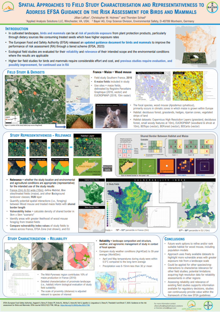
@misc{EU24birds,

title = {Spatial Approaches to Field Study Characterisation and Representativeness to Address EFSA Guidance on the Risk Assessment for Birds and Mammals},

author = {LaRoe, J. (Applied Analysis Solutions, LLC) and Holmes, C.M. (Applied Analysis Solutions, LLC) and Schad, T. (Bayer CropScience)},

url = {https://appliedanalysis.solutions/wp-content/uploads/2024/05/SETAC-EU-2024-Birds-and-mammals.pdf, View Poster},

year  = {2024},

date = {2024-05-05},

urldate = {2024-05-05},

abstract = {New EFSA guidance on the Risk assessment for Birds and Mammals includes updates relating to the improvement of terrestrial vertebrate (TV) field studies for use in risk assessment of Plant Protection Products containing pesticide active substances. Within the guidance, two concepts are discussed: Field Study Characterisation and Field Study Representativeness. To address these concepts, a past terrestrial vertebrate field study was assessed and updated to address the new guidance needs for characterisation and representativeness.


Field study characterisation involved collection and analysis of spatial data available for the study area and relevant to the species, including agricultural fields, grasslands, woody vegetation, forest, water/riparian areas. Percent area metrics were generated for several distances around the study fields, as well as examination of high-resolution imagery suitable for expert evaluation. Weather conditions during the field study were compared against 30-year monthly norms to verify the study year was not outside of expected variation from long-term averages.


Field study representativeness was assessed at multiple scales, including EU, EFSA zone and Member State. The potential for species interaction between “habitat” (a proxy defined by spatial land cover data) with “use sites” (assumed treated fields by crop type derived from agricultural maps) was processed using gridded spatial data at a resolution of 10m. Shared border between habitat and use sites served as an interaction indicator summarized at the 1-km scale (i.e., how many of the 10mx10m use site grid cells were adjacent to habitat cells). The 1-km scale is suitable for further aggregation at various sizes based on species attributes. In this case, local landscape interactions were assessed by developing “scenarios” a 5kmx5km summation of the interaction indicator which was quantified across all EU member states.


The scenario(s) encompassing the study fields were placed into the full distribution of all possible scenarios (EU, EFSA zone, Member State) to assess the study location relative to all possible use site / habitat interactions (i.e., possible field study locations). The quantitative approaches developed here can also be used to prepare upcoming generic terrestrial vertebrate field study designs and support optimized study site selection to meet the new EFSA guidance requirements.},

keywords = {2024, Poster, SETAC Europe},

pubstate = {published},

tppubtype = {presentation}

}
Field study characterisation involved collection and analysis of spatial data available for the study area and relevant to the species, including agricultural fields, grasslands, woody vegetation, forest, water/riparian areas. Percent area metrics were generated for several distances around the study fields, as well as examination of high-resolution imagery suitable for expert evaluation. Weather conditions during the field study were compared against 30-year monthly norms to verify the study year was not outside of expected variation from long-term averages.
Field study representativeness was assessed at multiple scales, including EU, EFSA zone and Member State. The potential for species interaction between “habitat” (a proxy defined by spatial land cover data) with “use sites” (assumed treated fields by crop type derived from agricultural maps) was processed using gridded spatial data at a resolution of 10m. Shared border between habitat and use sites served as an interaction indicator summarized at the 1-km scale (i.e., how many of the 10mx10m use site grid cells were adjacent to habitat cells). The 1-km scale is suitable for further aggregation at various sizes based on species attributes. In this case, local landscape interactions were assessed by developing “scenarios” a 5kmx5km summation of the interaction indicator which was quantified across all EU member states.
The scenario(s) encompassing the study fields were placed into the full distribution of all possible scenarios (EU, EFSA zone, Member State) to assess the study location relative to all possible use site / habitat interactions (i.e., possible field study locations). The quantitative approaches developed here can also be used to prepare upcoming generic terrestrial vertebrate field study designs and support optimized study site selection to meet the new EFSA guidance requirements.
2023
Holmes, C.M. (Applied Analysis Solutions, LLC); Pritsolas, J. (Southern Illinois University Edwardsville); Randall Pearson, R. (Southern Illinois University Edwardsville); Butts-Wilmsmeyer, C. (Southern Illinois University Edwardsville); Schad, T. (Bayer CropScience)
In: Applied Sciences, vol. 13, iss. 22, no. 12467, 2023.
Abstract | Links | Tags: 2023, Peer-Reviewed Publication
@article{timeseriesgrassland,

title = {Time-Series Characterization of Grassland Biomass Intensity to Examine Management Change at Two Sites in Germany Using 25 Years of Remote Sensing Imagery},

author = {Holmes, C.M. (Applied Analysis Solutions, LLC) and Pritsolas, J. (Southern Illinois University Edwardsville) and Randall Pearson, R. (Southern Illinois University Edwardsville) and Butts-Wilmsmeyer, C. (Southern Illinois University Edwardsville) and Schad, T. (Bayer CropScience)},

url = {https://www.mdpi.com/2076-3417/13/22/12467, View Online

https://appliedanalysis.solutions/wp-content/uploads/2023/12/Holmes-2023-Time-Series-Characterization-of-Grassland-Biomass-Intensity-to-Examine-Management-Change-at-Two-Sites-in-Germany-Using-25-Years-of-Remote-Sensing-Imagery.pdf, View Document},

doi = {10.3390/app132212467},

year  = {2023},

date = {2023-11-17},

urldate = {2023-11-17},

journal = {Applied Sciences},

volume = {13},

number = {12467},

issue = {22},

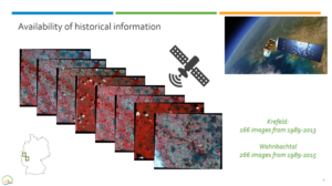
abstract = {In cultivated landscapes, grasslands are an important land use type for insect life. Grassland management practices can have a significant impact on insect ecology. For example, intense fertilization and frequent cutting can reduce the diversity and abundance of insects by destroying their habitat and food sources. Thus, the quality of grassland habitat for insect development depends on its management intensity. The intensification of grassland production is discussed as one factor contributing to the decline in insect biomass over recent decades. Characterizing grassland changes over time provides one piece to the larger puzzle of insect decline. We analyzed landscape-level trends in grassland biomass near Orbroich and Wahnbachtal in North Rhine-Westphalia, Germany, over a 25-year period. In both areas, pronounced insect biomass decline had been observed. More than 430 Landsat images were used. An image normalization process was developed and employed to ensure that observed changes over time were attributed to grassland changes and not systemic changes inherent within image time series. Distinct clusters of grassland parcels were identified based on intensity and temporal changes in biomass using Normalized Difference Vegetation Index (NDVI) as an indicator. Cluster separability was confirmed using the Transform Divergence method. The results showed clusters having periods of distinct trends in vegetation biomass, indicating changes in grassland agronomic and/or management practices over time (e.g., fertilization, increased silage production). Changes in management practices coincided with regional trends in cultivation as documented by official statistics. We demonstrated the feasibility of using 100+ images over multiple decades to perform a long-term remote sensing analysis examining grassland change. These temporally expansive and spatially detailed trends of grassland change can be included as factors in the multi-variate analysis of insect decline. The methodology can be applied to other geographic areas. Such improved insights can support informed landscape design and cultivation patterns in relation to insect ecology and the broader context of biodiversity enhancement.},

keywords = {2023, Peer-Reviewed Publication},

pubstate = {published},

tppubtype = {article}

}
Insinga, L. (Applied Analysis Solutions, LLC); Kay, S. (Pyxis Regulatory Consulting, Inc); Desmarteau, D. (Waterborne Environmental, Inc.)
10.10.2023.
Abstract | Links | Tags: 2023, EMPM, Presentation
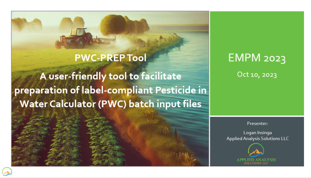
@misc{EMPM2023pwc,

title = {PWC-PREP Tool: A user-friendly tool to facilitate preparation of label-compliant Pesticide in Water Calculator (PWC) batch input files},

author = {Insinga, L. (Applied Analysis Solutions, LLC) and Kay, S. (Pyxis Regulatory Consulting, Inc) and Desmarteau, D. (Waterborne Environmental, Inc.) },

url = {https://appliedanalysis.solutions/wp-content/uploads/2024/05/EMPM-2023-PWC-Prep-Tool.pdf, View Presentation},

year  = {2023},

date = {2023-10-10},

urldate = {2023-10-10},

abstract = {The USEPA’s Pesticide in Water Calculator (PWC) simulates pesticide applications to land surfaces and subsequent transport to and fate in waterbodies.  When using PWC, one significant issue is accurately modeling pesticides as they typically have diverse uses and restrictions that vary based on the use site, region, and time of year.  These uses and restrictions are codified in the product label and can be highly interrelated with many permutations of potential applications. Therefore, defining conservative yet label-compliant use-patterns can be difficult and time consuming.  Failure to account for all labeled agronomic restrictions including total pesticide amount applied and number of application limitations on an annual and interval specific (e.g., pre-emergence or post-emergence) basis, as well as multiple application rates with rate-specific limitations (i.e., number of applications and temporal windows), minimum reapplication intervals, and pre-harvest intervals can lead to modeling of non-label-compliant or unrealistic application use patterns.  In addition, efforts to ensure modeling is conservative (e.g., simulation of applications during wettest months of the year for ESA assessments, or maximizing total amount applied in a year) can significantly complicate application date assignment logic.  To address these difficulties, the Generic Endangered Species Task Force (GESTF) has developed the PWC-PREP Tool to facilitate batch file preparation for PWC modeling.  Specifically, the PWC-PREP Tool features a robust algorithm that generates label-compliant application dates and rates for a wide variety of use sites, regions, and chemicals.  Leveraging a graphical user interface, the tool is highly configurable and allows the user to control modeling parameters related to application methods, drift factors, agronomic restrictions, and date-assignment. The PWC-PREP Tool to has been successfully used to efficiently parameterize a national set of PWC runs (n > 30,000) that follow label instructions in a manner that is transparent and can be repeated.},

keywords = {2023, EMPM, Presentation},

pubstate = {published},

tppubtype = {presentation}

}
Schad, T. (Bayer AG); Bub, S. (Rheinland‐Pfälzische Technische Universität); Wang, M. (WSC Scientific GmbH); Holmes, C.M. (Applied Analysis Solutions, LLC); Kleinmann, J. (WSC Scientific GmbH); Hammel, K. (Bayer AG); Ernst, G. (Bayer AG); Preuss, T.G. (Bayer AG)
A spatiotemporally explicit modeling approach for more realistic exposure and risk assessment of off‐field soil organisms Journal Article
In: Integrated Environmental Assessment and Management, vol. 20, iss. 1, pp. 263-278, 2023.
Abstract | Links | Tags: 2023, Peer-Reviewed Publication
@article{2023modeling,

title = {A spatiotemporally explicit modeling approach for more realistic exposure and risk assessment of off‐field soil organisms},

author = {Schad, T. (Bayer AG) and Bub, S. (Rheinland‐Pfälzische Technische Universität) and Wang, M. (WSC Scientific GmbH) and Holmes, C.M. (Applied Analysis Solutions, LLC) and Kleinmann, J. (WSC Scientific GmbH) and Hammel, K. (Bayer AG) and Ernst, G. (Bayer AG) and Preuss, T.G. (Bayer AG)},

url = {https://setac.onlinelibrary.wiley.com/doi/10.1002/ieam.4798, View Online

http://appliedanalysis.solutions/wp-content/uploads/2023/08/Schad-2023-IEAM-A-spatiotemporally-explicit-modeling-approach-for-more-realistic-exposure-and.pdf, View Document},

doi = {https://doi.org/10.1002/ieam.4798},

year  = {2023},

date = {2023-06-21},

urldate = {2023-06-21},

journal = {Integrated Environmental Assessment and Management},

volume = {20},

issue = {1},

pages = {263-278},

abstract = {Natural and seminatural habitats of soil living organisms in cultivated landscapes can be subject to unintended exposure

by active substances of plant protection products (PPPs) used in adjacent fields. Spray‐drift deposition and runoff are

considered major exposure routes into such off‐field areas. In this work, we develop a model (xOffFieldSoil) and associated

scenarios to estimate exposure of off‐field soil habitats. The modular model approach consists of components, each ad-

dressing a specific aspect of exposure processes, for example, PPP use, drift deposition, runoff generation and filtering,

estimation of soil concentrations. The approach is spatiotemporally explicit and operates at scales ranging from local edge‐

of‐field to large landscapes. The outcome can be aggregated and presented to the risk assessor in a way that addresses the

dimensions and scales defined in specific protection goals (SPGs). The approach can be used to assess the effect of

mitigation options, for example, field margins, in‐field buffers, or drift‐reducing technology. The presented provisional

scenarios start with a schematic edge‐of‐field situation and extend to real‐world landscapes of up to 5 km × 5 km. A case

study was conducted for two active substances of different environmental fate characteristics. Results are presented as a

collection of percentiles over time and space, as contour plots, and as maps. The results show that exposure patterns of off‐

field soil organisms are of a complex nature due to spatial and temporal variabilities combined with landscape structure and

event‐based processes. Our concepts and analysis demonstrate that more realistic exposure data can be meaningfully

consolidated to serve in standard‐tier risk assessments. The real‐world landscape‐scale scenarios indicate risk hot‐spots that

support the identification of efficient risk mitigation. As a next step, the spatiotemporally explicit exposure data can be

directly coupled to ecological effect models (e.g., for earthworms or collembola) to conduct risk assessments at biological

entity levels as required by SPGs. Integr Environ Assess Manag 2023;00:1–15. © 2023 Applied Analysis Solutions LLC and

WSC Scientific GmbH and Bayer AG and The Authors. Integrated Environmental Assessment and Management published by

Wiley Periodicals LLC on behalf of Society of Environmental Toxicology & Chemistry (SETAC)},

keywords = {2023, Peer-Reviewed Publication},

pubstate = {published},

tppubtype = {article}

}
by active substances of plant protection products (PPPs) used in adjacent fields. Spray‐drift deposition and runoff are
considered major exposure routes into such off‐field areas. In this work, we develop a model (xOffFieldSoil) and associated
scenarios to estimate exposure of off‐field soil habitats. The modular model approach consists of components, each ad-
dressing a specific aspect of exposure processes, for example, PPP use, drift deposition, runoff generation and filtering,
estimation of soil concentrations. The approach is spatiotemporally explicit and operates at scales ranging from local edge‐
of‐field to large landscapes. The outcome can be aggregated and presented to the risk assessor in a way that addresses the
dimensions and scales defined in specific protection goals (SPGs). The approach can be used to assess the effect of
mitigation options, for example, field margins, in‐field buffers, or drift‐reducing technology. The presented provisional
scenarios start with a schematic edge‐of‐field situation and extend to real‐world landscapes of up to 5 km × 5 km. A case
study was conducted for two active substances of different environmental fate characteristics. Results are presented as a
collection of percentiles over time and space, as contour plots, and as maps. The results show that exposure patterns of off‐
field soil organisms are of a complex nature due to spatial and temporal variabilities combined with landscape structure and
event‐based processes. Our concepts and analysis demonstrate that more realistic exposure data can be meaningfully
consolidated to serve in standard‐tier risk assessments. The real‐world landscape‐scale scenarios indicate risk hot‐spots that
support the identification of efficient risk mitigation. As a next step, the spatiotemporally explicit exposure data can be
directly coupled to ecological effect models (e.g., for earthworms or collembola) to conduct risk assessments at biological
entity levels as required by SPGs. Integr Environ Assess Manag 2023;00:1–15. © 2023 Applied Analysis Solutions LLC and
WSC Scientific GmbH and Bayer AG and The Authors. Integrated Environmental Assessment and Management published by
Wiley Periodicals LLC on behalf of Society of Environmental Toxicology & Chemistry (SETAC)
Holmes, C.M. (Applied Analysis Solutions, LLC); Maltby, L. (The University of Sheffield); Sweeney, P. (Syngenta); Thorbek, P. (BASF); Otte, J.C. (BASF); Marshall, S. (Consultant, UK)
04.30.2023.
Links | Tags: 2023, Poster, SETAC Europe
@misc{EU2023Heterogeneity,

title = {Heterogeneity in Biological Assemblages and Exposure in Chemical Risk Assessment: Exploring Capabilities and Challenges in Methodology with Two Landscape-Scale Case Studies},

author = {Holmes, C.M. (Applied Analysis Solutions, LLC) and Maltby, L. (The University of Sheffield) and Sweeney, P. (Syngenta) and Thorbek, P. (BASF) and Otte, J.C. (BASF) and Marshall, S. (Consultant, UK)},

url = {https://appliedanalysis.solutions/wp-content/uploads/2023/08/SETAC-EU-2023-4.01.P-Mo263-Geo-ref-TF.pdf, View Poster},

year  = {2023},

date = {2023-04-30},

urldate = {2023-04-30},

keywords = {2023, Poster, SETAC Europe},

pubstate = {published},

tppubtype = {presentation}

}
LaRoe, J. (Applied Analysis Solutions, LLC); Holmes, C.M. (Applied Analysis Solutions, LLC); Schad, T. (Bayer AG)
04.30.2023.
Links | Tags: 2023, Poster, SETAC Europe
@misc{2023EUScenario,

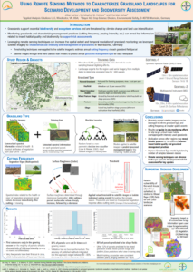
title = {Using Remote Sensing Methods to Characterize Grassland Landscapes for Scenario Development and Biodiversity Assessment},

author = {LaRoe, J. (Applied Analysis Solutions, LLC) and Holmes, C.M. (Applied Analysis Solutions, LLC) and Schad, T. (Bayer AG)},

url = {https://appliedanalysis.solutions/wp-content/uploads/2023/08/SETAC-EU-2023-GrasslandPoster-final.pdf, View Poster},

year  = {2023},

date = {2023-04-30},

urldate = {2023-04-30},

keywords = {2023, Poster, SETAC Europe},

pubstate = {published},

tppubtype = {presentation}

}
2022
LaRoe, J. (Applied Analysis Solutions, LLC); Holmes, C.M. (Applied Analysis Solutions, LLC); Schad, T. (Bayer AG)
11.13.2022.
Links | Tags: 2022, Poster, SETAC North America
@misc{NA2022Grassland,

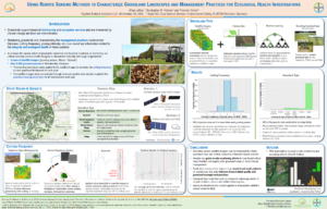
title = {Using Remote Sensing Methods to Characterize Grassland Landscapes and Management Practices for Ecological Health Investigations},

author = {LaRoe, J. (Applied Analysis Solutions, LLC) and Holmes, C.M. (Applied Analysis Solutions, LLC) and Schad, T. (Bayer AG)},

url = {https://appliedanalysis.solutions/wp-content/uploads/2023/08/SETAC-NA-2022-Characterize-Grassland.pdf, View Poster},

year  = {2022},

date = {2022-11-13},

urldate = {2022-11-13},

keywords = {2022, Poster, SETAC North America},

pubstate = {published},

tppubtype = {presentation}

}
LaRoe, J. (Applied Analysis Solutions, LLC)
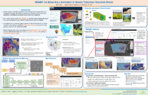
INHABIT for Broad-Scale Assessment of Invasive Terrestrial Vegetation Species Presentation
11.13.2022.
Links | Tags: 2022, Poster, SETAC North America
@misc{NA2022INHABIT,

title = {INHABIT for Broad-Scale Assessment of Invasive Terrestrial Vegetation Species},

author = {LaRoe, J. (Applied Analysis Solutions, LLC)},

url = {https://appliedanalysis.solutions/wp-content/uploads/2023/08/SETAC-NA-2022-INHABIT.pdf, View Poster},

year  = {2022},

date = {2022-11-13},

urldate = {2022-11-13},

keywords = {2022, Poster, SETAC North America},

pubstate = {published},

tppubtype = {presentation}

}
Holmes, C.M. (Applied Analysis Solutions, LLC); Schad, T. (Bayer AG); Preuss, T. (University of Koblenz-Landau, Germany)
Scenario Development for Bee Risk Assessment and Health Modelling Presentation
11.13.2022.
Links | Tags: 2022, Poster, SETAC North America
@misc{NA2022Bee,

title = {Scenario Development for Bee Risk Assessment and Health Modelling},

author = {Holmes, C.M. (Applied Analysis Solutions, LLC) and Schad, T. (Bayer AG) and Preuss, T. (University of Koblenz-Landau, Germany)},

url = {https://appliedanalysis.solutions/wp-content/uploads/2023/08/SETAC-NA-2022-BeeForage.pdf, View Poster},

year  = {2022},

date = {2022-11-13},

urldate = {2022-11-13},

keywords = {2022, Poster, SETAC North America},

pubstate = {published},

tppubtype = {presentation}

}
Holmes, C.M. (Applied Analysis Solutions, LLC); Desmarteau, D. (Waterborne Environmental, Inc.); Ritter, A. (Waterborne Environmental, Inc); Hendley, P. (Phasera Ltd.)
In: Journal of Regulatory Science, vol. 10, no. 1, 2022.
Abstract | Links | Tags: 2022, Peer-Reviewed Publication, Submitted
@article{cropProximity2022,

title = {A national probabilistic characterization of local crop proximity and density for refining US screening level exposure estimates of pesticides in surface water arising from agricultural use},

author = {Holmes, C.M. (Applied Analysis Solutions, LLC) and Desmarteau, D. (Waterborne Environmental, Inc.) and Ritter, A. (Waterborne Environmental, Inc) and Hendley, P. (Phasera Ltd.)},

url = {https://regsci-ojs-tamu.tdl.org/regsci/article/view/216, View Online

http://appliedanalysis.solutions/wp-content/uploads/2023/01/Holmes2023_A_national_probabilistic_characterization_of_local_crop_proximity_and_density_for_refining_US_screening_level_exposure_estimates.pdf, View Document

http://appliedanalysis.solutions/wp-content/uploads/2023/01/Holmes2023_SupplementaryInformation_A_national_probabilistic_characterization_of_local_crop_proximity_and_density.pdf, View Supplementary Information},

doi = {10.21423/jrs-v10a216},

year  = {2022},

date = {2022-10-26},

urldate = {2022-10-26},

journal = {Journal of Regulatory Science},

volume = {10},

number = {1},

abstract = {Rising world population and changing diets are increasing the need for efficient and effective food and fiber production. Pesticides are used across the US to control pests and improve food yield and quality, but these benefits are offset by their potential to reach and possibly impact aquatic or terrestrial ecosystems. Regulatory agencies rely on prospective exposure models that often start with conservative simplifying assumptions that are refined with additional information if needed. The USEPA ecological risk assessment framework for pesticides assumes, at screening level, that 100% of the area draining to a water body is cropped. However, at the grower’s real-world scale, this simplifying assumption is generally not realistic and should be refined for higher tier assessment. The present study developed a US-wide spatially explicit analysis of crop density and proximity to surface waters to characterize the potential for pyrethroid insecticides to enter flowing surface waters. Reliable, transparent, and publicly available government spatial cropping and hydrology datasets were employed at the catchment-scale across the full extent of agricultural production in the US were used to generate fifteen novel crop-specific probabilistic distributions describing the extent and proximity of each crop to the flowing water body defining small catchments. These were used to refine estimated environmental concentrations using USEPA standard regulatory scenarios to evaluate the importance of considering agricultural landscapes when refining aquatic pesticide concentrations. Incorporating these real-world probabilities of crop occurrence and proximity showed that, while potential maximal aquatic exposure concentrations are unchanged, the probability of exceeding regulatory decision-making concentration endpoints is much lower than predicted by standard assumptions (e.g., 1.9 to ~50-fold reductions by crop for 90% of catchments). Additionally, we show that the relative ranking of crops by their aquatic pesticide exposure potential may change from that indicated when cropping density and proximity are considered.},

keywords = {2022, Peer-Reviewed Publication, Submitted},

pubstate = {published},

tppubtype = {article}

}
Holmes, C.M. (Applied Analysis Solutions, LLC); Maltby, L. (The University of Sheffield); Sweeney, P. (Syngenta); Thorbek, P. (BASF); Otte, J.C. (BASF); Marshall, S. (Consultant, UK)
Heterogeneity in biological assemblages and exposure in chemical risk assessment: two landscape-scale case studies Journal Article
In: Ecotoxicology and Environmental Safety, vol. 246, pp. 114143, 2022.
Abstract | Links | Tags: 2022, Peer-Reviewed Publication
@article{Holmes2022,

title = {Heterogeneity in biological assemblages and exposure in chemical risk assessment: two landscape-scale case studies},

author = {Holmes, C.M. (Applied Analysis Solutions, LLC) and Maltby, L. (The University of Sheffield) and Sweeney, P. (Syngenta) and Thorbek, P. (BASF) and Otte, J.C. (BASF) and Marshall, S. (Consultant, UK)},

url = {https://www.sciencedirect.com/science/article/pii/S0147651322009836, View Online

http://appliedanalysis.solutions/wp-content/uploads/2023/01/Holmes_2022_Heterogeneity-in-biological-assemblages-and-exposure-in-chemical-risk-assessment.pdf, View Document

https://appliedanalysis.solutions/wp-content/uploads/2023/01/Holmes_2022_SI_Heterogeneity-in-biological-assemblages-and-exposure-in-chemical-risk-assessment.pdf, View Supplemental Information},

doi = {10.1016/j.ecoenv.2022.114143},

year  = {2022},

date = {2022-10-03},

urldate = {2022-10-03},

journal = {Ecotoxicology and Environmental Safety},

volume = {246},

pages = {114143},

abstract = {Current prospective chemical risk assessment frameworks do not directly address the landscape-scale heterogeneity of exposure and ecological receptors because they assume that reasonably worst-case chemical exposure concentrations co-occur, spatially and temporally, with species assemblages that are most sensitive to the chemical’s toxicity. Whilst current approaches aim to be protective, a more precise understanding of when and where exposure and species co-occur enables risk assessments to be better tailored and mitigation made more efficient.  We use two aquatic case studies covering different spatial and temporal resolution to explore how geo-referenced data and spatial tools might be used to account for landscape heterogeneity of exposure and receptors in prospective risk assessment. We investigate how distributions of spatially referenced chemical exposure and ecological assemblages can be integrated to assess and interpret risk with each case study following a stepwise approach: i) estimate and establish spatial exposure distributions; ii) derive toxicity thresholds for various taxonomic groups and determine geo-referenced distributions of exposure-toxicity ratios, i.e. potential risk; iii) overlay risk data with the ecological status of the European Union’s Water Framework Directive biomonitoring sites to determine if relationships exist. We focus on demonstrating whether integration of relevant data and potential approaches was feasible rather than making comprehensive and refined assessments of specific chemicals.  The studies indicate that geo-referenced predicted environmental concentration estimations  can be achieved with available data, models and tools but establishing the distribution of species assemblages is limited by availability of biomonitoring data and fewer tools. The studies highlight the important influence that choices for aggregating data and for the selection of statistical metrics have on assessing and interpreting risk at different spatial scales and patterns of distribution within the landscape. Finally, we discuss approaches that could help to address environmental heterogeneity in chemical risk assessment.},

keywords = {2022, Peer-Reviewed Publication},

pubstate = {published},

tppubtype = {article}

}
LaRoe, J. (Applied Analysis Solutions, LLC); Holmes, C.M. (Applied Analysis Solutions, LLC); Schad, T. (Bayer AG)
Nightlight Intensity Change Surrounding Nature Reserves: A Case Study in Orbroicher Bruch Nature Reserve, Germany Journal Article
In: Remote Sensing, vol. 14, iss. 16, no. 3876, pp. 1-19, 2022.
Abstract | Links | Tags: 2022, Peer-Reviewed Publication, Remote Sensing
@article{nokeyb,

title = {Nightlight Intensity Change Surrounding Nature Reserves: A Case Study in Orbroicher Bruch Nature Reserve, Germany },

author = {LaRoe, J. (Applied Analysis Solutions, LLC) and Holmes, C.M. (Applied Analysis Solutions, LLC) and Schad, T. (Bayer AG)},

url = {https://www.mdpi.com/2072-4292/14/16/3876, View Online

https://appliedanalysis.solutions/wp-content/uploads/2023/01/LaRoe-2022-Nightlight-Intensity-Change-Surrounding-Nature-Reserves-A-Case-Study-in-Orbroicher-Bruch-Nature-Reserve-Germany.pdf, View Document},

doi = {10.3390/rs14163876},

year  = {2022},

date = {2022-08-10},

urldate = {2022-08-10},

journal = {Remote Sensing},

volume = {14},

number = {3876},

issue = {16},

pages = {1-19},

abstract = {This article belongs to the Special Issue Remote Sensing of Night-Time Light.


Persistent global urbanization has a direct relationship to measurable artificial light at night (ALAN), and the Defense Meteorological Satellite Program has served an important role in monitoring this relationship over time. Recent studies have observed significant declines in insect abundance and populations, and ALAN has been recognized as a contributing factor. We inves-tigated changes in nightlight intensity at various spatial scales surrounding insect traps located in Orbroicher Bruch Nature Reserve, Germany. Using a time series of global nighttime light imagery (1992–2010), we evaluated pixel-level trends through linear regressions and the Mann–Kendall test. Paired with urban land cover delineation, we compared nightlight trends across rural and urban areas. We utilized high-resolution satellite imagery to identify landscape features poten-tially related to pixel-level trends within areas containing notable change. Approximately 96% of the pixel-level trends had a positive slope, and 22% of pixels experienced statistically significant increases in nightlight intensity. We observed that 80% of the region experienced nightlight in-tensity increases >1%, concurrent with the observed decline in insect biomass. While it is unclear if these trends extend to other geographic regions, our results highlight the need for future studies to concurrently investigate long-term trends in ALAN and insect population decline across multiple scales, and consider the spatial and temporal overlaps between these patterns.},

keywords = {2022, Peer-Reviewed Publication, Remote Sensing},

pubstate = {published},

tppubtype = {article}

}
Persistent global urbanization has a direct relationship to measurable artificial light at night (ALAN), and the Defense Meteorological Satellite Program has served an important role in monitoring this relationship over time. Recent studies have observed significant declines in insect abundance and populations, and ALAN has been recognized as a contributing factor. We inves-tigated changes in nightlight intensity at various spatial scales surrounding insect traps located in Orbroicher Bruch Nature Reserve, Germany. Using a time series of global nighttime light imagery (1992–2010), we evaluated pixel-level trends through linear regressions and the Mann–Kendall test. Paired with urban land cover delineation, we compared nightlight trends across rural and urban areas. We utilized high-resolution satellite imagery to identify landscape features poten-tially related to pixel-level trends within areas containing notable change. Approximately 96% of the pixel-level trends had a positive slope, and 22% of pixels experienced statistically significant increases in nightlight intensity. We observed that 80% of the region experienced nightlight in-tensity increases >1%, concurrent with the observed decline in insect biomass. While it is unclear if these trends extend to other geographic regions, our results highlight the need for future studies to concurrently investigate long-term trends in ALAN and insect population decline across multiple scales, and consider the spatial and temporal overlaps between these patterns.
Ritter, A. (Waterborne Environmental, Inc); Desmarteau, D. (Waterborne Environmental, Inc.); Hendley, P. (Phasera Ltd.); Holmes, C.M. (Applied Analysis Solutions, LLC)
National characterization of pesticide runoff and erosion potential to put USEPA standard ecological scenarios in context for pyrethroids Journal Article
In: Integrated Environmental Assessment and Management, vol. 00, no. 00, pp. 1-16, 2022.
Abstract | Links | Tags: 2022, Peer-Reviewed Publication
@article{nokey,

title = {National characterization of pesticide runoff and erosion potential to put USEPA standard ecological scenarios in context for pyrethroids},

author = {Ritter, A. (Waterborne Environmental, Inc) and Desmarteau, D. (Waterborne Environmental, Inc.) and Hendley, P. (Phasera Ltd.) and Holmes, C.M. (Applied Analysis Solutions, LLC)},

url = {https://setac.onlinelibrary.wiley.com/doi/10.1002/ieam.4647,  Online Publication

https://appliedanalysis.solutions/wp-content/uploads/2022/07/Integr-Envir-Assess-Manag-2022-Ritter-National-characterization-of-pesticide-runoff-and-erosion-potential-to-put.pdf, View document},

doi = {10.1002/ieam.4647},

year  = {2022},

date = {2022-06-09},

urldate = {2022-06-09},

journal = {Integrated Environmental Assessment and Management},

volume = {00},

number = {00},

pages = {1-16},

abstract = {Decision-making for pesticide registration by the US Environmental Protection Agency (USEPA) relies upon crop-specific scenarios in a tiered framework. These standard modeling scenarios are stated to represent “…sites expected to produce runoff greater than would be expected at 90% of the sites for a given crop/use.” This study developed a novel approach to compare the pesticide runoff + erosion (SumRE) mass flux potential of a hydrophobic chemical using 36 of these ecological regulatory scenarios with national-scale distributions of modeled SumRE from over 750 000 USA-wide agricultural catchments to provide real-world context for the simulated transport predictions used for regulatory decision-making. For the standard scenarios and national scale modeling, “edge of field” SumRE mass flux was estimated using regulatory guidance for a hypothetical pyrethroid. The national-scale simulations were developed using publicly available soil, hydrography, and crop occurrence /regional timings databases. Relevant soil and crop combinations identified by spatial overlay along with weather data were used in a regulatory model to generate daily SumRE estimates, which were assigned to the catchments. The resulting average annual total SumRE mass fluxes were ranked to produce distributions to compare with the standard regulatory scenario outputs. These comparisons showed that SumRE flux from 25 of the 36 USEPA ecological regulatory crop-specific scenarios modeled ranked above the 99th percentile of pyrethroid runoff + erosion vulnerability from any catchment growing that crop; SumRE flux from six scenarios was more severe than any catchment. For 12 USEPA regulatory scenarios, the resulting eroded sediment corresponds to highly erodible land (HEL), which the US Department of Agriculture mandates should not be cropped without substantial additional erosion prevention controls for sustainability. Since the pesticide regulatory framework already incorporates many acknowledged assumptions to ensure it conservatively meets protection goals, these HEL observations suggest that the standard scenarios overestimate potential aquatic exposure and that the regulatory process is more protective than intended. Integr Environ Assess Manag 2022;00:1–16. © 2022 The Authors. Integrated Environmental Assessment and Management published by Wiley Periodicals LLC on behalf of Society of Environmental Toxicology & Chemistry (SETAC).},

keywords = {2022, Peer-Reviewed Publication},

pubstate = {published},

tppubtype = {article}

}
Miglino, A.N. (U.S. Food & Drug Administration); Holmes, C.M. (Applied Analysis Solutions, LLC)
Applying weight of evidence methods to assessing exposure in aquatic environments: Comparing lines of evidence Journal Article
In: Integrated Environmental Assessment and Management, 2022.
Abstract | Links | Tags: 2022, Peer-Reviewed Publication
@article{WeightOfEvidence2022,

title = {Applying weight of evidence methods to assessing exposure in aquatic environments: Comparing lines of evidence},

author = {Miglino, A.N. (U.S. Food & Drug Administration) and Holmes, C.M. (Applied Analysis Solutions, LLC)},

url = {https://setac.onlinelibrary.wiley.com/doi/10.1002/ieam.4602, View online},

doi = { https://doi.org/10.1002/ieam.4602},

year  = {2022},

date = {2022-03-07},

urldate = {2022-03-07},

journal = {Integrated Environmental Assessment and Management},

abstract = {This article is part of the special series “Practical Considerations for Application of Weight of Evidence (WoE) in Chemical Evaluations” and was generated in part from several SETAC-sponsored workshops and symposia organized between 2015 and 2019. These included symposia in each of the SETAC Geographic Units as well as a Pellston Workshop on data usability. This series aims to reflect the broad applicability of WoE methodology in environmental risk assessment for chemical evaluations when combined with a classic tiered assessment approach, applicable regardless of regulatory structures. The articles discuss transparent mechanisms for communicating decision-making processes and critically examine case studies that lay out a guide for implementing WoE for improving chemical evaluations to increase their acceptability by regulators, risk managers, NGOs, and other stakeholders for desired protection goals.


Weight of evidence (WoE) is a useful approach to quantifying the relative relevance, strength, reliability, and uncertainty associated with estimates of exposure concentrations. WoE is often used in exposure assessments but rarely explored or discussed in detail. In this article, the utility of a WoE approach in aquatic exposure assessments is illustrated via two case studies using a tiered approach and the chemical triclosan. Each case study evaluates the same chemical and pathway to the environment but with substantially different data strength, reliability, and uncertainty. The collection and qualitative evaluation of relevant lines of evidence (LoE) using a three-tiered approach are discussed. Our results demonstrate how a higher tiered WoE approach can reduce uncertainty and improve decision-making based on predicted exposure concentrations. We also identify LoE that played a significant role in the final exposure determinations and describe a framework for conducting exposure assessments using WoE. Integr Environ Assess Manag 2022;00:1–13. © 2022 SETAC},

keywords = {2022, Peer-Reviewed Publication},

pubstate = {published},

tppubtype = {article}

}
Weight of evidence (WoE) is a useful approach to quantifying the relative relevance, strength, reliability, and uncertainty associated with estimates of exposure concentrations. WoE is often used in exposure assessments but rarely explored or discussed in detail. In this article, the utility of a WoE approach in aquatic exposure assessments is illustrated via two case studies using a tiered approach and the chemical triclosan. Each case study evaluates the same chemical and pathway to the environment but with substantially different data strength, reliability, and uncertainty. The collection and qualitative evaluation of relevant lines of evidence (LoE) using a three-tiered approach are discussed. Our results demonstrate how a higher tiered WoE approach can reduce uncertainty and improve decision-making based on predicted exposure concentrations. We also identify LoE that played a significant role in the final exposure determinations and describe a framework for conducting exposure assessments using WoE. Integr Environ Assess Manag 2022;00:1–13. © 2022 SETAC
2021
Holmes, C.M. (Applied Analysis Solutions, LLC); Insinga, L. (Applied Analysis Solutions, LLC); Sweeney, P. (Syngenta); Loiseau, L. (Syngenta AG); Johnson, D. (Syngenta)
Comprehensive Characterization of Agricultural Proximity to Surface Water in France Presentation
05.02.2021.
Links | Tags: 2021, Presentation, SETAC Europe
@misc{2021EUFR,

title = {Comprehensive Characterization of Agricultural Proximity to Surface Water in France},

author = {Holmes, C.M. (Applied Analysis Solutions, LLC) and Insinga, L. (Applied Analysis Solutions, LLC) and Sweeney, P. (Syngenta) and Loiseau, L. (Syngenta AG) and Johnson, D. (Syngenta)},

url = {https://appliedanalysis.solutions/wp-content/uploads/2020/12/SETAC-EU-2021-FRmaize-extended-abstract.pdf, Extended abstract

https://appliedanalysis.solutions/wp-content/uploads/2021/06/SETAC-EU-2021-FR-proximity-final.pdf, Presentation slides

https://youtu.be/I2DOn-g2UeY, Presentation video

},

year  = {2021},

date = {2021-05-02},

urldate = {2021-05-02},

organization = {Syngenta, Jeallot’s Hill, Bracknell, UK},

keywords = {2021, Presentation, SETAC Europe},

pubstate = {published},

tppubtype = {presentation}

}
Holmes, C.E. (Virginia Polytechnic Institute & State University); Löw, F.; Schad, T. (Bayer CropScience); Holmes, C.M. (Applied Analysis Solutions, LLC)
05.02.2021.
Links | Tags: 2021, Presentation, SETAC Europe
@misc{2021EUEarthEE,

title = {Landscape Characterization with Google Earth Engine: Functionality Supporting High Resolution Spatiotemporal Analyses Using Satellite Imagery},

author = {Holmes, C.E. (Virginia Polytechnic Institute & State University) and Löw, F. and Schad, T. (Bayer CropScience) and Holmes, C.M. (Applied Analysis Solutions, LLC)},

url = {https://appliedanalysis.solutions/wp-content/uploads/2021/09/SETAC-EU-2021-Earth-Engine-extended-abstract-final.pdf, Extended abstract

https://www.youtube.com/watch?v=QsUPxFrjZos, Presentation video},

year  = {2021},

date = {2021-05-02},

urldate = {2021-05-02},

keywords = {2021, Presentation, SETAC Europe},

pubstate = {published},

tppubtype = {presentation}

}
Holmes, C.M. (Applied Analysis Solutions, LLC); Pritsolas, J. (Southern Illinois University Edwardsville); Pearson, R. (Southern Illinois University Edwardsville); Butts-Wilmsmeyer, C. (Southern Illinois University Edwardsville); Schad, T. (Bayer CropScience)
Grassland Management Change Over 25 Years: A Landscape Analysis Using Remote Sensing Presentation
05.02.2021.
Links | Tags: 2021, Presentation, SETAC Europe
@misc{2021EUGrass,

title = {Grassland Management Change Over 25 Years: A Landscape Analysis Using Remote Sensing},

author = {Holmes, C.M. (Applied Analysis Solutions, LLC) and Pritsolas, J. (Southern Illinois University Edwardsville) and Pearson, R. (Southern Illinois University Edwardsville) and Butts-Wilmsmeyer, C. (Southern Illinois University Edwardsville) and Schad, T. (Bayer CropScience)},

url = {https://appliedanalysis.solutions/wp-content/uploads/2020/12/SETAC-EU-2021-Grassland-extended-abstract.pdf, Extended abstract

https://www.youtube.com/watch?v=EZ-WS-4W-BY, Presentation video},

year  = {2021},

date = {2021-05-02},

urldate = {2021-05-02},

keywords = {2021, Presentation, SETAC Europe},

pubstate = {published},

tppubtype = {presentation}

}
Holmes, C.M. (Applied Analysis Solutions, LLC); Marshall, S. (Consultant, UK); Maltby, L. (The University of Sheffield); Sweeney, P. (Syngenta); Thorbek, P. (BASF); Otte, J.C. (BASF)
05.02.2021.
Links | Tags: 2021, Poster, Presentation, SETAC Europe
@misc{2021EU2study,

title = {Increasing Ecological Relevance of Chemical Risk Assessments Using Geospatial Approaches: Results From Two Case Studies},

author = {Holmes, C.M. (Applied Analysis Solutions, LLC) and Marshall, S. (Consultant, UK) and Maltby, L. (The University of Sheffield) and Sweeney, P. (Syngenta) and Thorbek, P. (BASF) and Otte, J.C. (BASF)},

url = {https://appliedanalysis.solutions/wp-content/uploads/2020/12/SETAC-EU-2021-ECETOC-extended-abstract.pdf, Extended abstract

https://appliedanalysis.solutions/wp-content/uploads/2021/06/SETAC-EU-2021-ECETOC-platform-final.pdf, Presentation slides

https://appliedanalysis.solutions/wp-content/uploads/2021/06/SETAC-EU-2021-ECETOC-platform-final.pdf, Surfactant case study poster

https://appliedanalysis.solutions/wp-content/uploads/2021/06/SETAC-EU-2021-ECETOC-PPP-case-study-poster-final.pdf, PPP case study poster

https://www.youtube.com/watch?v=ZdxQrdubIs8, Presentation video},

year  = {2021},

date = {2021-05-02},

urldate = {2021-05-02},

keywords = {2021, Poster, Presentation, SETAC Europe},

pubstate = {published},

tppubtype = {presentation}

}
Holmes, C.M. (Applied Analysis Solutions, LLC); Tandy, E. (Applied Analysis Solutions, LLC); Schleicher, Z. (Southern Illinois University, Edwardsville); Kilgallon, J. (Unilever Safety & Environmental Assurance Centre); Hodges, J. (Unilever Safety & Environmental Assurance Centre)
2021.
Links | Tags: 2021, Poster, SETAC Europe
@conference{2021Marine,

title = {Estimating Domestic Wastewater Emissions to Marine Environments Using a Spatial Extrapolation Approach},

author = {Holmes, C.M. (Applied Analysis Solutions, LLC) and Tandy, E. (Applied Analysis Solutions, LLC) and Schleicher, Z. (Southern Illinois University, Edwardsville) and Kilgallon, J. (Unilever Safety & Environmental Assurance Centre) and Hodges, J. (Unilever Safety & Environmental Assurance Centre)},

url = {https://appliedanalysis.solutions/wp-content/uploads/2021/06/SETAC-EU-2021-Marine-emission-poster-final.pdf, View poster},

year  = {2021},

date = {2021-05-02},

urldate = {2021-05-02},

keywords = {2021, Poster, SETAC Europe},

pubstate = {published},

tppubtype = {conference}

}
Holmes, C.M. (Applied Analysis Solutions, LLC)
Prospective Modelling of Microplastic Exposure in Freshwater Systems Presentation
03.25.2021.
Abstract | Links | Tags: 2021, Presentation, SETAC Virtual Seminars
@misc{2021Micro,

title = {Prospective Modelling of Microplastic Exposure in Freshwater Systems},

author = {Holmes, C.M. (Applied Analysis Solutions, LLC)},

url = {https://appliedanalysis.solutions/wp-content/uploads/2021/06/SETAC-MP-Seminar-4-Holmes-Freshwater-modeling-of-MPs.pdf, View Presentation},

year  = {2021},

date = {2021-03-25},

urldate = {2021-03-25},

abstract = {Understanding the sources, emissions and environmental fate of plastics is a challenge being examined in parallel with empirical methods of microplastic detection, characterization and quantification. Freshwater systems are increasingly being identified as significant sources of microplastics within the marine environment. Plastics can enter freshwater systems from many sources, such as direct emission (e.g., watsewater treatment plants), via runoff from land surfaces (e.g., urban stormwater, road washoff, agricultural land), air deposition, and direct entry of macroplastics from mismanaged waste/recycling. This presentation will discuss aspects related to the entry, fate and transport of microplastics in riverine environments, and how prospective exposure modelling can help provide information to support subsequent exposure and risk assessment. The scientific body of knowledge related to microplastic exposure, effects and potential risk continues to expand. And as with management of other substances entering the environment, good science should be our guiding principle to inform any decision making process.},

keywords = {2021, Presentation, SETAC Virtual Seminars},

pubstate = {published},

tppubtype = {presentation}

}
2020
Holmes, C.M. (Applied Analysis Solutions, LLC); Pearson, R. (Southern Illinois University Edwardsville); Pritsolas, J. (Southern Illinois University Edwardsville); Butts-Wilmsmeyer, C. (Southern Illinois University Edwardsville); Schad, T. (Bayer CropScience)
Informing Effects Modeling Using Historic Changes in Habitat Derived from Remote Sensing Presentation
11.15.2020.
Abstract | Links | Tags: 2020, Presentation, SETAC North America
@misc{2020NAIE,

title = {Informing Effects Modeling Using Historic Changes in Habitat Derived from Remote Sensing},

author = {Holmes, C.M. (Applied Analysis Solutions, LLC) and Pearson, R. (Southern Illinois University Edwardsville) and Pritsolas, J. (Southern Illinois University Edwardsville) and Butts-Wilmsmeyer, C. (Southern Illinois University Edwardsville) and Schad, T. (Bayer CropScience)},

url = {https://www.youtube.com/watch?v=vvEMOeC50mw, Presentatio video},

year  = {2020},

date = {2020-11-15},

urldate = {2020-11-15},

abstract = {Ecological effects modeling for population or community level environmental risk assessment seeks to describe the interactions of biological, chemical, environmental and anthropogenic factors in relation to stressor-response relationships. Changes in landscape over time can play a large role in habitat suitability and species occurrence, important aspects in population-level modeling. Landscape change can be assessed from retrospective analyses or predictive efforts based on models or assumptions.


This presentation describes novel remote sensing image processing methods used to capture landscape-level changes in grassland extent and management within a 300 km2 area over a 25-year period near Krefeld, Germany. Over 150 satellite images were acquired from NOAA’s Landsat program spanning 1989 to 2013 from all seasons. Images within each year were normalized for atmospheric and illumination variation to focus on vegetation changes due to plant structure and vigor using different vegetation indices based on visible and infra-red wavelengths.


Four groups of grassland fields were identified using a k-means clustering algorithm based on spectral information. In several groups, periods of distinct increase in vegetation biomass (defined by vegetation indices) could indicate changes in grassland management practices over that time from natural grassland cycles to include more intensive management activities (e.g., fertilization, more frequent cutting, silage production). Other groups showed relative consistency across time.


All data used in this study are geographically referenced and processed in a Geographic Information System (GIS). These data are suitable for spatially-explicit landscape-level ecological modeling efforts exploring the multitude of stressors that may impact biological communities over time. This is especially important for retrospective modeling studies where ecological models are used to explain empirically derived data over time (e.g., sampling of insect counts and biomass). Grassland areas are important habitat for some groups of insects and understanding historic changes in grassland extent and management provides a key factor in the study of landscape-level ecological effects modeling. We have demonstrated the feasibility and applicability of utilizing information from freely available satellite image archives for habitat characterization of historic landscape patterns and changes over a 25-year period.},

keywords = {2020, Presentation, SETAC North America},

pubstate = {published},

tppubtype = {presentation}

}
This presentation describes novel remote sensing image processing methods used to capture landscape-level changes in grassland extent and management within a 300 km2 area over a 25-year period near Krefeld, Germany. Over 150 satellite images were acquired from NOAA’s Landsat program spanning 1989 to 2013 from all seasons. Images within each year were normalized for atmospheric and illumination variation to focus on vegetation changes due to plant structure and vigor using different vegetation indices based on visible and infra-red wavelengths.
Four groups of grassland fields were identified using a k-means clustering algorithm based on spectral information. In several groups, periods of distinct increase in vegetation biomass (defined by vegetation indices) could indicate changes in grassland management practices over that time from natural grassland cycles to include more intensive management activities (e.g., fertilization, more frequent cutting, silage production). Other groups showed relative consistency across time.
All data used in this study are geographically referenced and processed in a Geographic Information System (GIS). These data are suitable for spatially-explicit landscape-level ecological modeling efforts exploring the multitude of stressors that may impact biological communities over time. This is especially important for retrospective modeling studies where ecological models are used to explain empirically derived data over time (e.g., sampling of insect counts and biomass). Grassland areas are important habitat for some groups of insects and understanding historic changes in grassland extent and management provides a key factor in the study of landscape-level ecological effects modeling. We have demonstrated the feasibility and applicability of utilizing information from freely available satellite image archives for habitat characterization of historic landscape patterns and changes over a 25-year period.
Kern, M. (Balance EcoSolutions, LLC); Holmes, C.M. (Applied Analysis Solutions, LLC); Kay, S. (Pyxis Regulatory Consulting, Inc); Cowles, J. (Tessenderlo Kerley, Inc.); Henry, K. (Tessenderlo Kerley, Inc.)
Advancing Beyond the Draft Biological Evaluation of Carbaryl for Federally Listed Species Presentation
11.15.2020.
Abstract | Links | Tags: 2020, Presentation, SETAC North America
@misc{2020NAAB,

title = {Advancing Beyond the Draft Biological Evaluation of Carbaryl for Federally Listed Species},

author = {Kern, M. (Balance EcoSolutions, LLC) and Holmes, C.M. (Applied Analysis Solutions, LLC) and Kay, S. (Pyxis Regulatory Consulting, Inc) and Cowles, J. (Tessenderlo Kerley, Inc.) and Henry, K. (Tessenderlo Kerley, Inc.)},

url = {https://www.youtube.com/watch?v=Pw_V_MXP3f8, Presentation video},

year  = {2020},

date = {2020-11-15},

urldate = {2020-11-15},

abstract = {The Endangered Species Act (ESA) requires federal agencies to ensure that their actions are not likely to jeopardize the continued existence, nor destroy or adversely modify the designated critical habitat, of species listed as threatened or endangered under the ESA. For pesticides, a Biological Evaluation (BE) is conducted by the EPA as a first step in the ESA assessment.  If EPA’s BE determines a pesticide may affect a listed species or its designated critical habitat, EPA must initiate consultation with the U.S. Fish and Wildlife Service and/or the National Marine Fisheries Service (Services) depending on which agency has jurisdiction over the species.


On March 17, 2020, EPA posted to the Federal Register (FRL-10006-38) the release of their draft Biological Evaluation (BE) assessing potential risks to listed species from labeled uses of carbaryl. In parallel, the EPA posted a Revised Method document (EPA-HQ-OPP-2019-0195) detailing updated methods for conducting a BE. The revised methods include the use of actual pesticide usage data and distribution of treated acres, alternate assumptions for species population numbers, probabilistic approaches, and a weight-of-evidence framework for making effect determinations.    As noted in the BE, the methods used in these analyses continue to evolve over time.


To further support this advancement, case studies implementing the Revised Methods were conducted to understand and evaluate the approaches used in the draft BE for carbaryl.  To increase the reliability and relevance of the assessment, this work also considered additional methods and lines of evidence to reduce uncertainty.  Central to this approach is analyzing potential impacts to a species for individual use patterns and including species specific information. The transparency and availability of information from the full BE analysis is critical to support the Services in jeopardy determinations.  The case studies demonstrate the need to bring as many relevant and realistic lines of evidence into the assessment as early as possible to help advance the evaluation of risk to listed species and inform the development of the Biological Opinion (BO) for carbaryl.},

keywords = {2020, Presentation, SETAC North America},

pubstate = {published},

tppubtype = {presentation}

}
On March 17, 2020, EPA posted to the Federal Register (FRL-10006-38) the release of their draft Biological Evaluation (BE) assessing potential risks to listed species from labeled uses of carbaryl. In parallel, the EPA posted a Revised Method document (EPA-HQ-OPP-2019-0195) detailing updated methods for conducting a BE. The revised methods include the use of actual pesticide usage data and distribution of treated acres, alternate assumptions for species population numbers, probabilistic approaches, and a weight-of-evidence framework for making effect determinations. As noted in the BE, the methods used in these analyses continue to evolve over time.
To further support this advancement, case studies implementing the Revised Methods were conducted to understand and evaluate the approaches used in the draft BE for carbaryl. To increase the reliability and relevance of the assessment, this work also considered additional methods and lines of evidence to reduce uncertainty. Central to this approach is analyzing potential impacts to a species for individual use patterns and including species specific information. The transparency and availability of information from the full BE analysis is critical to support the Services in jeopardy determinations. The case studies demonstrate the need to bring as many relevant and realistic lines of evidence into the assessment as early as possible to help advance the evaluation of risk to listed species and inform the development of the Biological Opinion (BO) for carbaryl.
Holmes, C.M. (Applied Analysis Solutions, LLC); Tandy, E. (Applied Analysis Solutions, LLC); Schleicher, Z. (Southern Illinois University, Edwardsville); Kilgallon, J. (Unilever Safety & Environmental Assurance Centre); Speirs, L. (Unilever Safety & Environmental Assurance Centre); Hodges, J. (Unilever Safety & Environmental Assurance Centre)
11.15.2020.
Abstract | Links | Tags: 2020, Presentation, SETAC North America
@misc{2020NAMarine,

title = {Marine Emissions From Municipal Treatment Plants: Refining Our Understanding and Defining Spatial Variability at a Global Scale},

author = {Holmes, C.M. (Applied Analysis Solutions, LLC) and Tandy, E. (Applied Analysis Solutions, LLC) and Schleicher, Z. (Southern Illinois University, Edwardsville) and Kilgallon, J. (Unilever Safety & Environmental Assurance Centre) and Speirs, L. (Unilever Safety & Environmental Assurance Centre) and Hodges, J. (Unilever Safety & Environmental Assurance Centre)},

url = {https://www.youtube.com/watch?v=i3L-9_ySzmo, Presentation video},

year  = {2020},

date = {2020-11-15},

urldate = {2020-11-15},

abstract = {Pharmaceuticals, pesticides, biocides, and ingredients in home and personal care products are often disposed  of via waste water. This can lead to exposure of aquatic ecosystems through discharge from municipal wastewater treatment plants (WWTPs). Aquatic exposure models primarily focus on freshwater systems and often address marine exposures simply as a variation of a freshwater scenario (e.g., by increasing the dilution factor). However, the average population density in coastal areas is now twice the world’s average population density, and many of the world’s coasts are becoming increasingly urban (14 of the world’s 17 largest cities are coastal located). Thus developing a better understanding of marine emissions is thus becoming increasingly important.


The aim of this research is to develop and analyze a global-scale dataset focusing on marine emissions (i.e., near shore coastal waters) with the goal of understanding what fraction of the population in coastal areas may be discharging directly to marine environments. The ultimate goal is to couple this information with environmental exposure models using spatially-explicit information on substance uses, pathways to the environment, and eventual fate in aquatic ecosystems.


Information on WWTP location, population served, and effluent flow were collected for 44,000 WWTPs across seven case studies (AU, BR, CA, EU, MX, SG, and US) covering all four hemispheres (North/South, East/West) for over one billion people. WWTPs were attributed as discharging to coastal waters (CW) from source data or analysis of receiving waterbody. Spatial analysis showed that WWTPs for 27% of the population served are within 10km of the coast. Global hydrologic data were used to identify 50,000 basins with the potential to discharge to coastal waters. Basins within our seven case studies were analyzed to characterize the WWTPs and population in terms of CW discharge. Of the 258,000 people in these coastal basins served by WWTPs, 50% are served by WWTPs discharging to coastal waters. Spatial population data were used to characterize coastal basins globally, with results extrapolated to other countries, to assess the potential for marine emissions using data on basins, distance to coast, gridded population, and urban delineations.


This is a novel step forward in understanding potential global-scale marine emissions from WWTPs with the goal of balancing realism and practical applicability in environmental safety programs.},

keywords = {2020, Presentation, SETAC North America},

pubstate = {published},

tppubtype = {presentation}

}
The aim of this research is to develop and analyze a global-scale dataset focusing on marine emissions (i.e., near shore coastal waters) with the goal of understanding what fraction of the population in coastal areas may be discharging directly to marine environments. The ultimate goal is to couple this information with environmental exposure models using spatially-explicit information on substance uses, pathways to the environment, and eventual fate in aquatic ecosystems.
Information on WWTP location, population served, and effluent flow were collected for 44,000 WWTPs across seven case studies (AU, BR, CA, EU, MX, SG, and US) covering all four hemispheres (North/South, East/West) for over one billion people. WWTPs were attributed as discharging to coastal waters (CW) from source data or analysis of receiving waterbody. Spatial analysis showed that WWTPs for 27% of the population served are within 10km of the coast. Global hydrologic data were used to identify 50,000 basins with the potential to discharge to coastal waters. Basins within our seven case studies were analyzed to characterize the WWTPs and population in terms of CW discharge. Of the 258,000 people in these coastal basins served by WWTPs, 50% are served by WWTPs discharging to coastal waters. Spatial population data were used to characterize coastal basins globally, with results extrapolated to other countries, to assess the potential for marine emissions using data on basins, distance to coast, gridded population, and urban delineations.
This is a novel step forward in understanding potential global-scale marine emissions from WWTPs with the goal of balancing realism and practical applicability in environmental safety programs.
2019
Holmes, C.M. (Applied Analysis Solutions, LLC); Amos, J. (Waterborne Environmental, Inc); Snyder, N. (Waterborne Environmental, Inc); Kern, M. (Waterborne Environmental, Inc); Cowles, J. (Tessenderlo Kerley, Inc.); Henry, K. (Tessenderlo Kerley, Inc.)
11.03.2019.
Abstract | Links | Tags: 2019, Poster, SETAC North America
@misc{2019NAPest,

title = {Sources, Characteristics and Opportunities for Pesticide Use and Usage Information Applied to Listed Species Risk Assessment},

author = {Holmes, C.M. (Applied Analysis Solutions, LLC) and Amos, J. (Waterborne Environmental, Inc) and Snyder, N. (Waterborne Environmental, Inc) and Kern, M. (Waterborne Environmental, Inc) and Cowles, J. (Tessenderlo Kerley, Inc.) and Henry, K. (Tessenderlo Kerley, Inc.)},

url = {https://appliedanalysis.solutions/wp-content/uploads/2020/06/SETAC-NA-GESTF-Usage-poster-01Nov2019.pdf, View poster},

year  = {2019},

date = {2019-11-03},

urldate = {2019-11-03},

abstract = {The challenges inherent in national-level pesticide endangered species risk assessments are many, varied and have been the topic of meetings, workshops, presentations and publications for many years. One challenge is the identification and incorporation of pesticide usage information in the risk assessment process.  Pesticide “usage” differs from pesticide “use”, where “use” is defined by registered labels and describes limits on how the pesticide may be applied (i.e., maximum rates and number of applications), while “usage” describes documented applications with specific information on each individual event. Incorporating usage information into the risk characterization during the Biological Evaluation and Biological Opinion development process is an area of renewed interest. This poster will describe several sources of pesticide usage information (e.g., USDA Agricultural Chemical Use Program, CA DPR Pesticide Use Reporting), and how relevant field-level pesticide application information can be extracted.  Examples will be given showing how these data can be utilized to refine our understanding of specific active ingredients and their associated spatial and temporal variation across use areas, and how this can inform the exposure analysis within each Step of the ESA consultation process.},

keywords = {2019, Poster, SETAC North America},

pubstate = {published},

tppubtype = {presentation}

}
Holmes, C.M. (Applied Analysis Solutions, LLC); Amos, J. (Waterborne Environmental, Inc); Dyer, S. (Waterborne Environmental, Inc)
Modeling Aquatic and Terrestrial Transport Pathways for Microplastics Entering WWTP Systems Presentation
11.03.2019.
Abstract | Links | Tags: 2019, Poster, SETAC North America
@misc{2019NAWWTP,

title = {Modeling Aquatic and Terrestrial Transport Pathways for Microplastics Entering WWTP Systems},

author = {Holmes, C.M. (Applied Analysis Solutions, LLC) and Amos, J. (Waterborne Environmental, Inc) and Dyer, S. (Waterborne Environmental, Inc)},

url = {https://appliedanalysis.solutions/wp-content/uploads/2020/01/SETAC-NA-Particle-model-poster-01Nov2019.pdf, View poster},

year  = {2019},

date = {2019-11-03},

urldate = {2019-11-03},

abstract = {Microplastics may enter the environment from a number of sources and in many forms.  Plastic particles may be present as influent into municipal wastewater treatment plants (WWTPs).  A large portion of these are removed from the water phase during the treatment process, and generally end up in the solids (i.e., sludge). Sludge disposal varies by country, region and locality, including landfill, incinerator, compost, or as land-applied biosolids. There is potential for particles in biosolid applications to reach aquatic systems depending on application location and subsequent environmental conditions.  We present a broad-scale model designed to estimate emissions and model the fate of plastic particles exiting WWTPs into the terrestrial and aquatic environments, using spatially-explicit information on WWTPs, river hydrology and terrestrial transport potential. This regional/continental scale model is based on publicly available datasets and contained in a modular and transparent framework which is scalable and portable to multiple geographies.  This presentation will demonstrate the utility of the model as applied to different regions, and how the resulting information about ultimate mass disposition within the environment (e.g., soil, freshwater, sediment, marine) and surface water concentrations can be examined to help inform the discussion about prospectively assessing the presence and concentration of microplastic particles in the environment as emitted by WWTPs.},

keywords = {2019, Poster, SETAC North America},

pubstate = {published},

tppubtype = {presentation}

}
Holmes, C.M. (Applied Analysis Solutions, LLC); Maltby, L. (The University of Sheffield); Marshall, S. (Consultant, UK); Otte, J.C. (BASF); Sweeney, P. (Syngenta); Thorbek, P. (BASF)
Geospatial Approaches to Increasing the Ecological Relevance of Environmental Risk Assessment Conference
2019.
Abstract | Links | Tags: 2019, Poster, SETAC North America
@conference{2019NAGeo,

title = {Geospatial Approaches to Increasing the Ecological Relevance of Environmental Risk Assessment},

author = {Holmes, C.M. (Applied Analysis Solutions, LLC) and Maltby, L. (The University of Sheffield) and Marshall, S. (Consultant, UK) and Otte, J.C. (BASF) and Sweeney, P. (Syngenta) and Thorbek, P. (BASF)},

url = {https://appliedanalysis.solutions/wp-content/uploads/2020/01/SETAC-NA-ECETOC-TF-poster-01Nov2019.pdf, View poster},

year  = {2019},

date = {2019-11-03},

urldate = {2019-11-03},

abstract = {For several decades, the prospective risk assessment of chemicals has followed a generic approach of comparing estimated exposures to toxic thresholds designed to be protective of all species (i.e., assessing exposure to the most sensitive species assumed to be located anywhere the chemical may occur in the environment). This approach does not recognize geographic patterns of species distributions or acknowledge that particularly sensitive species may not occupy potentially exposed habitats. Therefore, risk assessments could be overly conservative and restrictive for some uses of chemicals. Approaches for making spatially explicit assessments of chemical exposure are relatively advanced but this is not the case for mapping and assessing ecological data. However, geo-referenced ecological data appear to be increasingly available at spatial resolutions applicable to chemical risk assessment, potentially facilitating enhanced environmental relevance of such risk assessments. In 2017 a Task Force was initiated by European Centre for Ecotoxicology and Toxicology of Chemicals (ECETOC) to assess the capability of making chemical risk assessments using available geospatially referenced chemical exposure, ecological receptor and ecosystem services data. Two case studies were developed to illustrate the potential to assess geo-referenced risks to ecological receptors in fresh water and terrestrial environments exposed to i) a chemical used in consumer cleaning products discharged via municipal WWTPs across the EU and ii) a range of representative active ingredients used in plant protection products on selected crops in Germany. After initially compiling a catalogue of available geo-referenced ecological data for Europe, geo-referenced exposure concentrations were derived by combining accessible chemical use and fate data with conventional exposure models. However, use of many ecological data sets over a pan-European range proved problematic due to data access issues, limited geographic coverage and unreliable quality. Nevertheless, several suitable ecological data sets were accessed after making specific requests to various organizations within national authorities and these were integrated with the exposure maps. The results of these case studies give an indication of the potential value of making geo-referenced chemical risk assessments as well as the limitations to current capability.},

keywords = {2019, Poster, SETAC North America},

pubstate = {published},

tppubtype = {conference}

}
Holmes, C.M. (Waterborne Environmental, Inc); Dyer, S. (Waterborne Environmental, Inc); Vamshi, R. (Waterborne Environmental, Inc); Maples-Reynolds, N. (Waterborne Environmental, Inc); Davies, I.A. (Personal Care Products Council)
In: Environmental Toxicology & Chemistry, vol. 39, no. 1, pp. 210-219, 2019.
Abstract | Links | Tags: 2019, Peer-Reviewed Publication
@article{ETC210,

title = {A National‐Scale Framework for Visualizing Riverine Concentrations of Microplastics Released from Municipal Wastewater Treatment Incorporating Generalized Instream Losses},

author = {Holmes, C.M. (Waterborne Environmental, Inc) and Dyer, S. (Waterborne Environmental, Inc) and Vamshi, R. (Waterborne Environmental, Inc) and Maples-Reynolds, N. (Waterborne Environmental, Inc) and Davies, I.A. (Personal Care Products Council)},

url = {https://setac.onlinelibrary.wiley.com/doi/abs/10.1002/etc.4610, View Online},

doi = {https://doi.org/10.1002/etc.4610},

year  = {2019},

date = {2019-10-09},

urldate = {2019-10-09},

journal = {Environmental Toxicology & Chemistry},

volume = {39},

number = {1},

pages = {210-219},

abstract = {Down‐the‐drain exposure models provide a valuable tool for estimating environmental exposure to substances which are treated and discharged by municipal wastewater‐treatment plants (WWTPs). Microplastics may enter WWTPs from consumer activities and disposal. An exposure framework was developed using the iSTREEM® model, which estimates spatially explicit concentrations of substances in riverine systems across the United States and portions of Ontario, Canada. One hundred simulations covering a range of WWTP removal and instream loss rates (proxy for net sedimentation) were incorporated into a Web‐based visualization tool for user exploration of relative concentrations across simulations. Surface water concentrations specific to user‐supplied tonnage were examined via interactive heat maps and cumulative distributions. Exploring the spatial aspect of iSTREEM results showed that modeling 90% WWTP removal and no instream loss resulted in 8.5% of the mass entering WWTPs discharged to marine estuaries (7.4%) or Great Lakes (1.1%) environments, with the remainder of the mass discharged (1.5%) in inland sinks or exiting the United States via rivers. Modeling an example instream loss of k = 0.1 d–1 (i.e., half‐life = 7 d), terminal river segments contained 3.3% of influent mass (2.3% marine estuaries, 1.0% Great Lakes). Varying instream loss rates had substantial impacts on the total mass exported. The Web‐based tool provided a user‐based mechanism to visualize relative freshwater concentrations of microplastics across a large geographic area by varying simplified particle fate assumptions. Environ Toxicol Chem 2019;39:210–219. © 2019 SETAC},

keywords = {2019, Peer-Reviewed Publication},

pubstate = {published},

tppubtype = {article}

}
Holmes, C.M. (Applied Analysis Solutions, LLC); DeLeo, P. (Integral Consulting, Inc); Kransler, K. (SI Group); Carrar, A. (Kao Corporation)
Tiers for Fears: Applying Fit-for-Purpose Risk Assessment in Environmental Stewardship Presentation
09.10.2019.
Abstract | Links | Tags: 2019, Presentation
@misc{2019PSC,

title = { Tiers for Fears: Applying Fit-for-Purpose Risk Assessment in Environmental Stewardship},

author = {Holmes, C.M. (Applied Analysis Solutions, LLC) and DeLeo, P. (Integral Consulting, Inc) and Kransler, K. (SI Group) and Carrar, A. (Kao Corporation)},

url = {https://appliedanalysis.solutions/wp-content/uploads/2020/01/PS2019-Tiers-for-Fears_Session-2-Holmes.pdf, View Presentation},

year  = {2019},

date = {2019-09-10},

urldate = {2019-09-10},

abstract = {Proper environmental stewardship of products necessitates an understanding of materials in use and potential impacts to humans and wildlife from environmental releases. However, there are limits to resources that may be devoted to such efforts. The trick is in knowing How much is enough? A tiered risk assessment methodology uses an iterative approach of increasingly sophisticated investigation for those instances where the substance assessment requires additional information. This session will discuss the tiered assessment paradigm as it applies to environmental hazards and exposures, and present methods and models used to refine our understanding of potential risk. For example, environmental releases can occur during various stages of a product's life-cycle such as manufacture, use and disposal. Screening and higher-tier exposure and fate models used to predict environmental concentrations will be discussed. Likewise, the spectrum of hazard data acquisition will be explored from use of existing data directly or through read-across, computational methods, laboratory investigations and field studies. Case studies will be presented illustrating real-world application of these methods across diverse chemistries and products.},

keywords = {2019, Presentation},

pubstate = {published},

tppubtype = {presentation}

}
2018
Holmes, C.M. (Waterborne Environmental, Inc); Amos, J. (Waterborne Environmental, Inc); Ritter, A. (Waterborne Environmental, Inc); Williams, M. (Waterborne Environmental, Inc)
11.04.2018.
Links | Tags: 2018, Poster, SETAC North America
@misc{2018Toolbox,

title = {A New Tool for the Toolbox: Predicting Multi-Pathway Emission and Fate of Contaminants Entering Freshwater Systems in Europe},

author = {Holmes, C.M. (Waterborne Environmental, Inc) and Amos, J. (Waterborne Environmental, Inc) and Ritter, A. (Waterborne Environmental, Inc) and Williams, M. (Waterborne Environmental, Inc)},

url = {https://appliedanalysis.solutions/wp-content/uploads/2021/01/SETAC_NA_2018_Multipathway.pdf, View poster

https://www.waterborne-env.com/wp-content/uploads/MP068_Holmes_Multipathway_final.pdf, Poster originally available from Waterborne Environmental},

year  = {2018},

date = {2018-11-04},

urldate = {2018-11-04},

organization = {SETAC North America},

keywords = {2018, Poster, SETAC North America},

pubstate = {published},

tppubtype = {presentation}

}
Posthuma, L. (National Institute for Public Health & the Environment (RIVM)); Brown, C.D. (University of York); de Zwart, D. (Mermayde); Diamond, J. (Tetra Tech); Dyer, S. (The Procter & Gamble Company); Holmes, C.M. (Waterborne Environmental, Inc); Marshall, S. (Safety & Environmental Assurance Centre, Unilever); Burton Jr., G.A. (University of Michigan)
Prospective Mixture Risk Assessment and Management Prioritizations for River Catchments with Diverse Land Uses Journal Article
In: Environmental Toxicology & Chemistry, vol. 37, no. 3, pp. 715-728, 2018.
Abstract | Links | Tags: 2018, Peer-Reviewed Publication
@article{2017ProMix,

title = {Prospective Mixture Risk Assessment and Management Prioritizations for River Catchments with Diverse Land Uses},

author = {Posthuma, L. (National Institute for Public Health & the Environment (RIVM)) and Brown, C.D. (University of York) and de Zwart, D. (Mermayde) and Diamond, J. (Tetra Tech) and Dyer, S. (The Procter & Gamble Company) and Holmes, C.M. (Waterborne Environmental, Inc) and Marshall, S. (Safety & Environmental Assurance Centre, Unilever) and Burton Jr., G.A. (University of Michigan)},

url = {https://setac.onlinelibrary.wiley.com/doi/10.1002/etc.3960, View Online

https://appliedanalysis.solutions/wp-content/uploads/2020/01/Posthuma_et_al-2018-ETC_Prospective-Mixture-Risk-Assessment-Catchments-with-Diverse-Land-Uses.pdf, View document},

doi = {https://doi.org/10.1002/etc.3960},

year  = {2018},

date = {2018-03-01},

urldate = {2018-03-01},

journal = {Environmental Toxicology & Chemistry},

volume = {37},

number = {3},

pages = {715-728},

abstract = {Ecological risk assessment increasingly focuses on risks from chemical mixtures and multiple stressors because ecosystems are commonly exposed to a plethora of contaminants and nonchemical stressors. To simplify the task of assessing potential mixture effects, we explored 3 land use–related chemical emission scenarios. We applied a tiered methodology to judge the implications of the emissions of chemicals from agricultural practices, domestic discharges, and urban runoff in a quantitative model. The results showed land use–dependent mixture exposures, clearly discriminating downstream effects of land uses, with unique chemical “signatures” regarding composition, concentration, and temporal patterns. Associated risks were characterized in relation to the land-use scenarios. Comparisons to measured environmental concentrations and predicted impacts showed relatively good similarity. The results suggest that the land uses imply exceedances of regulatory protective environmental quality standards, varying over time in relation to rain events and associated flow and dilution variation. Higher-tier analyses using ecotoxicological effect criteria confirmed that species assemblages may be affected by exposures exceeding no-effect levels and that mixture exposure could be associated with predicted species loss under certain situations. The model outcomes can inform various types of prioritization to support risk management, including a ranking across land uses as a whole, a ranking on characteristics of exposure times and frequencies, and various rankings of the relative role of individual chemicals. Though all results are based on in silico assessments, the prospective land use–based approach applied in the present study yields useful insights for simplifying and assessing potential ecological risks of chemical mixtures and can therefore be useful for catchment-management decisions. Environ Toxicol Chem 2018;37:715–728. © 2017 The Authors. Environmental Toxicology Chemistry Published by Wiley Periodicals, Inc. },

keywords = {2018, Peer-Reviewed Publication},

pubstate = {published},

tppubtype = {article}

}
Holmes, C.M. (Waterborne Environmental, Inc); Brown, C.D. (University of York); Hamer, M. (Syngenta); Jones, R. (Bayer CropScience); Maltby, L. (The University of Sheffield); Posthuma, L. (National Institute for Public Health & the Environment (RIVM)); Silberhorn, E. (US Food & Drug Administration); Teeter, J.S. (Elanco Animal Health); Warne, M.S.J. (Coventry University); Weltje, L. (BASF)
Prospective Aquatic Risk Assessment for Chemical Mixtures in Agricultural Landscapes Journal Article
In: Environmental Toxicology & Chemistry, vol. 37, no. 3, pp. 674-689, 2018.
Abstract | Links | Tags: 2018, Peer-Reviewed Publication
@article{2017ProAqu,

title = {Prospective Aquatic Risk Assessment for Chemical Mixtures in Agricultural Landscapes},

author = {Holmes, C.M. (Waterborne Environmental, Inc) and Brown, C.D. (University of York) and Hamer, M. (Syngenta) and Jones, R. (Bayer CropScience) and Maltby, L. (The University of Sheffield) and Posthuma, L. (National Institute for Public Health & the Environment (RIVM)) and Silberhorn, E. (US Food & Drug Administration) and Teeter, J.S. (Elanco Animal Health) and Warne, M.S.J. (Coventry University) and Weltje, L. (BASF)},

url = {https://setac.onlinelibrary.wiley.com/doi/10.1002/etc.4049, Online publication

https://appliedanalysis.solutions/wp-content/uploads/2021/10/Prospective-aquatic-risk-assessment-for-chemical-mixtures-in-agricultural-landscapes.pdf, View document},

doi = {https://doi.org/10.1002/etc.4049},

year  = {2018},

date = {2018-03-01},

urldate = {2018-03-01},

journal = {Environmental Toxicology & Chemistry},

volume = {37},

number = {3},

pages = {674-689},

abstract = {Environmental risk assessment of chemical mixtures is challenging because of the multitude of possible combinations that may occur. Aquatic risk from chemical mixtures in an agricultural landscape was evaluated prospectively in 2 exposure scenario case studies: at field scale for a program of 13 plant-protection products applied annually for 20 yr and at a watershed scale for a mixed land-use scenario over 30 yr with 12 plant-protection products and 2 veterinary pharmaceuticals used for beef cattle. Risk quotients were calculated from regulatory exposure models with typical real-world use patterns and regulatory acceptable concentrations for individual chemicals. The results could differentiate situations when there was concern associated with single chemicals from those when concern was associated with a mixture (based on concentration addition) with no single chemical triggering concern. Potential mixture risk was identified on 0.02 to 7.07% of the total days modeled, depending on the scenario, the taxa, and whether considering acute or chronic risk. Taxa at risk were influenced by receiving water body characteristics along with chemical use profiles and associated properties. The present study demonstrates that a scenario-based approach can be used to determine whether mixtures of chemicals pose risks over and above any identified using existing approaches for single chemicals, how often and to what magnitude, and ultimately which mixtures (and dominant chemicals) cause greatest concern. Environ Toxicol Chem 2018;37:674–689. © 2017 The Authors. Environmental Toxicology and Chemistry published by Wiley Periodicals, Inc. on behalf of SETAC. },

keywords = {2018, Peer-Reviewed Publication},

pubstate = {published},

tppubtype = {article}

}
Posthuma, L. (National Institute for Public Health & the Environment (RIVM)); Brown, C.D. (University of York); de Zwart, D. (Mermayde); Diamond, J. (Tetra Tech); Dyer, S. (The Procter & Gamble Company); Hamer, M. (Syngenta); Holmes, C.M. (Waterborne Environmental, Inc); Marshall, S. (Safety & Environmental Assurance Centre, Unilever); Burton Jr., G.A. (University of Michigan)
Simplifying Environmental Mixtures—An Aquatic Exposure-Based Approach Via Land Use Scenarios Journal Article
In: Environmental Toxicology & Chemistry, vol. 37, no. 3, pp. 671-673, 2018.
Abstract | Links | Tags: 2018, Peer-Reviewed Publication
@article{2018SimpEnv,

title = {Simplifying Environmental Mixtures—An Aquatic Exposure-Based Approach Via Land Use Scenarios},

author = {Posthuma, L. (National Institute for Public Health & the Environment (RIVM)) and Brown, C.D. (University of York) and de Zwart, D. (Mermayde) and Diamond, J. (Tetra Tech) and Dyer, S. (The Procter & Gamble Company) and Hamer, M. (Syngenta) and Holmes, C.M. (Waterborne Environmental, Inc) and Marshall, S. (Safety & Environmental Assurance Centre, Unilever) and Burton Jr., G.A. (University of Michigan)},

url = {https://setac.onlinelibrary.wiley.com/doi/10.1002/etc.4063, View Online

https://appliedanalysis.solutions/wp-content/uploads/2020/01/Posthuma_et_al-2018-ETC_Simplifying-Environmental-Mixtures.pdf, View document},

doi = {https://doi.org/10.1002/etc.4063},

year  = {2018},

date = {2018-02-26},

urldate = {2018-02-26},

journal = {Environmental Toxicology & Chemistry},

volume = {37},

number = {3},

pages = {671-673},

abstract = {No abstract is available for this article},

keywords = {2018, Peer-Reviewed Publication},

pubstate = {published},

tppubtype = {article}

}
2017
Advances in (environmental) exposure modelling: Bridging the gap between research and application. Technical Report
no. Workshop Report No. 35, 2017, ISSN: 2078-7219-35.
Abstract | Links | Tags: 2017, ECETOC, Public Report
@techreport{2017ECETOCGap,

title = {Advances in (environmental) exposure modelling: Bridging the gap between research and application.},

url = {https://www.ecetoc.org/publication/workshop-report-35-advances-in-environmental-exposure-modelling-bridging-the-gap-between-research-and-application-4-5-may-2017-brussels/, Workshop Page

https://www.ecetoc.org/wp-content/uploads/2021/10/ECETOC-WR-35.-Advances-in-environmental-exposure-modelling.pdf, Workshop Report},

issn = {2078-7219-35},

year  = {2017},

date = {2017-05-04},

urldate = {2017-05-04},

number = {Workshop Report No. 35},

abstract = {This workshop was held to assess the current status of the science of environmental chemical exposure modelling in order to identify areas for improvement and recommend practical steps to improve the current situation. The workshop was attended by sixty international scientific experts from industry, academia, regulatory agencies and consultancies.


Assessing environmental exposure of chemicals is a challenging but critical part of assessing environmental risk. While there has been a great deal of resource directed towards activities aimed at advancing the use and application of exposure models, this ECETOC workshop provided the opportunity to review the recent advances in exposure models, with a particular focus on the following key themes:


    Quantification of uncertainties

    Identification of synergies across the different industry sectors and regulatory bodies

    Applicability domain challenges

    Chemical mixtures

    Non-chemical stressors


Both regulatory and research-oriented models were considered within focused syndicate sessions dedicated to various categories of industrial chemicals.


The workshop included an IT Modelling Fair at the end of the first day, where some of the participants demonstrated exposure modelling tools and offered attendees some hands-on experience.


Workshop participants agreed on a number of general principles of best practice in environmental exposure modelling, and some recommendations were identified for practical steps towards improving the use and application of models. These are captured in the workshop report.


This report will be of interest to academic researchers, industrial environmental fate assessors, and regulatory bodies involved in chemical risk assessment.},

keywords = {2017, ECETOC, Public Report},

pubstate = {published},

tppubtype = {techreport}

}
Assessing environmental exposure of chemicals is a challenging but critical part of assessing environmental risk. While there has been a great deal of resource directed towards activities aimed at advancing the use and application of exposure models, this ECETOC workshop provided the opportunity to review the recent advances in exposure models, with a particular focus on the following key themes:
Quantification of uncertainties
Identification of synergies across the different industry sectors and regulatory bodies
Applicability domain challenges
Chemical mixtures
Non-chemical stressors
Both regulatory and research-oriented models were considered within focused syndicate sessions dedicated to various categories of industrial chemicals.
The workshop included an IT Modelling Fair at the end of the first day, where some of the participants demonstrated exposure modelling tools and offered attendees some hands-on experience.
Workshop participants agreed on a number of general principles of best practice in environmental exposure modelling, and some recommendations were identified for practical steps towards improving the use and application of models. These are captured in the workshop report.
This report will be of interest to academic researchers, industrial environmental fate assessors, and regulatory bodies involved in chemical risk assessment.
2016
Posthuma, L. (National Institute for Public Health & the Environment (RIVM)); Dyer, S. (The Procter & Gamble Company); de Zwart, D. (DdZ Ecotox); Kapo, K.E. (Waterborne Environmental, Inc); Holmes, C.M. (Waterborne Environmental, Inc); Burton Jr., G.A. (University of Michigan)
Eco-epidemiology of Aquatic Ecosystems: Separating Chemicals from Multiple Stressors Journal Article
In: Science of The Total Environment, vol. 573, pp. 1303-1319, 2016.
Abstract | Links | Tags: 2016, Peer-Reviewed Publication
@article{2016EcoEpi,

title = {Eco-epidemiology of Aquatic Ecosystems: Separating Chemicals from Multiple Stressors},

author = {Posthuma, L. (National Institute for Public Health & the Environment (RIVM)) and Dyer, S. (The Procter & Gamble Company) and de Zwart, D. (DdZ Ecotox) and Kapo, K.E. (Waterborne Environmental, Inc) and Holmes, C.M. (Waterborne Environmental, Inc) and Burton Jr., G.A. (University of Michigan)},

url = {https://www.sciencedirect.com/science/article/abs/pii/S0048969716314322?via%3Dihub, Online publication

https://ars.els-cdn.com/content/image/1-s2.0-S0048969716314322-fx1_lrg.jpg, Graphical abstract},

doi = {https://doi.org/10.1016/j.scitotenv.2016.06.242},

year  = {2016},

date = {2016-06-29},

urldate = {2016-06-29},

journal = {Science of The Total Environment},

volume = {573},

pages = {1303-1319},

abstract = {A non-toxic environment and a good ecological status are policy goals guiding research and management of chemicals and surface water systems in Europe and elsewhere. Research and policies on chemicals and water are however still disparate and unable to evaluate the relative ecological impacts of chemical mixtures and other stressors. This paper defines and explores the use of eco-epidemiological analysis of surveillance monitoring data sets via a proxy to quantify mixture impacts on ecosystems. Case studies show examples of different, progressive steps that are possible.


Case study data were obtained for various regions in Europe and the United States. Data types relate to potential stressors at various scales, concerning landscape, land-use, in-stream physico-chemical and pollutant data, and data on fish and invertebrates. The proxy-values for mixture impacts were quantified as predicted (multi-substance) Potentially Affected Fractions of species (msPAF), using Species Sensitivity Distribution (SSD) models in conjunction with bioavailability and mixture models.


The case studies summarize the monitoring data sets and the subsequent diagnostic bioassessments. Variation in mixture toxic pressures amongst sites appeared to covary with abundance changes in large (50–86%) percentages of taxa for the various study regions. This shows that an increased mixture toxic pressure (msPAF) relates to increased ecological impacts. Subsequent multi-stressor evaluations resulted in statistically significant, site-specific diagnosis of the magnitudes of ecological impacts and the relative contributions of different stress factors to those impacts. This included both mixtures and individual chemicals. These results allow for ranking stressors, sites and impacted species groups. That is relevant information for water management.


The case studies are discussed in relation to policy and management strategies that support reaching a non-toxic environment and good ecological status. Reaching these goals requires not only focused sectoral policies, such as on chemical- or water management, but also an overarching and solution-focused view.},

keywords = {2016, Peer-Reviewed Publication},

pubstate = {published},

tppubtype = {article}

}
Case study data were obtained for various regions in Europe and the United States. Data types relate to potential stressors at various scales, concerning landscape, land-use, in-stream physico-chemical and pollutant data, and data on fish and invertebrates. The proxy-values for mixture impacts were quantified as predicted (multi-substance) Potentially Affected Fractions of species (msPAF), using Species Sensitivity Distribution (SSD) models in conjunction with bioavailability and mixture models.
The case studies summarize the monitoring data sets and the subsequent diagnostic bioassessments. Variation in mixture toxic pressures amongst sites appeared to covary with abundance changes in large (50–86%) percentages of taxa for the various study regions. This shows that an increased mixture toxic pressure (msPAF) relates to increased ecological impacts. Subsequent multi-stressor evaluations resulted in statistically significant, site-specific diagnosis of the magnitudes of ecological impacts and the relative contributions of different stress factors to those impacts. This included both mixtures and individual chemicals. These results allow for ranking stressors, sites and impacted species groups. That is relevant information for water management.
The case studies are discussed in relation to policy and management strategies that support reaching a non-toxic environment and good ecological status. Reaching these goals requires not only focused sectoral policies, such as on chemical- or water management, but also an overarching and solution-focused view.
Kapo, K.E. (Waterborne Environmental, Inc); DeLeo, P.C. (American Cleaning Institute); Vamshi, R. (Waterborne Environmental, Inc); Holmes, C.M. (Waterborne Environmental, Inc); Ferrer, D. (American Cleaning Institute); Dyer, S. (The Procter & Gamble Company); Wang, X. (University of Cincinnati); White-Hull, C. (The Procter & Gamble Company)
istreem®: An Approach for Broad‐Scale in‐Stream Exposure Assessment of “Down‐the‐Drain” Chemicals Journal Article
In: Integrated Environmental Assessment and Management, vol. 12, no. 4, pp. 782-792, 2016.
Abstract | Links | Tags: 2016, Peer-Reviewed Publication
@article{2016iSTREEM,

title = {istreem®: An Approach for Broad‐Scale in‐Stream Exposure Assessment of “Down‐the‐Drain” Chemicals},

author = {Kapo, K.E. (Waterborne Environmental, Inc) and DeLeo, P.C. (American Cleaning Institute) and Vamshi, R. (Waterborne Environmental, Inc) and Holmes, C.M. (Waterborne Environmental, Inc) and Ferrer, D. (American Cleaning Institute) and Dyer, S. (The Procter & Gamble Company) and Wang, X. (University of Cincinnati) and White-Hull, C. (The Procter & Gamble Company)},

url = {https://setac.onlinelibrary.wiley.com/doi/abs/10.1002/ieam.1793, View Online},

doi = {https://doi.org/10.1002/ieam.1793},

year  = {2016},

date = {2016-05-07},

urldate = {2016-05-07},

journal = {Integrated Environmental Assessment and Management},

volume = {12},

number = {4},

pages = {782-792},

abstract = {The “in-stream exposure model” iSTREEM®, a Web-based model made freely available to the public by the American Cleaning Institute, provides a means to estimate concentrations of “down-the-drain” chemicals in effluent, receiving waters, and drinking water intakes across national and regional scales under mean annual and low-flow conditions. We provide an overview of the evolution and utility of the iSTREEM model as a screening-level risk assessment tool relevant for down-the-drain products. The spatial nature of the model, integrating point locations of facilities along a hydrologic network, provides a powerful framework to assess environmental exposure and risk in a spatial context. A case study compared national distributions of modeled concentrations of the fragrance 1,3,4,6,7,8-Hexahydro-4,6,6,7,8,8,-hexamethylcyclopenta-γ-2-benzopyran (HHCB) and the insect repellent N,N-Diethyl-m-toluamide (DEET) to available monitoring data at comparable flow conditions. The iSTREEM low-flow model results yielded a conservative distribution of values, whereas the mean-flow model results more closely resembled the concentration distribution of monitoring data. We demonstrate how model results can be used to construct a conservative estimation of the distribution of chemical concentrations for effluents and streams leading to the derivation of a predicted environmental concentration (PEC) using the high end of the concentration distribution (e.g., 90th percentile). Data requirements, assumptions, and applications of iSTREEM are discussed in the context of other down-the-drain modeling approaches to enhance understanding of comparative advantages and uncertainties for prospective users interested in exposure modeling for ecological risk assessment. Integr Environ Assess Manag 2016;12:782–792. © 2016 SETAC },

keywords = {2016, Peer-Reviewed Publication},

pubstate = {published},

tppubtype = {article}

}
2014
Kapo, K.E. (Waterborne Environmental, Inc); Holmes, C.M. (Waterborne Environmental, Inc); Dyer, S. (The Procter & Gamble Company); de Zwart, D. (National Institute for Public Health & the Environment (RIVM)); Posthuma, L. (National Institute for Public Health & the Environment (RIVM))
In: Environmental Toxicology & Chemistry, vol. 33, no. 7, pp. 1665-1677, 2014.
Abstract | Links | Tags: 2014, Peer-Reviewed Publication
@article{2014DevFound,

title = {Developing a Foundation for Eco-Epidemiological Assessment of Aquatic Ecological Status Over Large Geographic Regions Utilizing Existing Data Resources and Models},

author = {Kapo, K.E. (Waterborne Environmental, Inc) and Holmes, C.M. (Waterborne Environmental, Inc) and Dyer, S. (The Procter & Gamble Company) and de Zwart, D. (National Institute for Public Health & the Environment (RIVM)) and Posthuma, L. (National Institute for Public Health & the Environment (RIVM))},

url = {https://setac.onlinelibrary.wiley.com/doi/abs/10.1002/etc.2557, View Online},

doi = {https://doi.org/10.1002/etc.2557},

year  = {2014},

date = {2014-03-19},

urldate = {2014-03-19},

journal = {Environmental Toxicology & Chemistry},

volume = {33},

number = {7},

pages = {1665-1677},

abstract = {Eco-epidemiological studies utilizing existing monitoring program data provide a cost-effective means to bridge the gap between the ecological status and chemical status of watersheds and to develop hypotheses of stressor attribution that can influence the design of higher-tier assessments and subsequent management. The present study describes the process of combining existing data and models to develop a robust starting point for eco-epidemiological analyses of watersheds over large geographic scales. Data resources from multiple federal and local agencies representing a range of biological, chemical, physical, toxicological, and other landscape factors across the state of Ohio, USA (2000–2007), were integrated with the National Hydrography Dataset Plus hydrologic model (US Environmental Protection Agency and US Geological Survey). A variety of variable reduction, selection, and optimization strategies were applied to develop eco-epidemiological data sets for fish and macroinvertebrate communities. The relative importance of landscape variables was compared across spatial scales (local catchment, watershed, near-stream) using conditional inference forests to determine the scales most relevant to variation in biological community condition. Conditional inference forest analysis applied to a holistic set of environmental variables yielded stressor–response hypotheses at the statewide and eco-regional levels. The analysis confirmed the dominant influence of state-level stressors such as physical habitat condition, while highlighting differences in predictive strength of other stressors based on ecoregional and land-use characteristics. This exercise lays the groundwork for subsequent work designed to move closer to causal inference. Environ Toxicol Chem 2014;33:1665–1677. © 2014 SETAC },

keywords = {2014, Peer-Reviewed Publication},

pubstate = {published},

tppubtype = {article}

}
2013
Hodges, J. (Unilever); Vamshi, R. (Waterborne Environmental, Inc); Holmes, C.M. (Waterborne Environmental, Inc); Rowson, M. (Unilever); Miah, T. (Unilever); Price, O. (Unilever)
Combining High-Resolution GDP Data with Home & Personal Care Product Market Research Data to Generate a Sub-national Emission Inventory for Asia Journal Article
In: Integrated Environmental Assessment and Management, vol. 10, no. 2, pp. 237-246, 2013.
Links | Tags: 2013, Peer-Reviewed Publication
@article{2013GDP,

title = {Combining High-Resolution GDP Data with Home & Personal Care Product Market Research Data to Generate a Sub-national Emission Inventory for Asia},

author = {Hodges, J. (Unilever) and Vamshi, R. (Waterborne Environmental, Inc) and Holmes, C.M. (Waterborne Environmental, Inc) and Rowson, M. (Unilever) and Miah, T. (Unilever) and Price, O. (Unilever)},

url = {https://setac.onlinelibrary.wiley.com/doi/full/10.1002/ieam.1476, View Online},

doi = {https://doi.org/10.1002/ieam.1476},

year  = {2013},

date = {2013-08-02},

urldate = {2013-08-02},

journal = {Integrated Environmental Assessment and Management},

volume = {10},

number = {2},

pages = {237-246},

keywords = {2013, Peer-Reviewed Publication},

pubstate = {published},

tppubtype = {article}

}
2011
Hodges, J. (Unilever); Holmes, C.M. (Waterborne Environmental, Inc); Vamshi, R. (Waterborne Environmental, Inc); Price, O. (Unilever)
Estimating Chemical Emissions from Home and Personal Care Products in China Journal Article
In: Environmental Pollution, vol. 165, pp. 199-207, 2011.
Abstract | Links | Tags: 2011, Peer-Reviewed Publication
@article{2011ChemEmiss,

title = {Estimating Chemical Emissions from Home and Personal Care Products in China},

author = {Hodges, J. (Unilever) and Holmes, C.M. (Waterborne Environmental, Inc) and Vamshi, R. (Waterborne Environmental, Inc) and Price, O. (Unilever)},

url = {https://www.sciencedirect.com/science/article/abs/pii/S0269749111006269?via%3Dihub, View Online},

doi = {https://doi.org/10.1016/j.envpol.2011.11.009},

year  = {2011},

date = {2011-11-08},

urldate = {2011-11-08},

journal = {Environmental Pollution},

volume = {165},

pages = {199-207},

abstract = {China's economy has grown significantly and concomitantly so has the demand for home and personal care (HPC) products. The detection of chemicals used in HPC products is increasing in profile as China strives to improve its environmental management. China is developing robust exposure models for use in regulatory risk-based assessments of chemicals, including those chemicals used in HPC products. Accurate estimates of chemical emissions play an important role within this. A methodology is presented to derive spatially refined emissions from demographic and economic indicators with large variations in emissions calculated, showing product usage being higher in East and South China. The less affordable a product, the greater the influence per capita Gross Domestic Product has on the product distribution. Lastly, more spatially resolved input data highlights greater variation of product use. Linking product sales data with population density increased the observed variability in absolute usage distribution of HPC products at the county > province > regional > country scale.},

keywords = {2011, Peer-Reviewed Publication},

pubstate = {published},

tppubtype = {article}

}
Exposure in the aquatic environment. ECETOC Workshop: Combined Exposure to Chemicals. Technical Report
no. Workshop Report No. 22, 2011, ISSN: 2078-7219-22.
Abstract | Links | Tags: 2011, ECETOC, Public Report
@techreport{2011EcetocExposure,

title = {Exposure in the aquatic environment. ECETOC Workshop: Combined Exposure to Chemicals.},

url = {https://www.ecetoc.org/publication/workshop-report-22-workshop-on-combined-exposure-to-chemicals/, Workshop Page

https://www.ecetoc.org/wp-content/uploads/2014/08/ECETOC_WR_22._Combined_exposure_to_chemicals.pdf, Workshop Slides},

issn = {2078-7219-22},

year  = {2011},

date = {2011-07-11},

urldate = {2011-07-11},

number = {Workshop Report No. 22},

abstract = {In the last 10 years, there has been a significant amount of research into the toxicology of mixtures and co-exposure, which has genuinely increased our understanding. Participants at the workshop generally agreed that the WHO/IPCS framework provides a useful tool for risk assessment of combined exposure to multiple chemicals from multiple sources. A suitable problem formulation at the outset of any risk assessment of combined exposures to multiple chemicals was thought to be a fundamental first step.


There was overall recognition that according to available evidence, in practice, the toxicity of mixtures in the environment is often dominated by a few of their components, and that these can be identified by available approaches. In this regard, where relevant data are available, the Maximum Cumulative Ratio approach is a useful tool for both human health and environmental risk assessments.


The current state of knowledge shows that synergy (exceeding additive effects) is rare and appears to be toxicologically significant only at doses at which there is significant toxicity of one or more of the individual components in the combination. The available data indicate that synergy does not normally occur at environmental concentrations of man-made chemicals. For chemicals that have different modes of action, there is currently very little data to support the occurrence of combination effects below their individual predicted no-effect levels. However, in the absence of information on mode of action, dose / concentration addition can be used as the conservative default.


The discussion at the workshop identified a number of areas that require further research, such as better understanding of mode of action, improved methodologies of exposure assessment including assimilation of better databases and data processing methods. The threshold of toxicological concern approach and non-testing methods were suggested as potentially useful tools that also need further development for use in this context.


In recent years, there has been growing public perception and concern about the possibility of “cocktail effects” of chemicals at very low doses of the single substances (i.e. below levels deemed to be safe for humans and the environment) which are generally not taken into account in regulatory risk assessment. The current evidence offers little support for this; although some of the workshop participants were of the opinion that the current knowledge on combined exposure and effects was too limited to allow such a conclusion. It is important that combined exposures be considered in risk assessment practice – through the use of science-based, targeted and pragmatic tiered approaches. Such approaches should allow identification of any combinations which may require priority attention.


Whilst recognising the importance of addressing the potential risk of combined exposures to chemicals, this should perhaps be seen in light of the various other scientific areas that are important for protecting and improving human health and the environment. However, some workshop participants felt that this view is a general one, which does not only concern the issue of combined exposure and effects of chemicals. Overall though, the use of a tiered approach is strongly recommended to ensure optimum use of resources.},

keywords = {2011, ECETOC, Public Report},

pubstate = {published},

tppubtype = {techreport}

}
There was overall recognition that according to available evidence, in practice, the toxicity of mixtures in the environment is often dominated by a few of their components, and that these can be identified by available approaches. In this regard, where relevant data are available, the Maximum Cumulative Ratio approach is a useful tool for both human health and environmental risk assessments.
The current state of knowledge shows that synergy (exceeding additive effects) is rare and appears to be toxicologically significant only at doses at which there is significant toxicity of one or more of the individual components in the combination. The available data indicate that synergy does not normally occur at environmental concentrations of man-made chemicals. For chemicals that have different modes of action, there is currently very little data to support the occurrence of combination effects below their individual predicted no-effect levels. However, in the absence of information on mode of action, dose / concentration addition can be used as the conservative default.
The discussion at the workshop identified a number of areas that require further research, such as better understanding of mode of action, improved methodologies of exposure assessment including assimilation of better databases and data processing methods. The threshold of toxicological concern approach and non-testing methods were suggested as potentially useful tools that also need further development for use in this context.
In recent years, there has been growing public perception and concern about the possibility of “cocktail effects” of chemicals at very low doses of the single substances (i.e. below levels deemed to be safe for humans and the environment) which are generally not taken into account in regulatory risk assessment. The current evidence offers little support for this; although some of the workshop participants were of the opinion that the current knowledge on combined exposure and effects was too limited to allow such a conclusion. It is important that combined exposures be considered in risk assessment practice – through the use of science-based, targeted and pragmatic tiered approaches. Such approaches should allow identification of any combinations which may require priority attention.
Whilst recognising the importance of addressing the potential risk of combined exposures to chemicals, this should perhaps be seen in light of the various other scientific areas that are important for protecting and improving human health and the environment. However, some workshop participants felt that this view is a general one, which does not only concern the issue of combined exposure and effects of chemicals. Overall though, the use of a tiered approach is strongly recommended to ensure optimum use of resources.

