2025
Holmes, C.M. (Applied Analysis Solutions, LLC); Austin, T. (Haleon CH SARL); Oram, S. (Haleon UK); Argoud, S. (AstraZeneca); Owen, S. (AstraZeneca)
05.11.2025.
Abstract | Links | Tags: 2025, Poster, SETAC Europe
@misc{EU25CallToAction,
title = {A Call to Action: Accurate Mapping of Emissions to Global Freshwater Systems is Strategically Important for Chemical Exposure Prediction and Mitigation},
author = {Holmes, C.M. (Applied Analysis Solutions, LLC) and Austin, T. (Haleon CH SARL) and Oram, S. (Haleon UK) and Argoud, S. (AstraZeneca) and Owen, S. (AstraZeneca)},
url = {https://appliedanalysis.solutions/wp-content/uploads/2025/05/SETAC-EU-2025-Global-Model.pdf, View Poster},
year = {2025},
date = {2025-05-11},
urldate = {2025-05-11},
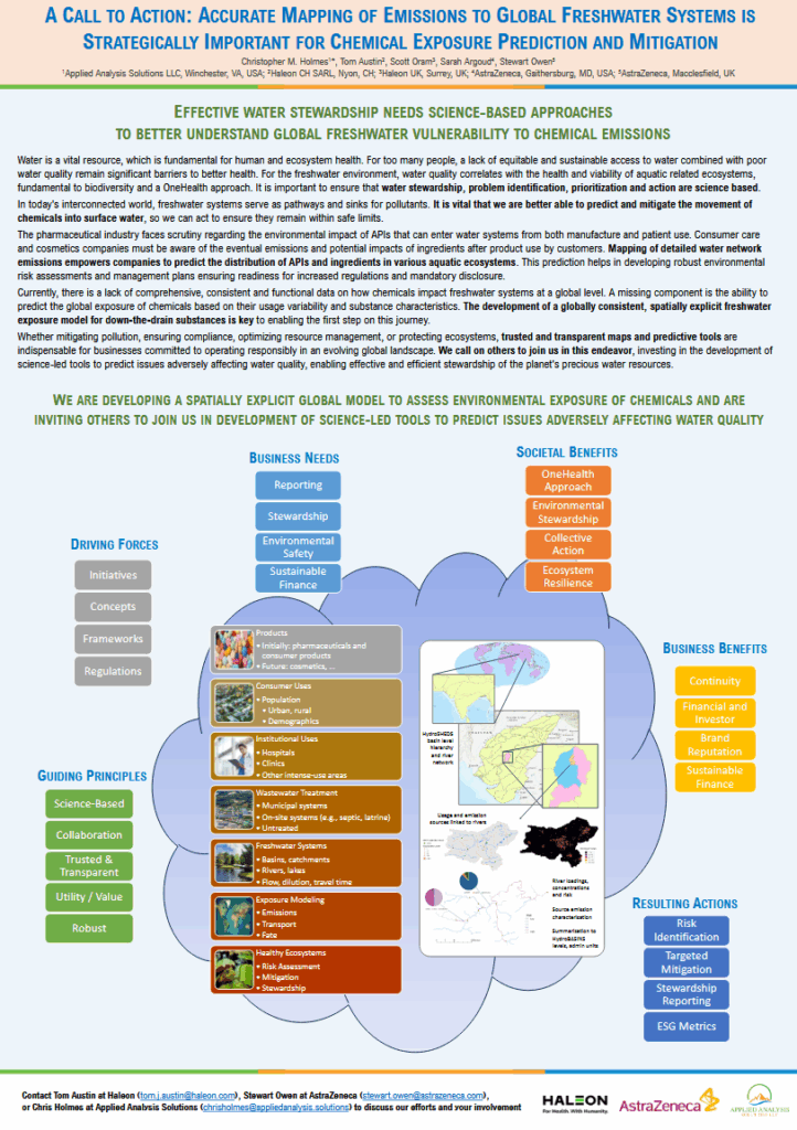
abstract = {Water is a vital resource, which is fundamental for human and ecosystem health. For too many people, a lack of equitable and sustainable access to water combined with poor water quality remain significant barriers to better health. For the freshwater environment, water quality correlates with the health and viability of aquatic related ecosystems, fundamental to biodiversity and a OneHealth approach. It is important to ensure that water stewardship, problem identification, prioritization and action are science based. In today's interconnected world, freshwater systems serve as pathways and sinks for pollutants. It is vital that we are better able to predict and mitigate the movement of chemicals into surface water, so we can act to ensure they remain within safe limits. The pharmaceutical industry faces scrutiny regarding the environmental impact of APIs that can enter water systems from both manufacture and patient use. Consumer care and cosmetics companies must be aware of the eventual emissions and potential impacts of ingredients after product use by customers. Mapping of detailed water network emissions empowers companies to predict the distribution of APIs and ingredients in various aquatic ecosystems. This prediction helps in developing robust environmental risk assessments and management plans ensuring readiness for increased regulations and mandatory disclosure. Currently, there is a lack of comprehensive, consistent and functional data on how chemicals impact freshwater systems at a global level. A missing component is the ability to predict the global exposure of chemicals based on their usage variability and substance characteristics. The development of a globally consistent, spatially explicit freshwater exposure model for down-the-drain substances is key to enabling the first step on this journey. Whether mitigating pollution, ensuring compliance, optimizing resource management, or protecting ecosystems, trusted and transparent maps and predictive tools are indispensable for businesses committed to operating responsibly in an evolving global landscape. We call on others to join us in this endeavor, investing in the development of science-led tools to predict issues adversely affecting water quality, enabling effective and efficient stewardship of the planet's precious water resources.},
keywords = {2025, Poster, SETAC Europe},
pubstate = {published},
tppubtype = {presentation}
}
Holmes, C.E. (Applied Analysis Solutions, LLC); Schad, T. (Bayer AG, Crop Science Division); Bub, S. (Rheinland‐Pfälzische Technische Universität); Holmes, C.M. (Applied Analysis Solutions, LLC)
05.11.2025.
Abstract | Links | Tags: 2025, Poster, SETAC Europe
@misc{EU25CropProtection,
title = {xCropProtection: a Spatiotemporal Component to Simulate Prospective and Retrospective PPP Applications in Real World Landscapes},
author = {Holmes, C.E. (Applied Analysis Solutions, LLC) and Schad, T. (Bayer AG, Crop Science Division) and Bub, S. (Rheinland‐Pfälzische Technische Universität) and Holmes, C.M. (Applied Analysis Solutions, LLC)},
url = {https://appliedanalysis.solutions/wp-content/uploads/2025/05/SETAC-EU-2025-xCropProtection.pdf, View Poster},
year = {2025},
date = {2025-05-11},
urldate = {2025-05-11},
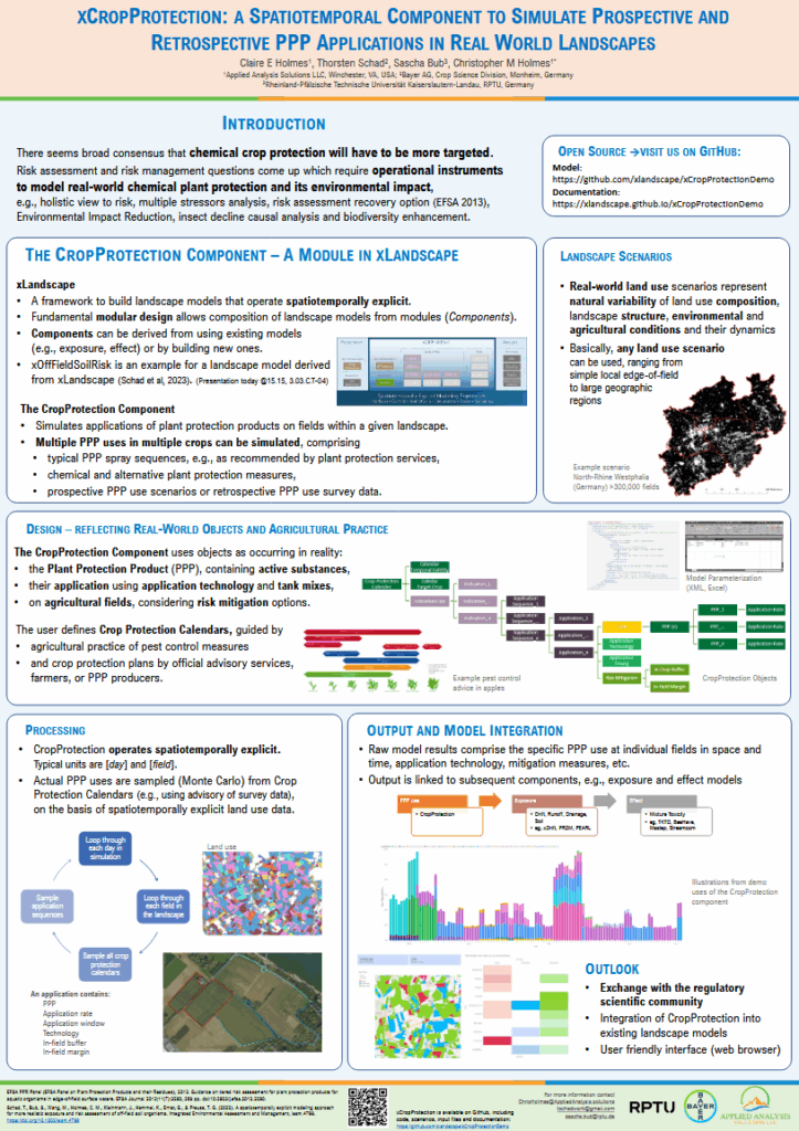
abstract = {There is currently both scientific and public discussion about chemical crop protection uses and trends. There seems to be consensus that chemical crop protection should be generally reduced or used more targeted in the future. In parallel there are requests for more realistic and holistic risk assessments of pesticides. We developed a spatiotemporally explicit component for simulating plant protection product (PPP) applications in landscapes which integrates with a larger spatiotemporal landscape model (xLandscape). This component, xCropProtection, can simulate applications at a field scale given PPP application information including target crops, spatial landscape information, and application periods. The result of running this component is a multidimensional dataset of PPP applications specific to individual fields and time steps. xCropProtection is parameterized with XML files, a file type used to store data in a hierarchical format well suited for sending and storing data. These XML files contain target crop types, PPP (or active substance) names, tank mixes, application rates (as a probability distribution function or a static value), probabilistic application windows, and mitigation measures for reducing exposure. xCropProtection functions both prospectively and retrospectively where input files can come from GAP tables in established risk assessment, can represent recommendations from plant protection advisory services, records from monitoring and field studies, or can be derived from market share grower surveys. xCropProtection is one component in the larger xLandscape framework that provides the simulation of more realistic pesticide applications for exposure, effect and risk assessments. },
keywords = {2025, Poster, SETAC Europe},
pubstate = {published},
tppubtype = {presentation}
}
Hodges, G. (Unilever Safety, Environmental & Regulatory Science); Hodges, J. (Unilever Safety, Environmental & Regulatory Science); Holmes, C.M. (Applied Analysis Solutions, LLC); Sheffield, D. (Unilever Safety, Environmental & Regulatory Science); Insinga, L. (Applied Analysis Solutions, LLC); Sandha, S. (Unilever Safety, Environmental & Regulatory Science); Tandy, E. (Applied Analysis Solutions, LLC); Dannatt, R. (Intertek Metoc); McGovern, K. (Intertek Metoc); Langley, E. (Intertek Metoc)
Estimating global spatially resolved marine emissions and exposure to down the drain chemicals Presentation
05.11.2025.
Abstract | Links | Tags: 2025, Poster, SETAC Europe
@misc{EU25Marine,
title = {Estimating global spatially resolved marine emissions and exposure to down the drain chemicals},
author = {Hodges, G. (Unilever Safety, Environmental & Regulatory Science) and Hodges, J. (Unilever Safety, Environmental & Regulatory Science) and Holmes, C.M. (Applied Analysis Solutions, LLC) and Sheffield, D. (Unilever Safety, Environmental & Regulatory Science) and Insinga, L. (Applied Analysis Solutions, LLC) and Sandha, S. (Unilever Safety, Environmental & Regulatory Science) and Tandy, E. (Applied Analysis Solutions, LLC) and Dannatt, R. (Intertek Metoc) and McGovern, K. (Intertek Metoc) and Langley, E. (Intertek Metoc)},
url = {https://appliedanalysis.solutions/wp-content/uploads/2025/05/SETAC-EU-202S-Marine-Modelling.pdf, View Poster},
year = {2025},
date = {2025-05-11},
urldate = {2025-05-11},
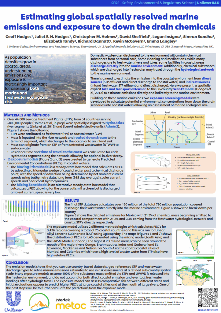
abstract = {Domestic wastewater discharged to the environment may contain chemical substances that are the result of human activity. While many discharges are to freshwater rivers and lakes, some facilities in coastal areas discharge directly into the marine environment. however many down-the-drain exposure models assume 100% of the chemical mass discharged from STPs or untreated populations is released into the freshwater environment A dataset was developed to understand what fraction of the population in coastal areas are served by STPs that discharge directly to a marine environment. Information on STP location, population served, and effluent flow were collected for 44,000 STPs across 34 countries serving almost 800 million people
Chemical substances are also discharged into freshwater which then may travel through the hydrological network to the marine environment. Hydrologic travel distance/time for each inland STP as well as untreated mass was developed along with estimated aquatic half-lives, to estimate discharges into rivers moving to coastal waters. The developed emission model is a mass balance model.
The third phase of the study developed two exposure models for 3436 regions covering 75 coastal countries to generate Predicted Environmental Concentrations (PEC s). The Moving Prism Model is a steady-state box model that calculates a PEC by advecting a triangular wedge of coastal water past a chemical discharge point, with the speed of advection being determined by net ambient current speeds using bathymetry data, long term (365-day average) scaler current speeds and near coast hydrodynamics. The Mixing Zone Model is an alternative steady-state box model that calculates a PEC should a chemical be discharged into still water (i.e. with no ambient current speed). Some initial comparisons to monitoring data show good agreement.
This work shows that it is possible to use country-based datasets including geo-referenced STP and wastewater discharge types to refine emissions estimates for use in environmental exposure models and risk assessments at a refined sub-country spatial scale.
The exposure model provides a screening level, globally-consistent approach for assessing the potential impact of down-the-drain chemicals on the marine environment. These models generate estimates of Predicted Environmental Concentration and represent an intermediate level between generic, multi-media models and detailed, data hungry process-based models.},
keywords = {2025, Poster, SETAC Europe},
pubstate = {published},
tppubtype = {presentation}
}
Chemical substances are also discharged into freshwater which then may travel through the hydrological network to the marine environment. Hydrologic travel distance/time for each inland STP as well as untreated mass was developed along with estimated aquatic half-lives, to estimate discharges into rivers moving to coastal waters. The developed emission model is a mass balance model.
The third phase of the study developed two exposure models for 3436 regions covering 75 coastal countries to generate Predicted Environmental Concentrations (PEC s). The Moving Prism Model is a steady-state box model that calculates a PEC by advecting a triangular wedge of coastal water past a chemical discharge point, with the speed of advection being determined by net ambient current speeds using bathymetry data, long term (365-day average) scaler current speeds and near coast hydrodynamics. The Mixing Zone Model is an alternative steady-state box model that calculates a PEC should a chemical be discharged into still water (i.e. with no ambient current speed). Some initial comparisons to monitoring data show good agreement.
This work shows that it is possible to use country-based datasets including geo-referenced STP and wastewater discharge types to refine emissions estimates for use in environmental exposure models and risk assessments at a refined sub-country spatial scale.
The exposure model provides a screening level, globally-consistent approach for assessing the potential impact of down-the-drain chemicals on the marine environment. These models generate estimates of Predicted Environmental Concentration and represent an intermediate level between generic, multi-media models and detailed, data hungry process-based models.
2024
LaRoe, J. (Applied Analysis Solutions, LLC); Kern, M. (Balance EcoSolutions, LLC); Holmes, C.M. (Applied Analysis Solutions, LLC)
Non-Agricultural Use Data Layers: Options and Methodologies for Supporting ESA Overlap Analysis Presentation
10.20.2024.
Abstract | Links | Tags: 2024, Poster, SETAC North America
@misc{NA24UDL,
title = {Non-Agricultural Use Data Layers: Options and Methodologies for Supporting ESA Overlap Analysis},
author = {LaRoe, J. (Applied Analysis Solutions, LLC) and Kern, M. (Balance EcoSolutions, LLC) and Holmes, C.M. (Applied Analysis Solutions, LLC)},
url = {https://appliedanalysis.solutions/wp-content/uploads/2024/10/SETAC-NA-2024-NonAgricultural-Use-Data-Layers-Options-and-Methodologies.pdf, View Poster},
year = {2024},
date = {2024-10-20},
urldate = {2024-10-20},
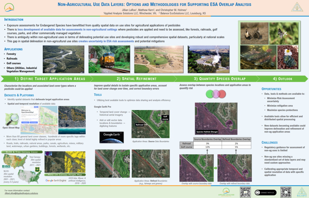
abstract = {Exposure assessments for Endangered Species have benefitted from quality spatial data on use sites for agricultural applications of pesticides. There is less development of available data for assessments in non-agricultural settings where pesticides are applied and need to be assessed, like forests, railroads, golf courses, parks, and other commercially managed vegetation. The emphasis on agricultural use sites has produced refined methodologies as well as defined and delineated data sets (e.g., Use Data Layers). However, there is ambiguity within non-agricultural uses in terms of delineating potential use sites and developing robust and comprehensive spatial datasets, particularly at national scales. Recent advancements in data processing/platforms along with the scale and extent of available spatial data present an opportunity to develop more comprehensive datasets for non-agricultural overlap analyses (relationship of use sites to species habitats). We have created customized approaches leveraging detailed datasets, like Open Street Map, to help fill this data gap. We incorporated additional information from other sources, such as historical high resolution aerial imagery, to support boundary editing and refinement of application areas. We present a combination of data sources and methods that can be tailored to curate data for specific objectives, tools and strategies to refine potential exposure for non-agricultural scenarios, as well as applied examples using golf courses, railroad vegetation management, and forests.},
keywords = {2024, Poster, SETAC North America},
pubstate = {published},
tppubtype = {presentation}
}
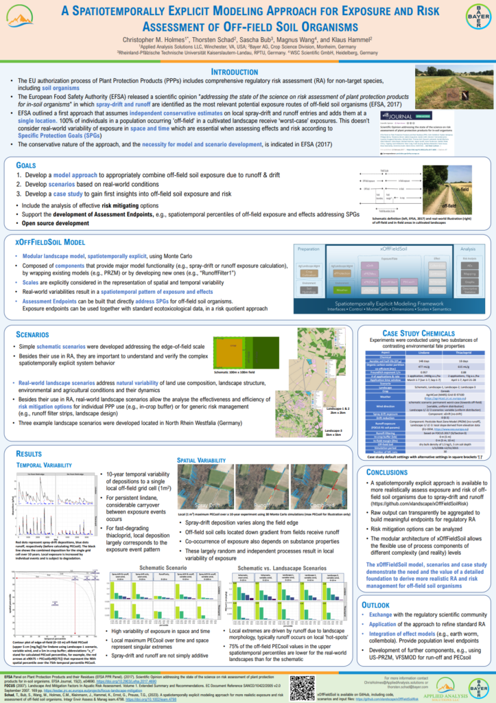
Holmes, C.M. (Applied Analysis Solutions, LLC); Schad, T. (Bayer CropScience); Bub, S. (Rheinland‐Pfälzische Technische Universität); Wang, M. (WSC Scientific GmbH); Hammel, K. (Bayer AG)
A Spatiotemporally Explicit Modeling Approach for Exposire and Risk Assessment of Off-field Soil Organisms Presentation
05.05.2024.
Abstract | Links | Tags: 2024, Poster, SETAC Europe
@misc{EU24xOffFieldSoil,

title = {A Spatiotemporally Explicit Modeling Approach for Exposire and Risk Assessment of Off-field Soil Organisms},

author = {Holmes, C.M. (Applied Analysis Solutions, LLC) and Schad, T. (Bayer CropScience) and Bub, S. (Rheinland‐Pfälzische Technische Universität) and Wang, M. (WSC Scientific GmbH) and Hammel, K. (Bayer AG)},

url = {https://appliedanalysis.solutions/wp-content/uploads/2024/05/SETAC-EU-2024-xOffFieldSoil.pdf, View Poster

https://github.com/xlandscape/xOffFieldSoilRisk, GitHub Repository},

year  = {2024},

date = {2024-05-05},

urldate = {2024-05-05},

abstract = {Natural and semi-natural habitats of soil living organisms in cultivated landscapes can be subject to unintended exposure by active substances of pesticides used in adjacent fields. Spray-drift deposition and runoff are considered major exposure routes into such off-field areas. In this work we develop a model (xOffFieldSoil) and associated scenarios to estimate exposure of off-field soil habitats at flexible levels of realism (https://github.com/xlandscape/xOffFieldSoilRisk). The modular approach consists of components each addressing a specific aspect of exposure processes, e.g., pesticide use, drift deposition, runoff generation and filtering, and PECsoil estimation. The approach is spatiotemporally explicit and operates at scales ranging from local edge-of-field to large landscapes. The outcome can be aggregated and presented as comprehensible endpoints to the risk assessor, considering ecologically relevant dimensions and scales for species protection. The approach also assesses the effect of mitigation options, e.g., field margins, in-field buffers, or drift-reducing technology. Presented scenarios start with a schematic edge-of-field situation and extend to real-world landscapes of up to 5 km x 5 km. A case study was conducted for two active substances of different environmental fate characteristics. Results are presented as a collection of percentiles over time and space, as contour plots and as maps. The results show that exposure patterns of off-field soil organisms are of a complex nature due to spatial and temporal variabilities combined with landscape structure and event-based processes. Our concepts and preliminary analysis demonstrate that more realistic exposure data can be meaningfully consolidated to serve in standard-tier risk assessments. The real-world landscape-scale scenarios indicate risk hot-spots which support the identification of efficient risk mitigation. As a next step, the spatiotemporally explicit exposure data can be directly coupled to ecological effect models (e.g., for earthworms or collembola) to conduct risk assessments at biological entity levels.},

keywords = {2024, Poster, SETAC Europe},

pubstate = {published},

tppubtype = {presentation}

}
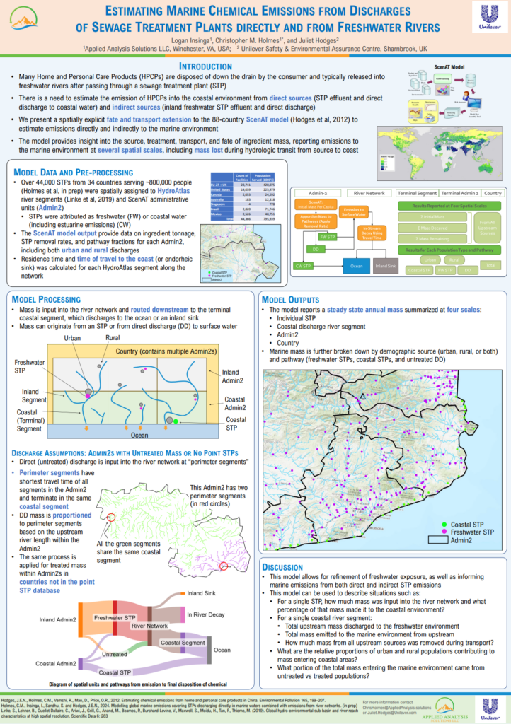
Insinga, L. (Applied Analysis Solutions, LLC); Holmes, C.M. (Applied Analysis Solutions, LLC); Hodges, J. (Unilever Safety & Environmental Assurance Centre)
Estimating Marine Chemical Emissions from Discharges of Sewage Treatment Plants Directly and from Freshwater Rivers Presentation
05.05.2024.
Abstract | Links | Tags: 2024, Poster, SETAC Europe
@misc{EU24STP,

title = {Estimating Marine Chemical Emissions from Discharges of Sewage Treatment Plants Directly and from Freshwater Rivers},

author = {Insinga, L. (Applied Analysis Solutions, LLC) and Holmes, C.M. (Applied Analysis Solutions, LLC) and Hodges, J. (Unilever Safety & Environmental Assurance Centre)},

url = {https://appliedanalysis.solutions/wp-content/uploads/2024/05/SETAC-EU-2024-Marine-Exposure-Model.pdf, View Poster},

year  = {2024},

date = {2024-05-05},

urldate = {2024-05-05},

abstract = {Changes in demographics are leading to greater urbanization and higher coastal populations which in turn is increasing the need to better understand chemical loading into coastal and marine environments. Many Home and Personal Care Products (HPCPs) are disposed of down the drain by the consumer, whereupon the ingredients typically are released into freshwater rivers having passed through upstream sewage treatment plants (STPs). Further transport to the marine environment can take place. However, there is a currently paucity of approaches to adequately estimate the extent of this emission route into the environment.


Following on from previous work from our group estimating chemical mass discharged directly into marine environments, here we present an approach which utilizes data on hydrologic travel distance/time for inland STPs combined with estimated aquatic half-lives to estimate emissions from upstream STPs into rivers flowing to coastal areas.


We have developed a spatially explicit fate and transport model to estimate emissions into the marine environment across 88 countries. This global model utilizes the HydroAtlas river dataset and covers 44,000 STPs in 34 countries which discharge into both freshwater and coastal waters directly. Ingredient mass discharged from freshwater STPs was estimated using hydrologic routing from the STP and estimated aquatic half-lives to the coastal discharge location. Discharged mass and percent of mass reaching the coast can then be calculated.

Resulting information can be used to refine emission estimates of ingredients into marine environments based on population demographics, disposal scenarios, and STP hydrologic distance to the coast. Results can also be used to inform more refined marine exposure modelling for risk assessment purposes.},

keywords = {2024, Poster, SETAC Europe},

pubstate = {published},

tppubtype = {presentation}

}
Following on from previous work from our group estimating chemical mass discharged directly into marine environments, here we present an approach which utilizes data on hydrologic travel distance/time for inland STPs combined with estimated aquatic half-lives to estimate emissions from upstream STPs into rivers flowing to coastal areas.
We have developed a spatially explicit fate and transport model to estimate emissions into the marine environment across 88 countries. This global model utilizes the HydroAtlas river dataset and covers 44,000 STPs in 34 countries which discharge into both freshwater and coastal waters directly. Ingredient mass discharged from freshwater STPs was estimated using hydrologic routing from the STP and estimated aquatic half-lives to the coastal discharge location. Discharged mass and percent of mass reaching the coast can then be calculated.
Resulting information can be used to refine emission estimates of ingredients into marine environments based on population demographics, disposal scenarios, and STP hydrologic distance to the coast. Results can also be used to inform more refined marine exposure modelling for risk assessment purposes.
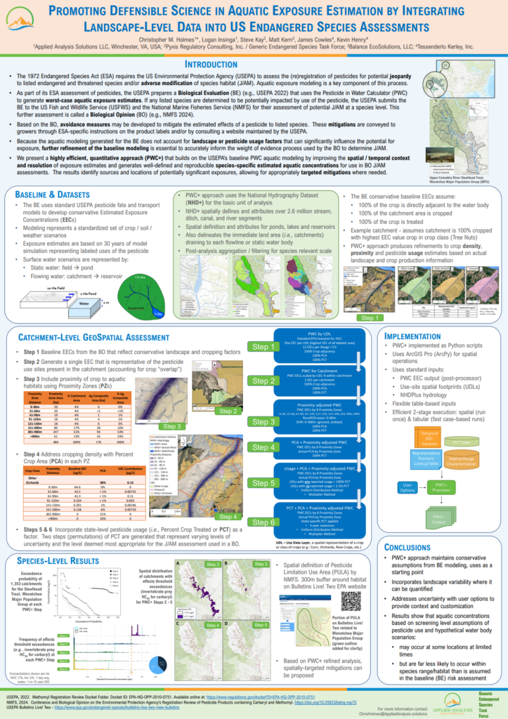
Holmes, C.M. (Applied Analysis Solutions, LLC); Insinga, L. (Applied Analysis Solutions, LLC); Kay, S. (Pyxis Regulatory Consulting, Inc); Kern, M. (Balance EcoSolutions, LLC); Henry, K. (Tessenderlo Kerley, Inc.)
05.05.2024.
Abstract | Links | Tags: 2024, Poster, SETAC Europe
@misc{EU24PWC+,

title = {Promoting Defensible Science in Aquatic Exposure Estimation by Integrating Landscape-Level Data into US Endangered Species Assessments},

author = {Holmes, C.M. (Applied Analysis Solutions, LLC) and Insinga, L. (Applied Analysis Solutions, LLC) and Kay, S. (Pyxis Regulatory Consulting, Inc) and Kern, M. (Balance EcoSolutions, LLC) and Henry, K. (Tessenderlo Kerley, Inc.)},

url = {https://appliedanalysis.solutions/wp-content/uploads/2024/05/SETAC-EU-2024-PWCPlus.pdf, View Poster},

year  = {2024},

date = {2024-05-05},

urldate = {2024-05-05},

abstract = {Prospective aquatic exposure modeling is a key component of the assessment of potential jeopardy of endangered species during the preparation of a risk assessment related to federal US pesticide (re)registration. The “Biological Evaluation” prepared by the US Environmental Protection Agency (USEPA) provides the foundation of aquatic exposure estimates using well-established pesticide fate and transport models applied to a standardized set of crop/soil/weather scenarios. Exposure estimates are based on 30 years of model simulation representing labeled uses of the pesticide assuming maximum application rates, maximum number of applications, and minimum re-application intervals, as well as assuming treated crop is adjacent to the aquatic environment. This modeling forms the basis from which subsequent refinements incorporating spatial, temporal, and pesticide usage variability can be applied. Further refinement of the screening-level modeling is essential to more accurately inform the weight of evidence process used by the US Fish and Wildlife Service and National Marine Fisheries Service to determine species jeopardy in the next stage of the assessment, the “Biological Opinion”.

To support this refinement, we present a highly efficient, quantitative approach that builds on the USEPA’s aquatic modeling by increasing the spatial/temporal context and resolution of exposure estimates to species of interest and producing well-defined and reproducible species-specific estimated aquatic concentrations. Utilizing data for each species, a set of high-resolution catchments, landscape-based crop proximity and density, and pesticide usage, inputs were processed to produce landscape-level exposure concentrations suitable for aggregation at multiple spatial scales appropriate for the species being examined. These refinements show that aquatic concentrations based on screening level assumptions of pesticide use and hypothetical water body scenarios may occur at some locations at limited times, but they are far less likely to occur within species range/habitat than is assumed in the screening-level risk assessments.

The methodologies presented are a quantitative approach to refining aquatic exposure estimates that incorporate variations in landscape and agronomic practices near endangered species locations and provide essential information to help inform localized mitigations for individual species across specific use patterns.},

keywords = {2024, Poster, SETAC Europe},

pubstate = {published},

tppubtype = {presentation}

}
To support this refinement, we present a highly efficient, quantitative approach that builds on the USEPA’s aquatic modeling by increasing the spatial/temporal context and resolution of exposure estimates to species of interest and producing well-defined and reproducible species-specific estimated aquatic concentrations. Utilizing data for each species, a set of high-resolution catchments, landscape-based crop proximity and density, and pesticide usage, inputs were processed to produce landscape-level exposure concentrations suitable for aggregation at multiple spatial scales appropriate for the species being examined. These refinements show that aquatic concentrations based on screening level assumptions of pesticide use and hypothetical water body scenarios may occur at some locations at limited times, but they are far less likely to occur within species range/habitat than is assumed in the screening-level risk assessments.
The methodologies presented are a quantitative approach to refining aquatic exposure estimates that incorporate variations in landscape and agronomic practices near endangered species locations and provide essential information to help inform localized mitigations for individual species across specific use patterns.
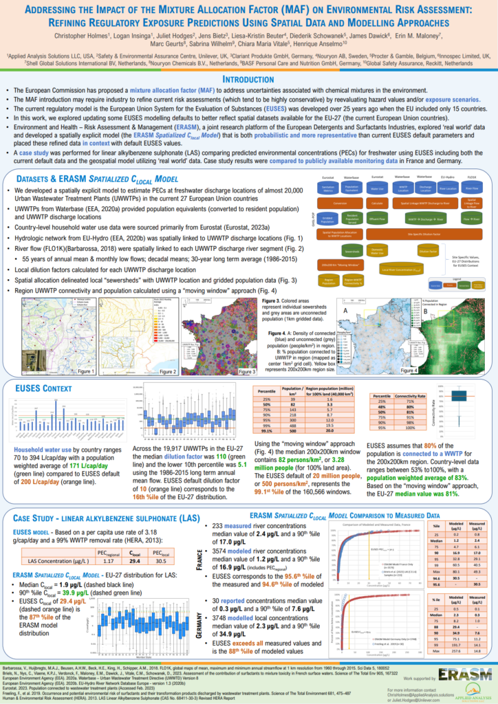
Holmes, C.M. (Applied Analysis Solutions, LLC); Insinga, L. (Applied Analysis Solutions, LLC); Hodges, J. (Unilever Safety & Environmental Assurance Centre); Bietz, J. (Clariant Produkte GmbH); Beuter, L. (Nouryon AB); Schowanek, D. (Procter & Gamble); Dawich, J. (Innospec Limited); Maloney, E.M. (Shell Global Solutions International BV); Geurts, M. (Nouryon Chemicals B.V.); Wilhelm, S. (BASF Personal Care & Nutrition GbmH); Vitale, C.M. (Procter & Gamble); Anselmo, H. (Global Safety Assurance, Reckitt)
05.05.2024.
Abstract | Links | Tags: 2024, Poster, SETAC Europe
@misc{EU23MAF,

title = {Addressing the Impact of the Mixture Allocation Factor (MAF) on Environmental Risk Assessment: Refining Regulatory Exposure Predictions Using Spatial Data and Modelling Approaches},

author = {Holmes, C.M. (Applied Analysis Solutions, LLC) and Insinga, L. (Applied Analysis Solutions, LLC) and Hodges, J. (Unilever Safety & Environmental Assurance Centre) and Bietz, J. (Clariant Produkte GmbH) and Beuter, L. (Nouryon AB) and Schowanek, D. (Procter & Gamble) and Dawich, J. (Innospec Limited) and Maloney, E.M. (Shell Global Solutions International BV) and Geurts, M. (Nouryon Chemicals B.V.) and Wilhelm, S. (BASF Personal Care & Nutrition GbmH) and Vitale, C.M. (Procter & Gamble) and Anselmo, H. (Global Safety Assurance, Reckitt)},

url = {https://appliedanalysis.solutions/wp-content/uploads/2024/05/SETAC-EU-2024-ERASM-gridded-MAF.pdf, View Poster},

year  = {2024},

date = {2024-05-05},

urldate = {2024-05-05},

abstract = {Under the Chemical Strategy for Sustainability (CSS), the European Commission has proposed the use of a mixture allocation factor (MAF) to address uncertainties and risks associated with unintentional chemical mixtures in the environment. Currently it is thought that a MAF may need to be applied to all single chemical registrations for the higher tonnage bands. It is expected that additional exposure and/or effect data generation will be needed for the risk assessment, and in some cases further risk management measures may be required to ensure environmental safety.


The European Union System for the Evaluation of Substances (EUSES), also accessed via the CHESAR v1 tool is the standard model to determine exposure in support of chemical safety assessments (CSAs) under REACH. In the spirit of continuously refining safety assessments and models, we envisage an opportunity to update exposure model background data in EUSES/CHESAR in line with the evolution of wastewater treatment infrastructure in EU, and availability of better spatial datasets.  This would ensure that regulatory modelling remains aligned with most updated data available and the situation in the field.


In this work we explore field data and spatially explicit modelling approaches, some of which are probabilistic, in order to compare them with the current EUSES default parameters. We developed a spatially explicit model which applied the EUSES PEC calculation to estimate environmental concentrations at freshwater discharge locations of almost 22,000 European Urban Wastewater Treatment Plants (UWWTPs). Specifically, using publicly available data, we examined per capita water use, UWWTP connectivity and local UWWTP dilution factors to generate EU-wide distributions and to place these in context with default EUSES values.


We demonstrate that spatially explicit exposure models are feasible for use in regulatory modelling and can give more realistic predicted environmental concentrations (PECs). Case studies have been performed comparing PEClocal values for freshwater using CHESAR v1 including both the current default data and the spatial approach.  We expect that higher tier exposure data will be increasingly needed to ascertain that risk quotients remain acceptable even with a MAF applied.},

keywords = {2024, Poster, SETAC Europe},

pubstate = {published},

tppubtype = {presentation}

}
The European Union System for the Evaluation of Substances (EUSES), also accessed via the CHESAR v1 tool is the standard model to determine exposure in support of chemical safety assessments (CSAs) under REACH. In the spirit of continuously refining safety assessments and models, we envisage an opportunity to update exposure model background data in EUSES/CHESAR in line with the evolution of wastewater treatment infrastructure in EU, and availability of better spatial datasets. This would ensure that regulatory modelling remains aligned with most updated data available and the situation in the field.
In this work we explore field data and spatially explicit modelling approaches, some of which are probabilistic, in order to compare them with the current EUSES default parameters. We developed a spatially explicit model which applied the EUSES PEC calculation to estimate environmental concentrations at freshwater discharge locations of almost 22,000 European Urban Wastewater Treatment Plants (UWWTPs). Specifically, using publicly available data, we examined per capita water use, UWWTP connectivity and local UWWTP dilution factors to generate EU-wide distributions and to place these in context with default EUSES values.
We demonstrate that spatially explicit exposure models are feasible for use in regulatory modelling and can give more realistic predicted environmental concentrations (PECs). Case studies have been performed comparing PEClocal values for freshwater using CHESAR v1 including both the current default data and the spatial approach. We expect that higher tier exposure data will be increasingly needed to ascertain that risk quotients remain acceptable even with a MAF applied.
LaRoe, J. (Applied Analysis Solutions, LLC); Holmes, C.M. (Applied Analysis Solutions, LLC); Schad, T. (Bayer CropScience)
05.05.2024.
Abstract | Links | Tags: 2024, Poster, SETAC Europe
@misc{EU24birds,
title = {Spatial Approaches to Field Study Characterisation and Representativeness to Address EFSA Guidance on the Risk Assessment for Birds and Mammals},
author = {LaRoe, J. (Applied Analysis Solutions, LLC) and Holmes, C.M. (Applied Analysis Solutions, LLC) and Schad, T. (Bayer CropScience)},
url = {https://appliedanalysis.solutions/wp-content/uploads/2024/05/SETAC-EU-2024-Birds-and-mammals.pdf, View Poster},
year = {2024},
date = {2024-05-05},
urldate = {2024-05-05},
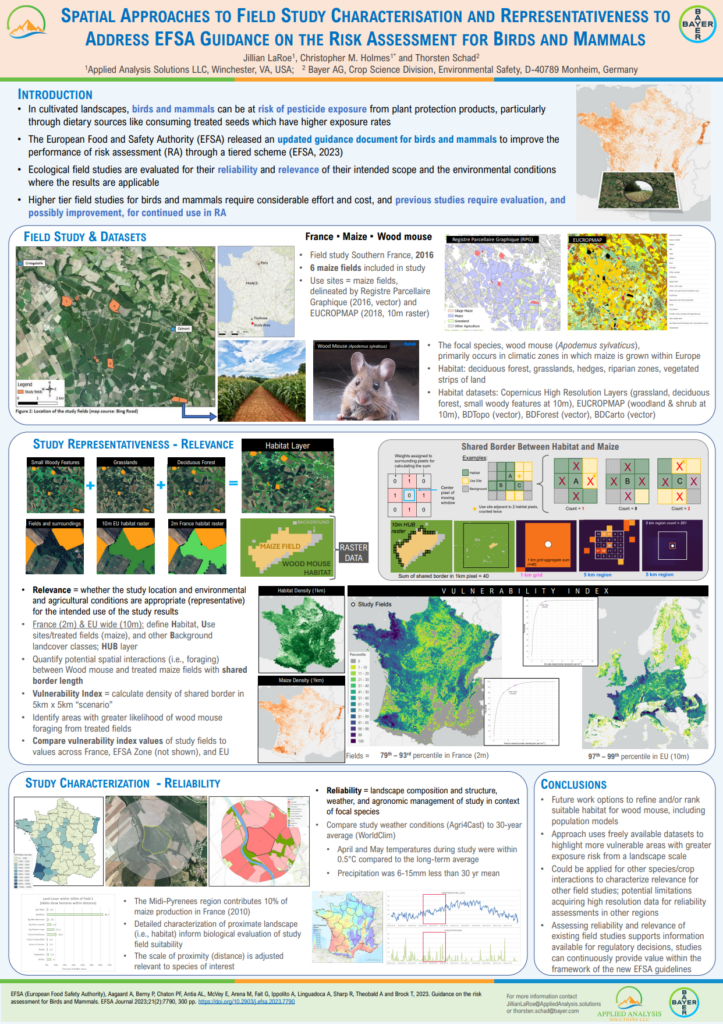
abstract = {New EFSA guidance on the Risk assessment for Birds and Mammals includes updates relating to the improvement of terrestrial vertebrate (TV) field studies for use in risk assessment of Plant Protection Products containing pesticide active substances. Within the guidance, two concepts are discussed: Field Study Characterisation and Field Study Representativeness. To address these concepts, a past terrestrial vertebrate field study was assessed and updated to address the new guidance needs for characterisation and representativeness.
Field study characterisation involved collection and analysis of spatial data available for the study area and relevant to the species, including agricultural fields, grasslands, woody vegetation, forest, water/riparian areas. Percent area metrics were generated for several distances around the study fields, as well as examination of high-resolution imagery suitable for expert evaluation. Weather conditions during the field study were compared against 30-year monthly norms to verify the study year was not outside of expected variation from long-term averages.
Field study representativeness was assessed at multiple scales, including EU, EFSA zone and Member State. The potential for species interaction between “habitat” (a proxy defined by spatial land cover data) with “use sites” (assumed treated fields by crop type derived from agricultural maps) was processed using gridded spatial data at a resolution of 10m. Shared border between habitat and use sites served as an interaction indicator summarized at the 1-km scale (i.e., how many of the 10mx10m use site grid cells were adjacent to habitat cells). The 1-km scale is suitable for further aggregation at various sizes based on species attributes. In this case, local landscape interactions were assessed by developing “scenarios” a 5kmx5km summation of the interaction indicator which was quantified across all EU member states.
The scenario(s) encompassing the study fields were placed into the full distribution of all possible scenarios (EU, EFSA zone, Member State) to assess the study location relative to all possible use site / habitat interactions (i.e., possible field study locations). The quantitative approaches developed here can also be used to prepare upcoming generic terrestrial vertebrate field study designs and support optimized study site selection to meet the new EFSA guidance requirements.},
keywords = {2024, Poster, SETAC Europe},
pubstate = {published},
tppubtype = {presentation}
}
Field study characterisation involved collection and analysis of spatial data available for the study area and relevant to the species, including agricultural fields, grasslands, woody vegetation, forest, water/riparian areas. Percent area metrics were generated for several distances around the study fields, as well as examination of high-resolution imagery suitable for expert evaluation. Weather conditions during the field study were compared against 30-year monthly norms to verify the study year was not outside of expected variation from long-term averages.
Field study representativeness was assessed at multiple scales, including EU, EFSA zone and Member State. The potential for species interaction between “habitat” (a proxy defined by spatial land cover data) with “use sites” (assumed treated fields by crop type derived from agricultural maps) was processed using gridded spatial data at a resolution of 10m. Shared border between habitat and use sites served as an interaction indicator summarized at the 1-km scale (i.e., how many of the 10mx10m use site grid cells were adjacent to habitat cells). The 1-km scale is suitable for further aggregation at various sizes based on species attributes. In this case, local landscape interactions were assessed by developing “scenarios” a 5kmx5km summation of the interaction indicator which was quantified across all EU member states.
The scenario(s) encompassing the study fields were placed into the full distribution of all possible scenarios (EU, EFSA zone, Member State) to assess the study location relative to all possible use site / habitat interactions (i.e., possible field study locations). The quantitative approaches developed here can also be used to prepare upcoming generic terrestrial vertebrate field study designs and support optimized study site selection to meet the new EFSA guidance requirements.
2023
LaRoe, J. (Applied Analysis Solutions, LLC); Holmes, C.M. (Applied Analysis Solutions, LLC); Schad, T. (Bayer AG)
04.30.2023.
Links | Tags: 2023, Poster, SETAC Europe
@misc{2023EUScenario,

title = {Using Remote Sensing Methods to Characterize Grassland Landscapes for Scenario Development and Biodiversity Assessment},

author = {LaRoe, J. (Applied Analysis Solutions, LLC) and Holmes, C.M. (Applied Analysis Solutions, LLC) and Schad, T. (Bayer AG)},

url = {https://appliedanalysis.solutions/wp-content/uploads/2023/08/SETAC-EU-2023-GrasslandPoster-final.pdf, View Poster},

year  = {2023},

date = {2023-04-30},

urldate = {2023-04-30},

keywords = {2023, Poster, SETAC Europe},

pubstate = {published},

tppubtype = {presentation}

}

Holmes, C.M. (Applied Analysis Solutions, LLC); Maltby, L. (The University of Sheffield); Sweeney, P. (Syngenta); Thorbek, P. (BASF); Otte, J.C. (BASF); Marshall, S. (Consultant, UK)
04.30.2023.
Links | Tags: 2023, Poster, SETAC Europe
@misc{EU2023Heterogeneity,

title = {Heterogeneity in Biological Assemblages and Exposure in Chemical Risk Assessment: Exploring Capabilities and Challenges in Methodology with Two Landscape-Scale Case Studies},

author = {Holmes, C.M. (Applied Analysis Solutions, LLC) and Maltby, L. (The University of Sheffield) and Sweeney, P. (Syngenta) and Thorbek, P. (BASF) and Otte, J.C. (BASF) and Marshall, S. (Consultant, UK)},

url = {https://appliedanalysis.solutions/wp-content/uploads/2023/08/SETAC-EU-2023-4.01.P-Mo263-Geo-ref-TF.pdf, View Poster},

year  = {2023},

date = {2023-04-30},

urldate = {2023-04-30},

keywords = {2023, Poster, SETAC Europe},

pubstate = {published},

tppubtype = {presentation}

}
2022
LaRoe, J. (Applied Analysis Solutions, LLC); Holmes, C.M. (Applied Analysis Solutions, LLC); Schad, T. (Bayer AG)
11.13.2022.
Links | Tags: 2022, Poster, SETAC North America
@misc{NA2022Grassland,

title = {Using Remote Sensing Methods to Characterize Grassland Landscapes and Management Practices for Ecological Health Investigations},

author = {LaRoe, J. (Applied Analysis Solutions, LLC) and Holmes, C.M. (Applied Analysis Solutions, LLC) and Schad, T. (Bayer AG)},

url = {https://appliedanalysis.solutions/wp-content/uploads/2023/08/SETAC-NA-2022-Characterize-Grassland.pdf, View Poster},

year  = {2022},

date = {2022-11-13},

urldate = {2022-11-13},

keywords = {2022, Poster, SETAC North America},

pubstate = {published},

tppubtype = {presentation}

}
LaRoe, J. (Applied Analysis Solutions, LLC)
INHABIT for Broad-Scale Assessment of Invasive Terrestrial Vegetation Species Presentation
11.13.2022.
Links | Tags: 2022, Poster, SETAC North America
@misc{NA2022INHABIT,

title = {INHABIT for Broad-Scale Assessment of Invasive Terrestrial Vegetation Species},

author = {LaRoe, J. (Applied Analysis Solutions, LLC)},

url = {https://appliedanalysis.solutions/wp-content/uploads/2023/08/SETAC-NA-2022-INHABIT.pdf, View Poster},

year  = {2022},

date = {2022-11-13},

urldate = {2022-11-13},

keywords = {2022, Poster, SETAC North America},

pubstate = {published},

tppubtype = {presentation}

}

Holmes, C.M. (Applied Analysis Solutions, LLC); Schad, T. (Bayer AG); Preuss, T. (University of Koblenz-Landau, Germany)
Scenario Development for Bee Risk Assessment and Health Modelling Presentation
11.13.2022.
Links | Tags: 2022, Poster, SETAC North America
@misc{NA2022Bee,

title = {Scenario Development for Bee Risk Assessment and Health Modelling},

author = {Holmes, C.M. (Applied Analysis Solutions, LLC) and Schad, T. (Bayer AG) and Preuss, T. (University of Koblenz-Landau, Germany)},

url = {https://appliedanalysis.solutions/wp-content/uploads/2023/08/SETAC-NA-2022-BeeForage.pdf, View Poster},

year  = {2022},

date = {2022-11-13},

urldate = {2022-11-13},

keywords = {2022, Poster, SETAC North America},

pubstate = {published},

tppubtype = {presentation}

}
2021
Holmes, C.M. (Applied Analysis Solutions, LLC); Marshall, S. (Consultant, UK); Maltby, L. (The University of Sheffield); Sweeney, P. (Syngenta); Thorbek, P. (BASF); Otte, J.C. (BASF)
05.02.2021.
Links | Tags: 2021, Poster, Presentation, SETAC Europe
@misc{2021EU2study,
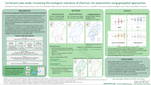
title = {Increasing Ecological Relevance of Chemical Risk Assessments Using Geospatial Approaches: Results From Two Case Studies},
author = {Holmes, C.M. (Applied Analysis Solutions, LLC) and Marshall, S. (Consultant, UK) and Maltby, L. (The University of Sheffield) and Sweeney, P. (Syngenta) and Thorbek, P. (BASF) and Otte, J.C. (BASF)},
url = {https://appliedanalysis.solutions/wp-content/uploads/2020/12/SETAC-EU-2021-ECETOC-extended-abstract.pdf, Extended abstract
https://appliedanalysis.solutions/wp-content/uploads/2021/06/SETAC-EU-2021-ECETOC-platform-final.pdf, Presentation slides
https://appliedanalysis.solutions/wp-content/uploads/2021/06/SETAC-EU-2021-ECETOC-platform-final.pdf, Surfactant case study poster
https://appliedanalysis.solutions/wp-content/uploads/2021/06/SETAC-EU-2021-ECETOC-PPP-case-study-poster-final.pdf, PPP case study poster
https://www.youtube.com/watch?v=ZdxQrdubIs8, Presentation video},
year = {2021},
date = {2021-05-02},
urldate = {2021-05-02},
keywords = {2021, Poster, Presentation, SETAC Europe},
pubstate = {published},
tppubtype = {presentation}
}

Holmes, C.M. (Applied Analysis Solutions, LLC); Tandy, E. (Applied Analysis Solutions, LLC); Schleicher, Z. (Southern Illinois University, Edwardsville); Kilgallon, J. (Unilever Safety & Environmental Assurance Centre); Hodges, J. (Unilever Safety & Environmental Assurance Centre)
2021.
Links | Tags: 2021, Poster, SETAC Europe
@conference{2021Marine,

title = {Estimating Domestic Wastewater Emissions to Marine Environments Using a Spatial Extrapolation Approach},

author = {Holmes, C.M. (Applied Analysis Solutions, LLC) and Tandy, E. (Applied Analysis Solutions, LLC) and Schleicher, Z. (Southern Illinois University, Edwardsville) and Kilgallon, J. (Unilever Safety & Environmental Assurance Centre) and Hodges, J. (Unilever Safety & Environmental Assurance Centre)},

url = {https://appliedanalysis.solutions/wp-content/uploads/2021/06/SETAC-EU-2021-Marine-emission-poster-final.pdf, View poster},

year  = {2021},

date = {2021-05-02},

urldate = {2021-05-02},

keywords = {2021, Poster, SETAC Europe},

pubstate = {published},

tppubtype = {conference}

}
2019
Holmes, C.M. (Applied Analysis Solutions, LLC); Amos, J. (Waterborne Environmental, Inc); Snyder, N. (Waterborne Environmental, Inc); Kern, M. (Waterborne Environmental, Inc); Cowles, J. (Tessenderlo Kerley, Inc.); Henry, K. (Tessenderlo Kerley, Inc.)
11.03.2019.
Abstract | Links | Tags: 2019, Poster, SETAC North America
@misc{2019NAPest,
title = {Sources, Characteristics and Opportunities for Pesticide Use and Usage Information Applied to Listed Species Risk Assessment},
author = {Holmes, C.M. (Applied Analysis Solutions, LLC) and Amos, J. (Waterborne Environmental, Inc) and Snyder, N. (Waterborne Environmental, Inc) and Kern, M. (Waterborne Environmental, Inc) and Cowles, J. (Tessenderlo Kerley, Inc.) and Henry, K. (Tessenderlo Kerley, Inc.)},
url = {https://appliedanalysis.solutions/wp-content/uploads/2020/06/SETAC-NA-GESTF-Usage-poster-01Nov2019.pdf, View poster},
year = {2019},
date = {2019-11-03},
urldate = {2019-11-03},
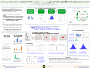
abstract = {The challenges inherent in national-level pesticide endangered species risk assessments are many, varied and have been the topic of meetings, workshops, presentations and publications for many years. One challenge is the identification and incorporation of pesticide usage information in the risk assessment process. Pesticide “usage” differs from pesticide “use”, where “use” is defined by registered labels and describes limits on how the pesticide may be applied (i.e., maximum rates and number of applications), while “usage” describes documented applications with specific information on each individual event. Incorporating usage information into the risk characterization during the Biological Evaluation and Biological Opinion development process is an area of renewed interest. This poster will describe several sources of pesticide usage information (e.g., USDA Agricultural Chemical Use Program, CA DPR Pesticide Use Reporting), and how relevant field-level pesticide application information can be extracted. Examples will be given showing how these data can be utilized to refine our understanding of specific active ingredients and their associated spatial and temporal variation across use areas, and how this can inform the exposure analysis within each Step of the ESA consultation process.},
keywords = {2019, Poster, SETAC North America},
pubstate = {published},
tppubtype = {presentation}
}
Holmes, C.M. (Applied Analysis Solutions, LLC); Amos, J. (Waterborne Environmental, Inc); Dyer, S. (Waterborne Environmental, Inc)
Modeling Aquatic and Terrestrial Transport Pathways for Microplastics Entering WWTP Systems Presentation
11.03.2019.
Abstract | Links | Tags: 2019, Poster, SETAC North America
@misc{2019NAWWTP,
title = {Modeling Aquatic and Terrestrial Transport Pathways for Microplastics Entering WWTP Systems},
author = {Holmes, C.M. (Applied Analysis Solutions, LLC) and Amos, J. (Waterborne Environmental, Inc) and Dyer, S. (Waterborne Environmental, Inc)},
url = {https://appliedanalysis.solutions/wp-content/uploads/2020/01/SETAC-NA-Particle-model-poster-01Nov2019.pdf, View poster},
year = {2019},
date = {2019-11-03},
urldate = {2019-11-03},
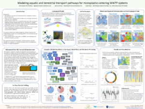
abstract = {Microplastics may enter the environment from a number of sources and in many forms. Plastic particles may be present as influent into municipal wastewater treatment plants (WWTPs). A large portion of these are removed from the water phase during the treatment process, and generally end up in the solids (i.e., sludge). Sludge disposal varies by country, region and locality, including landfill, incinerator, compost, or as land-applied biosolids. There is potential for particles in biosolid applications to reach aquatic systems depending on application location and subsequent environmental conditions. We present a broad-scale model designed to estimate emissions and model the fate of plastic particles exiting WWTPs into the terrestrial and aquatic environments, using spatially-explicit information on WWTPs, river hydrology and terrestrial transport potential. This regional/continental scale model is based on publicly available datasets and contained in a modular and transparent framework which is scalable and portable to multiple geographies. This presentation will demonstrate the utility of the model as applied to different regions, and how the resulting information about ultimate mass disposition within the environment (e.g., soil, freshwater, sediment, marine) and surface water concentrations can be examined to help inform the discussion about prospectively assessing the presence and concentration of microplastic particles in the environment as emitted by WWTPs.},
keywords = {2019, Poster, SETAC North America},
pubstate = {published},
tppubtype = {presentation}
}
Holmes, C.M. (Applied Analysis Solutions, LLC); Maltby, L. (The University of Sheffield); Marshall, S. (Consultant, UK); Otte, J.C. (BASF); Sweeney, P. (Syngenta); Thorbek, P. (BASF)
Geospatial Approaches to Increasing the Ecological Relevance of Environmental Risk Assessment Conference
2019.
Abstract | Links | Tags: 2019, Poster, SETAC North America
@conference{2019NAGeo,
title = {Geospatial Approaches to Increasing the Ecological Relevance of Environmental Risk Assessment},
author = {Holmes, C.M. (Applied Analysis Solutions, LLC) and Maltby, L. (The University of Sheffield) and Marshall, S. (Consultant, UK) and Otte, J.C. (BASF) and Sweeney, P. (Syngenta) and Thorbek, P. (BASF)},
url = {https://appliedanalysis.solutions/wp-content/uploads/2020/01/SETAC-NA-ECETOC-TF-poster-01Nov2019.pdf, View poster},
year = {2019},
date = {2019-11-03},
urldate = {2019-11-03},
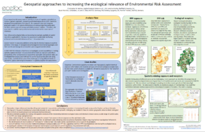
abstract = {For several decades, the prospective risk assessment of chemicals has followed a generic approach of comparing estimated exposures to toxic thresholds designed to be protective of all species (i.e., assessing exposure to the most sensitive species assumed to be located anywhere the chemical may occur in the environment). This approach does not recognize geographic patterns of species distributions or acknowledge that particularly sensitive species may not occupy potentially exposed habitats. Therefore, risk assessments could be overly conservative and restrictive for some uses of chemicals. Approaches for making spatially explicit assessments of chemical exposure are relatively advanced but this is not the case for mapping and assessing ecological data. However, geo-referenced ecological data appear to be increasingly available at spatial resolutions applicable to chemical risk assessment, potentially facilitating enhanced environmental relevance of such risk assessments. In 2017 a Task Force was initiated by European Centre for Ecotoxicology and Toxicology of Chemicals (ECETOC) to assess the capability of making chemical risk assessments using available geospatially referenced chemical exposure, ecological receptor and ecosystem services data. Two case studies were developed to illustrate the potential to assess geo-referenced risks to ecological receptors in fresh water and terrestrial environments exposed to i) a chemical used in consumer cleaning products discharged via municipal WWTPs across the EU and ii) a range of representative active ingredients used in plant protection products on selected crops in Germany. After initially compiling a catalogue of available geo-referenced ecological data for Europe, geo-referenced exposure concentrations were derived by combining accessible chemical use and fate data with conventional exposure models. However, use of many ecological data sets over a pan-European range proved problematic due to data access issues, limited geographic coverage and unreliable quality. Nevertheless, several suitable ecological data sets were accessed after making specific requests to various organizations within national authorities and these were integrated with the exposure maps. The results of these case studies give an indication of the potential value of making geo-referenced chemical risk assessments as well as the limitations to current capability.},
keywords = {2019, Poster, SETAC North America},
pubstate = {published},
tppubtype = {conference}
}
2018
Holmes, C.M. (Waterborne Environmental, Inc); Amos, J. (Waterborne Environmental, Inc); Ritter, A. (Waterborne Environmental, Inc); Williams, M. (Waterborne Environmental, Inc)
11.04.2018.
Links | Tags: 2018, Poster, SETAC North America
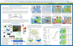
@misc{2018Toolbox,

title = {A New Tool for the Toolbox: Predicting Multi-Pathway Emission and Fate of Contaminants Entering Freshwater Systems in Europe},

author = {Holmes, C.M. (Waterborne Environmental, Inc) and Amos, J. (Waterborne Environmental, Inc) and Ritter, A. (Waterborne Environmental, Inc) and Williams, M. (Waterborne Environmental, Inc)},

url = {https://appliedanalysis.solutions/wp-content/uploads/2021/01/SETAC_NA_2018_Multipathway.pdf, View poster

https://www.waterborne-env.com/wp-content/uploads/MP068_Holmes_Multipathway_final.pdf, Poster originally available from Waterborne Environmental},

year  = {2018},

date = {2018-11-04},

urldate = {2018-11-04},

organization = {SETAC North America},

keywords = {2018, Poster, SETAC North America},

pubstate = {published},

tppubtype = {presentation}

}